
Huntsville, Arkansas facts for kids
Quick facts for kids
Huntsville, Arkansas
|
|||
|---|---|---|---|

Huntsville Commercial Historic District
|
|||
|
|||
| Motto(s):
"Crossroads of the Ozarks"
|
|||

Location in Madison County, Arkansas
|
|||
| Country | United States | ||
| State | Arkansas | ||
| County | Madison | ||
| Area | |||
| • Total | 5.40 sq mi (13.98 km2) | ||
| • Land | 5.38 sq mi (13.94 km2) | ||
| • Water | 0.02 sq mi (0.05 km2) | ||
| Elevation | 1,486 ft (453 m) | ||
| Population
(2020)
|
|||
| • Total | 2,879 | ||
| • Density | 534.93/sq mi (206.55/km2) | ||
| Time zone | UTC-6 (Central (CST)) | ||
| • Summer (DST) | UTC-5 (CDT) | ||
| ZIP code |
72740
|
||
| Area code(s) | 479 | ||
| FIPS code | 05-33970 | ||
| GNIS feature ID | 2404747 | ||


Huntsville is a city in Arkansas, United States. It is the main town, or "county seat," of Madison County. In 2020, about 2,879 people lived there. That's more than the 2,346 people who lived there in 2010! Huntsville is part of the Northwest Arkansas region. It was also a place where events happened during the American Civil War.
Contents
History of Huntsville
Huntsville is named after Huntsville, Alabama. Some of the first people to settle here came from that city.
Huntsville officially became a town after the American Civil War in 1877. Later, on July 16, 1925, it officially became a city.
Geography and Location
Huntsville is in the northwest part of Arkansas. It is located in an area called the Ozarks. The city is north of the center of Madison County.
You can reach Huntsville by U.S. Route 412. It's about 28 miles (45 km) east of Springdale. It is also about 47 miles (76 km) west of Harrison.
Land and Water Features
The city covers a total area of about 5.4 square miles (14 square kilometers). Only a very small part of this area, about 0.02 square miles (0.05 square kilometers), is water.
A small stream called Town Branch flows north through the east side of Huntsville. It joins Holman Creek in the northern part of the city. Holman Creek then flows north into War Eagle Creek. This creek continues northwest to the White River, which is east of Springdale.
People of Huntsville
| Historical population | |||
|---|---|---|---|
| Census | Pop. | %± | |
| 1850 | 255 | — | |
| 1860 | 251 | −1.6% | |
| 1870 | 224 | −10.8% | |
| 1880 | 312 | 39.3% | |
| 1890 | 362 | 16.0% | |
| 1930 | 602 | — | |
| 1940 | 776 | 28.9% | |
| 1950 | 1,010 | 30.2% | |
| 1960 | 1,050 | 4.0% | |
| 1970 | 1,287 | 22.6% | |
| 1980 | 1,394 | 8.3% | |
| 1990 | 1,605 | 15.1% | |
| 2000 | 1,931 | 20.3% | |
| 2010 | 2,346 | 21.5% | |
| 2020 | 2,879 | 22.7% | |
| U.S. Decennial Census | |||
Population in 2020
In 2020, there were 2,879 people living in Huntsville. There were 866 households and 517 families. The population density was about 640 people per square mile (247 people per square kilometer).
There were 1,116 housing units in the city. About 34.6% of households had children under 18 living with them. About 41.1% were married couples.
The average household had 2.43 people. The average family had 3.03 people.
Age and Income
The population of Huntsville is spread out by age. About 15.8% of people were under 5 years old. About 65.4% were between 18 and 64 years old. About 12.8% were 65 years or older. The average age in Huntsville was 39 years.
The median income for a household in Huntsville was $34,167. For families, the median income was $48,952. The average income per person in the city was $14,686. About 29.0% of the people lived below the poverty line. This included 32.1% of those under 18.
Economy and Jobs
Huntsville has several important employers that provide jobs for its residents.
| # | Employer |
|---|---|
| 1 | Butterball, LLC |
| 2 | Huntsville School District |
| 3 | Ducommun |
| 4 | Walmart Stores Inc. |
| 5 | Lew Thompson & Sons, Inc. |
| 6 | Packers Sanitation Services, Inc. |
| 7 | Anderson Gas & Propane, Inc. |
| 8 | Meadowview Healthcare & Rehab |
| 9 | Kingston School District |
| 10 | McDonald's (fast food) |
Education in Huntsville
The Huntsville School District provides public education for students. This includes elementary and secondary schools. Students can graduate from Huntsville High School.
The Huntsville Public Library is also available for everyone. It is part of the Madison Carroll and Madison Library System. The library offers books, magazines, and other media. You can also use the internet and public computers there. They also have an Interlibrary loan system, which means you can borrow books from other libraries.
Transportation and Travel
Major Highways
Several important roads pass through or near Huntsville:
 U.S. Route 412
 U.S. Route 412 Business
 Highway 23
 Highway 74
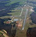
Huntsville Municipal Airport

The Huntsville Municipal Airport is owned by the city. It is a public airport located about 2 nautical miles (4 kilometers) southwest of Huntsville's main business area.
Famous People from Huntsville
- Joe Berry: A professional baseball pitcher. He played for teams like the Chicago Cubs and Cleveland Indians.
- Orval E. Faubus: He was the 36th governor of Arkansas. He lived in Huntsville when he was young.
- Ronnie Hawkins: A famous rockabilly musician. His band, The Hawks, later became the well-known group The Band. He was born in Huntsville.
- Gary Miller: A Republican congressman from California. He was born in Huntsville.
- Isaac Murphy: A politician who lived and worked in Huntsville. He became governor in 1863.
- Danny L. Patrick: A Republican member of the Arkansas House of Representatives. He taught school in Huntsville for several years.
Images for kids
-
Huntsville Municipal Airport from above
See also
 In Spanish: Huntsville (Arkansas) para niños
