Hyōgo Prefecture facts for kids
Quick facts for kids Hyōgo Prefecture |
|||||||||
|
|||||||||
 |
|||||||||
| Capital | Kobe | ||||||||
| Region | Kansai | ||||||||
| Island | Honshu | ||||||||
| Governor | Toshizō Ido | ||||||||
| Area (rank) | 8,396.13 km² (12th) | ||||||||
| - % water | 0.6% | ||||||||
| Population (November 1, 2011) | |||||||||
| - Population | 5582978 (7th) | ||||||||
| - Density | auto /km² | ||||||||
| Districts | 8 | ||||||||
| Municipalities | 41 | ||||||||
| ISO 3166-2 | JP-28 | ||||||||
| Website | |||||||||
| Prefectural Symbols | |||||||||
| - Flower | Nojigiku (Chrysanthemum japonense) | ||||||||
| - Tree | Camphor tree (Cinnamomum camphora) | ||||||||
| - Bird | Oriental white stork (Ciconia boyciana) | ||||||||
| - Fish | |||||||||
 Symbol of Hyōgo Prefecture |
|||||||||
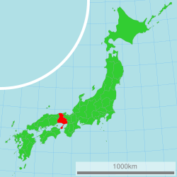
Hyōgo Prefecture is a special area in Japan. It is like a state or province. It is located in the Kansai region on the big island of Honshu. The main city and capital of Hyōgo is Kobe.
Contents
History of Hyōgo
Hyōgo Prefecture was created a long time ago during the Meiji period. This was a time when Japan changed a lot. Different old areas, called provinces, were joined together to form Hyōgo. These provinces included Harima, Tajima, Awaji, and parts of Tamba and Settsu.
In 1993, a very famous castle called Himeji Castle was given a special title. It was named a UNESCO World Heritage Site. This means it is a place that is important for everyone in the world to protect. Himeji Castle is located in the city of Himeji.
In 1995, a big natural event happened. A strong earthquake, known as the Great Hanshin earthquake, hit Kobe and nearby Osaka Prefecture. It caused a lot of damage and sadly, many people lost their lives.
Geography of Hyōgo
Hyōgo Prefecture is unique because it has coastlines on two different seas. To the north, it touches the Sea of Japan. To the south, it borders the Seto Inland Sea. Awaji Island, which is in the Inland Sea, is also part of Hyōgo.
Hyōgo shares its land borders with several other prefectures. These include Osaka Prefecture, Kyoto Prefecture, Tottori Prefecture, and Okayama Prefecture.
Cities in Hyōgo
There are twenty-nine cities in Hyōgo Prefecture. The capital city is Kobe. Here is a list of some of the cities:
|
|
|
National Parks
About 20% of the land in Hyōgo Prefecture is protected as National Parks. These parks help keep nature safe.
Shrines and Temples
Izumo daijinju is a very important Shinto shrine in Hyōgo. Shinto shrines are places of worship in the Shinto religion. Izumo daijinju is known as the chief shrine (or ichinomiya) for the prefecture.
Related pages
- Provinces of Japan
- Prefectures of Japan
- List of regions of Japan
- List of islands of Japan
- Hanshin Tigers
Images for kids
See also
 In Spanish: Prefectura de Hyōgo para niños


