
Inland Waterway (Michigan) facts for kids
Quick facts for kids Inland Waterway |
|
|---|---|
.jpg)
Historic marker within Burt Lake State Park
|
|
| Location | Cheboygan and Emmet counties Michigan |
| Designated | January 19, 1957 |
| Lua error in Module:Location_map at line 420: attempt to index field 'wikibase' (a nil value). | |

The Inland Waterway is a special route of rivers and lakes in Michigan, USA. It is about 38-mile-long (61 km). This waterway lets small boats travel between Lake Huron and Crooked Lake. It goes through the northern part of Michigan.
Even though Little Traverse Bay is very close to Crooked Lake, the waterway does not connect to it. This means you cannot reach Lake Michigan using this route.
The Inland Waterway is found in Emmet and Cheboygan counties. It includes several important lakes and rivers:
The route also goes through or near several towns. These include Conway, Oden, Ponshewaing, Alanson, Indian River, Topinabee, and Cheboygan.
Contents
History of the Inland Waterway
How Native Americans Used the Waterway
Long ago, Native Americans used the Inland Waterway. It helped them avoid the rough waves on Lake Michigan near Waugoshance Point. Because of this, more than 50 Native American camps have been found along the waterway's shores. One camp in Ponshewaing has artifacts that are over 3,000 years old. These items show how people lived there a very long time ago.
Settlement and Changes in the 1800s
In 1873, the Grand Rapids and Indiana Railroad reached Petoskey. This made the area popular for tourists, new settlers, and lumber workers. People started thinking of new ways to use the waterway. One idea was to deliver mail along the route. This required making the Crooked River deeper.
Later, goods were also moved along the waterway. However, trains became a cheaper way to transport things. Because of this, the Inland Waterway was used less and less for shipping.
The Inland Waterway Today
Today, the area around the Inland Waterway is still a popular place for visitors. A group called The Inland Water Route Historical Society was started in 2004. They help preserve the history of the area. They also have a museum in Alanson.
Along the waterway, you can find four state campgrounds and several private ones. There are also hotels for people to stay in. Many marinas offer supplies and fuel for boats.
How the Waterway is Maintained
The waterway is kept at a depth of about five feet (1.5 m). This allows boats to travel safely. There are two special structures called locks, located at Cheboygan and Alanson. There is also a swinging bridge along the route.
The locks can handle boats that are up to 60 feet (18 m) long and 17 feet (5.2 m) wide. The lowest bridge that does not move has a height of 14.7 feet (4.5 m). The locks are open from mid-April to late October.
When crossing Burt Lake, the shortest path is about 6.5 miles (10.5 km). For Mullett Lake, the shortest path is about 10 miles (16 km). On both lakes, boats can be as much as a mile from shore.
Images for kids
-
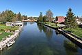
Indian River
-
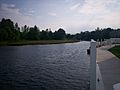
Cheboygan River
-

Alanson swing bridge
-
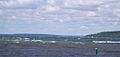
Burt Lake


