Irvinebank facts for kids
Quick facts for kids IrvinebankQueensland |
|||||||||||||||
|---|---|---|---|---|---|---|---|---|---|---|---|---|---|---|---|
 |
|||||||||||||||
| Population | 113 (2021 census) | ||||||||||||||
| • Density | 0.1527/km2 (0.395/sq mi) | ||||||||||||||
| Postcode(s) | 4887 | ||||||||||||||
| Elevation | 750 m (2,461 ft) | ||||||||||||||
| Area | 740.1 km2 (285.8 sq mi) | ||||||||||||||
| Time zone | AEST (UTC+10:00) | ||||||||||||||
| Location | |||||||||||||||
| LGA(s) | Shire of Mareeba | ||||||||||||||
| State electorate(s) | Hill | ||||||||||||||
| Federal Division(s) | Kennedy | ||||||||||||||
|
|||||||||||||||
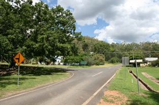
Irvinebank is a small country town and area in the Shire of Mareeba, Queensland, Australia. In 2021, about 113 people lived here. It's known for its history, especially its past as a mining town.
Contents
Geography
The Great Dividing Range is a big mountain range that forms the south and southeast border of Irvinebank.
Irvinebank is located in the western part of the Atherton Tablelands in Far North Queensland. It is about 123 kilometers (76 miles) southwest of Cairns. You can reach it by road from Cairns or from Petford further west.
The area around Irvinebank is generally mountainous. Here are some of the named peaks:
- Billing Knob (805 meters or 2,641 feet)
- Boot Hill (894 meters or 2,933 feet)
- Geebung Hill (896 meters or 2,940 feet)
- Giblets Peak (912 meters or 2,992 feet)
- Hermit Hill (886 meters or 2,907 feet)
- Iron Mountain (886 meters or 2,907 feet)
- Lead Hill (866 meters or 2,841 feet)
- Mount Babinda (827 meters or 2,713 feet)
- Mount Gossan (883 meters or 2,897 feet)
- Mount Misery (1070 meters or 3,510 feet)
History
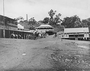
Irvinebank was first called Gibbs Camp. It was founded in 1884 by John Moffat. He bought mining rights from the first people who found minerals there. Moffat built a dam, a mill, and smelters. These helped attract more settlers and miners to the area.
John Moffat was born in Scotland, near a river called Irvine. It is thought he named the town Irvinebank to honor his home. Irvinebank grew into a busy town because of its mining, milling, and smelting activities.
In late 1884, a serious event involving the Native Police and Aboriginal Australians happened near Irvinebank. An investigation was held, and an officer was later dismissed from the Native Police. This event helped change how Indigenous people were treated in the colony.
The Irvinebank Post Office opened on 1 June 1885. A smaller "receiving office" had been open since 1884.
Schools in the Area
Irvinebank Provisional School opened on 27 September 1886. It became Irvinebank State School on 1 August 1890. Other schools also opened and closed in the wider area:
- Montalbion State School opened around 1888 and closed in 1906.
- Stannary Hills Provisional School opened on 18 January 1904. It became Stannary Hills State School in 1907 and closed around 1931.
- Rocky Bluffs Provisional School opened in 1904 and closed in 1910.
- Gurrumba Provisional School opened in 1907 and closed around 1916.
- Hale's Siding Provisional School opened on 22 February 1915 and closed in February 1922.
Irvinebank has always been part of the Shire of Mareeba. For a short time, from 2008 to 2013, it was part of the Tablelands Region. But then the Shire of Mareeba was brought back after people voted for it.
Population Changes
The population of Irvinebank has changed a lot over the years.
- In 1911, the population grew to 1,264 people.
- Ten years later, in 1921, it dropped to 607 people and continued to fall.
- In 2006, there were 311 people living in Irvinebank.
- By 2016, the population was 125 people.
- In 2021, it decreased slightly to 113 people.
Historic Places
Irvinebank has several places that are listed as important heritage sites. These places are protected because of their historical value.
- High Street: Irvinebank State School
- Jessie Street: Queensland National Bank
- Off Jessie Street: Irvinebank State Treatment Works
- 16 O'Callaghan Street: Loudoun House
- Mareeba Mining District: Vulcan Mine
- McDonald Street: Irvinebank School of Arts Hall
- Stannary Hills-Irvinebank Road: Stannary Hills Tramways
Education
Irvinebank State School is a government primary school for students from Prep to Year 6. It is located on High Street. In 2018, the school had 9 students.
There is no high school in Irvinebank. Students usually go to Dimbulah State School or Herberton State School for Years 7 to 10. For Years 11 and 12, the nearest government high school is Atherton State High School in Atherton. Some students might also use distance education or go to boarding schools if they live far away.
Facilities
Irvinebank has a few important facilities for its residents:
- The Irvinebank Post Office is at 16 O'Callaghan Street.
- The Irvinebank Rural Fire Station is on Jessie Street.
- The Irvinebank Cemetery is on Cemetery Road, just southwest of the town.
- The Montalbion Pioneer Cemetery is in the old town of Montalbion. It is no longer used for burials.
Community Places
- The Irvinebank School of Arts is a public hall at 2633 Herberton Petford Road. It has monuments and memorials, including one for John Moffat, the town's founder. There is also a Roll of Honour for those who served in World War I.
- The Irvinebank Tavern is at 2656 Herberton Petford Road. It offers meals, places to stay, and petrol.
Things to See
- The Loudoun House Museum is at 16 O'Callaghan Street, inside the historic Loudoun House. This museum shares the local history of the area. It also has resources for people researching their family history.
Famous People
- Henry Dalziel, who received the Victoria Cross for his bravery in World War I, was born in Irvinebank.


