
Italian Peninsula facts for kids
Quick facts for kids
Italian Peninsula
Apennine Peninsula Penisola italiana, Penisola appenninica, Terraferma, Continente, lo Stivale (Italian) |
|
|---|---|

Satellite view of the peninsula in March 2003.
|
|

Italian Peninsula in dark green
|
|
| Geography | |
| Location | Southern Europe |
| Coordinates | 42°N 14°E / 42°N 14°E 37°N 15°E / 37°N 15°E |
| Area | 150,000 km2 (58,000 sq mi) (44% of Italy's area) |
| Highest point | Corno Grande |
| Administration | |
| Largest settlement | Rome |
| Largest settlement | Dogana |
| Largest settlement | Itself (City-state) |
| Demographics | |
| Demonym | Apennine |
| Population | 26,170,000 |
| Pop. density | 199.27 /km2 (516.11 /sq mi) |
| Ethnic groups | Italian |
The Italian Peninsula, also known as the Apennine Peninsula, is a large piece of land in Southern Europe. It sticks out into the Mediterranean Sea. To its east, you'll find the Ionian Sea and the Adriatic Sea. To its west is the Tyrrhenian Sea.
This peninsula is located between two other big peninsulas: the Iberian Peninsula and the Balkan Peninsula. Because of its unique shape, it's often called Lo Stivale, which means "The Boot" in Italian. Three smaller peninsulas help create this famous boot shape:
- Calabria forms the "toe"
- Salento forms the "heel"
- Gargano forms the "spur"
Contents
Geography of the Italian Peninsula
The Italian Peninsula is about 1,000 kilometers (620 miles) long. It starts from the Po Valley in the north. The Apennine Mountains run almost its entire length, like a backbone.
Most of the peninsula has a Mediterranean climate. This means it usually has hot, dry summers and mild, wet winters. However, in the mountainous areas, the climate is much cooler, especially at higher elevations.
Understanding the Peninsula's Borders
The northern border of the Italian Peninsula has been defined in different ways. Since the time of the Roman emperor Augustus (around the end of the 1st century BC), the northern edge was considered to be the Alps mountain range. This is where the rivers flowing from the Alps begin.
However, if you look at the geography more closely, its northern end is sometimes described differently. It runs from the Magra River to the Rubicon River. These rivers are north of the Apennine Mountains, in the regions of Tuscany and Emilia-Romagna. This geographical definition does not include the large Po Valley or the southern slopes of the Alps.
Countries on the Peninsula
Almost all of the Italian Peninsula is part of the country of Italian Republic. However, there are two other small countries located entirely within the peninsula:
- San Marino: This is a very small country completely surrounded by Italy. It is located in the north-east part of the peninsula.
- Vatican City: This is the smallest independent state in the world. It is an enclave (a country completely surrounded by another country) located within the city of Rome, Italy.
Related Pages
Images for kids
-
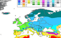
This map shows the different climates in Europe. The Köppen-Geiger climate map helps us see the natural borders of mountain ranges like the Alps, Pyrenees, and Balkans.

See also
 In Spanish: Península itálica para niños
