Joanna, South Carolina facts for kids
Quick facts for kids
Joanna, South Carolina
|
|
|---|---|

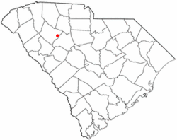
Location of Joanna, South Carolina
|
|
| Country | United States |
| State | South Carolina |
| County | Laurens |
| Area | |
| • Total | 3.14 sq mi (8.14 km2) |
| • Land | 3.14 sq mi (8.13 km2) |
| • Water | 0.01 sq mi (0.01 km2) |
| Elevation | 607 ft (185 m) |
| Population
(2020)
|
|
| • Total | 1,517 |
| • Density | 483.58/sq mi (186.69/km2) |
| Time zone | UTC-5 (Eastern (EST)) |
| • Summer (DST) | UTC-4 (EDT) |
| ZIP code |
29351
|
| Area code(s) | 864 |
| FIPS code | 45-36790 |
| GNIS feature ID | 1246175 |
Joanna is a small community in Laurens County, South Carolina, United States. It is an unincorporated community, meaning it doesn't have its own local government like a city or town. It is also a census-designated place (CDP), which is an area the U.S. Census Bureau defines for gathering population data.
In 2020, about 1,517 people lived in Joanna. It is part of the larger Greenville-Mauldin-Easley Metropolitan Statistical Area.
Contents
History of Joanna
The area where Joanna is located was first settled a long time ago, in the 1760s.
Early Names of the Community
By the 1850s, the community was known as "Martin's Depot". This name honored Martin Kinard, a local farmer who helped bring the Laurens Railroad through the area.
During the American Civil War, on April 30, 1865, Jefferson Davis, who was the president of the Confederate States, passed through the town. He was traveling away from Richmond and spent the night nearby.
In 1872, the town's name changed again to "Goldville".
How Joanna Got Its Name
The name "Joanna" was given to the town in 1948. It was named after the wife of a local industrialist, a person who owned or managed a large business.
Geography of Joanna
Joanna is located in the eastern part of Laurens County, South Carolina.
Roads and Travel
U.S. Route 76 runs along the east side of Joanna. This road can take you about 6 miles (10 km) northwest to Clinton or 14 miles (23 km) to Laurens, which is the main town of the county. If you go southeast on Route 76, you'll reach Newberry, about 16 miles (26 km) away.
Interstate 26 is a major highway that passes about 3 miles (5 km) northeast of Joanna. You can get to it from South Carolina Highway 66.
Land and Water Features
The community of Joanna covers a total area of about 3.14 square miles (8.1 square kilometers). Most of this area is land, with only a very small part, about 0.01 square miles (0.01 square kilometers), being water.
The western part of Joanna reaches towards the upper areas of the Bush River. This river flows southeast and eventually joins the Saluda River. To the east, Joanna extends to Indian Creek, which flows east into the Enoree River and then into the Broad River.
People of Joanna
Understanding the people who live in Joanna helps us learn more about the community.
Population Changes
| Historical population | |||
|---|---|---|---|
| Census | Pop. | %± | |
| 2020 | 1,517 | — | |
| U.S. Decennial Census | |||
According to the census in 2000, there were 1,609 people living in Joanna. By the 2010 census, the population had slightly decreased to 1,539 people. The most recent census in 2020 showed the population was 1,517 people.
Community Life
In 2000, there were 688 households in Joanna. A household is a group of people living together in one home. About 27.5% of these households had children under 18 living with them. Many households were married couples living together.
The average age of people in Joanna in 2000 was 41 years old. The population included people of all ages, from children to seniors. About 23.1% of the population was under 18, and 20.3% was 65 years or older.
See also
 In Spanish: Joanna (Carolina del Sur) para niños

