
Johannesburg Mountain facts for kids
Quick facts for kids Johannesburg Mountain |
|
|---|---|

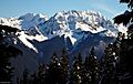
Viewed from Sahale Mountain
|
|
| Highest point | |
| Elevation | 8,200+ ft (2,500+ m) NGVD 29 |
| Prominence | 1,560 ft (480 m) |
| Geography | |
| Location | Skagit County, Washington, U.S. |
| Parent range | North Cascades |
| Topo map | USGS Cascade Pass (WA) |
| Climbing | |
| First ascent | 1938 by Calder Bressler, Bill Cox, Ray Clough, Tom Myers |
| Easiest route | East Route (hike/scramble) |
Johannesburg Mountain is a very famous peak in the North Cascades mountain range. It is located in Washington state, in the United States. Even though it's not one of the tallest mountains in the state, Johannesburg Mountain is known for its incredibly steep sides. Its huge Northeast Face drops over 5,000 feet (1,525 meters) in less than a mile! This makes it a truly impressive sight.
The mountain's name, "Johannesburg Mountain," came from a mistake. It was supposed to be "Johnsberg," which was the name of three mining claims on the mountain's north side. Some people also used to call it "Elsbeth."
Contents
Climbing Johannesburg Mountain
The first time anyone successfully climbed Johannesburg Mountain was on July 26, 1938. The climbers were Calder Bressler, Bill Cox, Ray W. Clough, and Tom Myers. They used a path similar to the most popular route today, called the East Ridge/Cascade-Johannesburg Couloir Route.
Popular Climbing Routes
Most of the popular climbing paths on Johannesburg Mountain are on its south side. These routes are usually considered "scrambling" routes. Scrambling is like a mix between hiking and easy rock climbing. You often use your hands to help you balance and move up.
Challenging Climbing Routes
On the other hand, the north and northeast faces of the mountain have many very difficult climbing routes. These routes are called "technical" climbs. They require special climbing gear and skills. Climbers on these faces also face dangers from falling rocks and ice.
Weather Around Johannesburg Mountain
Johannesburg Mountain is in a special climate zone called the marine west coast climate. This means it gets a lot of moisture from the Pacific Ocean.
How Weather Forms Here
Most weather systems, like big clouds and storms, start over the Pacific Ocean. They then travel northeast towards the Cascade Range. When these weather systems hit the tall peaks of the Cascade Range, they are forced to rise. As the air rises, it cools down and drops its moisture. This causes a lot of rain or snowfall on the western side of the North Cascades. This process is called Orographic lift.
Seasons and Snowfall
Because of this, the western side of the North Cascades gets a lot of precipitation, especially in winter. Most of this winter precipitation falls as heavy snow. Winters are often cloudy, but summers are usually clear and sunny. This is because high-pressure systems form over the Pacific Ocean during the summer. The snow here tends to be wet and heavy. This can make the risk of avalanches higher.
The Geology of the Mountain
The North Cascades is a very rugged area. It has sharp peaks, rocky ridges, deep valleys carved by glaciers, and tall, pointy granite rocks. The amazing landscape we see today was formed by geological events that happened millions of years ago. These events created the big changes in elevation and the different climates across the Cascade Range.
How the Cascades Were Formed
The story of the Cascade Mountains began millions of years ago, during the late Eocene Epoch. At that time, the North American Plate was slowly moving over the Pacific Plate. This movement caused many volcanic eruptions and created new rocks. Also, small pieces of the Earth's crust, called terranes, came together to form the North Cascades about 50 million years ago.
Impact of Glaciers
Over the past two million years, during the Pleistocene period, glaciers played a huge role. These massive ice sheets moved forward and backward many times. As they moved, they scraped and shaped the land, leaving behind piles of rock. The "U"-shaped valleys you see in the area were carved out by these glaciers. The combination of land being pushed up (called uplift) and cracks in the Earth's crust (called faulting), along with the glaciers, created the tall peaks and deep valleys of the North Cascades.
Images for kids
-
Johannesburg Mountain's southwest side

