
Kamay Botany Bay National Park facts for kids
Quick facts for kids Kamay Botany Bay National ParkNew South Wales |
|
|---|---|
|
IUCN Category V (Protected Landscape/Seascape)
|
|

A view across Botany Bay from Inscription Point.
|
|

Kamay Botany Bay National Park
Location in New South Wales
|
|
| Nearest town or city | Kurnell |
| Established | 23 November 1984 |
| Area | 4.56 km2 (1.8 sq mi) |
| Managing authorities | NSW National Parks & Wildlife Service |
| See also | Protected areas of New South Wales |
| Kamay Botany Bay National Park | |
|---|---|
| Lua error in Module:Location_map at line 420: attempt to index field 'wikibase' (a nil value). | |
| Location | Cape Solander Drive, Kurnell, City of Shellharbour, New South Wales, Australia |
| Owner | NSW Office of Environment and Heritage |
| Official name: Kamay Botany Bay: botanical collection sites, Captain Cook Dr, Kurnell, NSW, Australia | |
| Type | Listed |
| Designated | 10 September 2017 |
| Reference no. | 106162 |
| Type | Historic site |
| Place File No | 1/16/035/0034 |
| Official name: Kamay Botany Bay National Park (North and South) and Towra Point Nature Reserve; La Perouse Monument; Tomb of Pere Receveur; Macquarie Watchtower; Cable Station | |
| Type | State heritage (complex / group) |
| Designated | 29 November 2013 |
| Reference no. | 1918 |
| Type | Historic site |
| Category | Aboriginal |
The Kamay Botany Bay National Park is a special protected area and national park in New South Wales, Australia. It's about 16 kilometres (9.9 mi) south-east of Sydney city. The park covers 456 hectares (1,130 acres) on both sides of Botany Bay: the northern part is at La Perouse and the southern part is at Kurnell.
This park is important for its nature, history, and culture. It includes places like the La Perouse Monument and the Macquarie Watchtower. The NSW National Parks & Wildlife Service looks after it. Kamay Botany Bay is listed on both the New South Wales State Heritage Register (since 2013) and the Australian National Heritage List (since 2017). It's also part of a UNESCO World Heritage project.
The park is famous because it's where botanist Sir Joseph Banks and naturalist Dr Daniel Solander collected plants in 1770. This happened when Captain Cook's ship, the Endeavour, first landed in Australia. They found many unique Australian plants, some of which became important "type-specimens" for science.
Contents
Exploring the Park's Past
How the Land Was Formed
Botany Bay sits in a geological area called the Botany Basin. The cliffs you see, especially the Hawkesbury sandstone, were formed millions of years ago. This happened during the Triassic period, between 200 and 250 million years ago.
About 20,000 years ago, during the ice age, the Kurnell headland was a sandstone hill. As sea levels rose over time, areas like seagrass beds and mangrove forests grew. Around 7,400 years ago, the sea stopped rising, and waves shaped the cliffs at Kurnell. The Kurnell area also started to form as mud and sand from the Georges River built up.
Aboriginal History Before Europeans
Evidence shows that Aboriginal people lived in this area about 12,000 years ago. The Dharawal language group lived south of Botany Bay, with the Gweagal clan in the Kurnell area. On the northern side, Cadigal people of the Dharug language group lived.
These groups used the rich resources of the bay, like seafood, reptiles, and mammals. Fishing was a main food source. They made fish hooks from shells and nets from bark. Many local plants were also edible, like fern roots and a spinach-like plant called Warrigal.
Both sides of Botany Bay were important gathering places for ceremonies. At Kurnell, there's a special bora ring for rites and an ochre pit for pigments. Kurnell was likely a semi-permanent home for the Gweagal. There are also carved trees and a women's birthing site, showing how much the area was used.
Aboriginal ancestral remains have been reburied in the park. This is very important for Aboriginal people, as it reunites their ancestors with their traditional land. The La Perouse section also has shell middens and rock engravings, showing daily life before European arrival.
Captain Cook's Arrival in 1770
Before April 29, 1770, the Dharawal people saw a "white bird" or floating island, which was Captain James Cook's Endeavour. The ship entered Botany Bay and anchored near a small village of bark huts on the southern shore, now known as Silver Beach.
When Cook and his men tried to land, two Gweagal warriors tried to stop them with spears. Cook ordered muskets to be fired, and one warrior was hit. The warriors then retreated but continued to ignore the British. This was their way of showing that visitors should wait for an invitation.
For eight days, Cook's crew explored the area. They found a stream near the village to refill their water supplies. This spot is now called Captain Cook's Landing Place.
Sir Joseph Banks and Daniel Solander, a student of Carolus Linnaeus, collected many new plant and animal specimens. They found plants like the Banksia, named after Joseph Banks. Cook named the bay "Botany Bay" because of their important work. Every specimen was sketched by Sydney Parkinson and later published in Banks' Florilegium.
The First Fleet Arrives in 1788
On January 18, 1788, Governor Arthur Phillip arrived at Botany Bay with the First Fleet. They planned to start the first British settlement here. Phillip was disappointed by the lack of fresh water and the large number of Aboriginal people. By January 26, 1788, Phillip left Botany Bay and sailed to Port Jackson, where the first settlement in Australia was made.
The French Expedition of Laperouse
Around the same time, a French expedition led by Jean-Francois Galaup de Laperouse arrived at Botany Bay on January 24, 1788. Their ships, La Boussole and Astrolabe, anchored near Frenchman's Beach.
One of their team, Pere Receveur, a priest and naturalist, died on February 17, 1788. He was the first French person buried on the mainland. A tomb was built over his grave in 1829. The French stayed for six weeks, repairing their ships and conducting scientific experiments.
After Phillip and Laperouse left, the Kurnell headland remained quiet for a while. The La Perouse area also stayed mostly unsettled until the 1860s. However, European arrival brought diseases like smallpox, which greatly affected the Aboriginal people.
Growth of La Perouse (19th & 20th Century)
By 1830, the northern part of the park at La Perouse was a government reserve. Troops were stationed there to watch for ships and stop smuggling. In 1822, they lived in "Macquarie's Tower," a sandstone watchtower. This tower later became accommodation for a caretaker looking after the Laperouse Monument and Pere Receveur's tomb. These monuments are still visited by French people today.
In 1876, an underwater telegraph cable came ashore at La Perouse. A brick Cable Station was built in 1881, which is now the La Perouse Museum.
Many Aboriginal people who had left the area started to return in the 1870s. By 1881, there were two camps with Aboriginal people living there. The government even built huts for them.
In 1881, a smallpox outbreak led to an isolation hospital being built at Little Bay, which became Prince Henry Hospital. The Coast Hospital Cemetery, now part of the park, was used for burials, including many Aboriginal people. It's an important reburial site for the local Aboriginal community.
An Anglican Aboriginal mission was set up in 1885, and a church was built in 1894. The camp at Frenchmans Bay became an Aboriginal reserve in 1895. People living there worked as fishermen or made crafts for tourists.
During the Great Depression, a shanty town called Happy Valley grew behind Congwong Beach. People built homes from whatever they could find. In 1939, the town was cleared, and residents moved to better housing. The La Perouse Aboriginal community remains strong and established today.
Growth of Kurnell (19th & 20th Century)
In 1815, Governor Macquarie granted land at Kurnell to James Birnie, who started a farm. Later, John Connell bought the farm and eventually owned most of the Kurnell peninsula. His grandson, John Jr., cleared much of the land for timber.
In 1861, Thomas Holt, a wealthy wool merchant, took over the land. He tried oyster farming, raising sheep, and even coal mining, with help from many employees, including Aboriginal people. However, these businesses weren't very successful.
By 1881, Holt started selling off parts of the estate. Some unsold areas within the current national park became a public reserve in 1899. This reserve was managed by a trust.
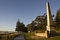
Captain Cook's Landing Place became a popular spot for visitors interested in history. In 1870, Thomas Holt built Cook's Obelisk. A wharf was built, and a steam ferry started bringing visitors. The trust also erected the Solander Obelisk in 1918 and the Banks Memorial in 1947.
After WWII, the Kurnell area became a popular holiday spot for campers. Families set up semi-permanent camps. This continued until 1977 when the NSW National Parks and Wildlife Service took over and stopped the camping.
Like La Perouse, Kurnell also had a shanty town in the cliff overhangs at Cape Solander. These simple homes were used by fishermen and others until the 1960s.
Aboriginal people from La Perouse kept strong ties to Kurnell. They would travel by ferry to fish, swim, and find bush foods. Sonny Simms, who grew up in La Perouse, remembered how important the bay's resources were for his family. Mangrove wood was used for boomerangs, and shells for crafts.
The large sand dunes at Kurnell, with their freshwater ponds, were also important. However, much of the dunes were damaged by sand mining in the 1960s and 1970s due to Sydney's building boom.
In 1967, the Kurnell reserve was given to the National Parks and Wildlife Service. The Botany Bay National Park was officially created in 1988. The park now works to share both Aboriginal and European history. For example, the Commemoration Day ceremony was renamed the "Meeting of Cultures" ceremony, involving local Aboriginal elders.
What You Can See in the Park
The Kamay Botany Bay National Park covers about 492 hectares (1,220 acres). It includes the northern and southern sandstone headlands of Botany Bay. The park also includes the Towra Point Nature Reserve, a 386.4 hectares (955 acres) wetland area.
Northern Section: La Perouse

The northern part of the park is about 168 hectares (420 acres). It includes Cape Banks, Henry Head, Congwong Beach, and the La Perouse Headland. The coast has rocky sandstone cliffs, showing layers of Hawkesbury sandstone.
The park has over 350 plant species, including rare ones. Common plants include Banksia ericifolia, prickly tea tree, and paperbark. Some plant communities, like the Eastern Suburbs Banksia Scrub, are endangered. This area also attracts over 70 bird species, possums, flying foxes, bats, and snakes.
The La Perouse Headland has many historic sites:
- Macquarie Watchtower: A two-story, octagonal sandstone tower, about seven metres (twenty-three feet) tall. It was built around 1811 as a military lookout.
- Former Cable Station (now La Perouse Museum): A two-story brick building that once housed the overseas telegraphic cable.
- Laperouse Monument: An obelisk with a brass astrolabe on top, honoring the French expedition.
- Pere Receveur's Grave: The burial site of the French priest and naturalist.
- Coast Hospital Cemetery: Now called the Dharawal Resting Place, it's an important burial and reburial site for Aboriginal people. It holds an estimated 3,000 burials.
Southern Section: Kurnell
The southern part of the park covers about 324 hectares (800 acres) on the Kurnell Peninsula. The "Meeting Place" area, about 20 hectares (49 acres), is very important.
The Meeting Place has many Aboriginal heritage items, like shell middens and a bora ring. It also has monuments to Cook, Solander, Banks, and Forby Sutherland (a crew member who died). Alpha House, built in 1902, is also here.
An important feature is the stream that flows into Botany Bay. This is where Cook's party refilled their water. This area has high archaeological potential.
The southern part also has 40-metre (130 ft) high Hawkesbury sandstone cliffs at Cape Solander, with deep gorges. Further south, there are sand dunes. The vegetation includes Kurnell dune forest, dry eucalypt forest, and heathlands.
Rare plants like Banksia robur are found here. The park is home to endangered animals like the green and gold bell frog and the tinkling froglet. Many bird species, including the threatened powerful owl and little tern, also live here.
Towra Point Nature Reserve
This reserve is a Ramsar listed wetland of 386 hectares (950 acres). It's important for Aboriginal reburial sites and evidence of past occupation. The area has rare plant communities like coastal banksia woodlands, littoral rainforest, and saltmarshes.
Towra Point is vital for local and migrating wading birds. It's the second most important breeding site for the little tern and the only one in Sydney. Other threatened birds like the pied oyster catcher and peregrine falcon also live here.
Park Features
At the Kurnell Peninsula part of the park, you'll find many memorials and a coast walk. There's also an information center and a museum. The park has high points like Botany Cone (55 metres (180 ft) above sea level) and Long Nose (101 metres (331 ft) above sea level). You can find many walking tracks and lookouts, like the one at Yena Track, which is popular for whale watching. The Cape Bailey Light, a lighthouse built in 1950, is also in the park.
Why This Park is Special
Kamay Botany Bay National Park and Towra Point Nature Reserve are incredibly important for New South Wales. They show the long history of people living on Australia's east coast. The park has clear evidence of Aboriginal life before Europeans arrived and tells the story of how Indigenous and non-Indigenous Australia began. It's where Captain Cook first landed and claimed the land for Britain. It also shows the history of Aboriginal resistance and the impact of European settlement.
Aboriginal people have strong connections to this land. The Gweagal warriors who resisted Cook are symbols of Aboriginal strength. The park also has two important reburial sites for ancestral remains, which are very significant for the Aboriginal community.
The park is also linked to famous European explorers and scientists like James Cook, Joseph Banks, Daniel Solander, Comte de Laperouse, and Pere Receveur. It's also connected to the First Fleet and Governor Arthur Phillip.
Banks and Solander's plant collection in 1770 was a huge scientific achievement. They found many new species, which helped create the Linnaean classification system. Past archaeological digs show that the park has a lot of potential for finding more historical information.
Kamay Botany Bay National Park is beautiful, with its landmark headlands and historic monuments. It's a valuable place for research into Aboriginal history, natural history, and early settlement.
The park also protects rare plants and animals, making it a key part of NSW's efforts to save its biodiversity. The La Perouse section shows the history of French exploration and still has strong ties to the French community today.
This park is unique because it's where British colonizers first landed in Eastern Australia, marking the meeting of Indigenous and European cultures. It contains rare plants and animals, like the Eastern Suburbs Banksia Scrub, littoral rainforest, and endangered birds and frogs. It's a vital link in the network of parks that protect NSW's natural world.
The park also shows how Indigenous people lived before Europeans arrived. The plant communities here are similar to what would have been seen from Sydney Cove to Port Hacking long ago. Finally, Kamay Botany Bay National Park is a great example of a place with many memorials celebrating important historical events, like the meeting of cultures, Cook's exploration, and the scientific work of Banks and Solander.
Images for kids
-
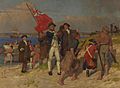
Cook landing with his crew
-
Captain Cooks Landing Place Reserve, a New South Wales State Heritage Register
-
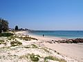
Silver Beach

.jpg)

See also
 In Spanish: Parque nacional Kamay Bahía Botany para niños
