
Keytesville, Missouri facts for kids
Quick facts for kids
Keytesville, Missouri
|
|
|---|---|

Location of Keytesville, Missouri
|
|
| Country | United States |
| State | Missouri |
| County | Chariton |
| Incorporated | 1868 |
| Named for | James Keyte |
| Area | |
| • Total | 0.78 sq mi (2.02 km2) |
| • Land | 0.77 sq mi (1.99 km2) |
| • Water | 0.01 sq mi (0.03 km2) |
| Elevation | 702 ft (214 m) |
| Population
(2020)
|
|
| • Total | 440 |
| • Density | 572.17/sq mi (220.93/km2) |
| Time zone | UTC-6 (Central (CST)) |
| • Summer (DST) | UTC-5 (CDT) |
| ZIP code |
65261
|
| Area code(s) | 660 |
| FIPS code | 29-38468 |
| GNIS feature ID | 2395525 |
Keytesville is a small city in Chariton County, Missouri, United States. It is the main town where the county government is located, also known as the county seat. In 2020, about 440 people lived there.
Keytesville is famous for being the hometown of U.S. Army General Maxwell D. Taylor. He led the "Screaming Eagles" 101st Airborne division during the Normandy invasion in World War II. Also, Confederate General Sterling Price, who attacked Keytesville during the American Civil War, once ran a hotel in the city.
Contents
History of Keytesville

The town of Keytesville is named after James Keyte. He was an Englishman and a Methodist preacher. In 1830, he bought a large piece of land. Two years later, he gave 50 acres of it to Chariton County. This land was used to create the county government's main office.
Before Keytesville, county business happened in "Old Chariton." This village was near the Chariton and Missouri Rivers. However, it had many mosquitoes and often flooded.
James Keyte built the very first home and business in Keytesville. Both were simple log buildings. His business also served as the town's first post office. He also started the town's first industry. He built a mill near his home on Mussel Fork Creek.
The first courthouse in Keytesville was built between 1833 and 1834. It was a two-story brick building with four rooms. Sadly, it was burned down on September 20, 1864. This happened during the American Civil War by Confederate raiders.
Keytesville officially became a town on February 3, 1868. The state of Missouri recognized it. Later, in March 1883, it became a Missouri 4th-class city.
The Confederate Attack
On September 20, 1864, Confederate General Sterling Price came to Keytesville. He had about 250 soldiers with him. This attack was part of Price's larger plan to raid across Missouri.
Keytesville was defended by a small group of 35 Union soldiers. Their leader was Lieutenant Anthony Pleyer. Many local people actually supported the Confederate side.
Early that morning, the Confederates asked the Union troops to surrender. They promised fair treatment. Lieutenant Pleyer could not convince his men to fight, so he surrendered. The Confederate forces then took over the town for a short time. They took supplies from stores. They also burned down the courthouse.
Keytesville in the Late 1800s
In 1866, a new courthouse was planned. It was a two-story brick building with a dome on top. It cost $40,000 to build. This courthouse served the county until it was destroyed by fire in 1973.
By the mid-1890s, Keytesville had about 1,100 people. It had two newspapers, the Chariton Courier and Keytesville Signal. There were also many businesses. These included a large water-powered mill, two banks, and two hotels.
Keytesville was about 1.5 miles north of the Wabash Railroad line. To help businesses, a streetcar line was built in 1889. It had two miles of track and a large barn for horses. Two horse-drawn passenger cars and a freight car carried people and goods from the train station to the town.
Keytesville Today
Today, Keytesville has a business area and a public library. It also has a swimming pool, a bank, and a medical clinic. There are various community groups, like the Lions Club.
Three places in Keytesville are listed on the National Register of Historic Places. These are the First Presbyterian Church, the Chariton County Jail and Sheriff's Residence, and the Redding-Hill House. Price Park has a statue of Sterling Price. A new Chariton County Courthouse was built in 1974.
Education

The Keytesville R-III School district serves the town and nearby areas. Education in the community started before the Civil War. However, old records were lost in a fire in 1861.
In 1889, a large, modern-style school was built. It was a two-story building and cost $13,000. By 1909, Keytesville school was considered a top school in Missouri.
In 1949, many smaller rural schools joined with Keytesville. This created the school district we know today. The current high school was built in 1959. The elementary school was added in 1967.
In 2010, the district had 153 students from kindergarten to 12th grade. About 90% of students graduated. The school mascot is the Tiger. The school colors are black and gold. Keytesville sports teams compete in the Carroll-Livingston Activities Association.
Geography
Keytesville is located where U.S. Route 24 and Missouri Route 5 meet. It is about 10 miles east of Brunswick. It is also about 30 miles west of Moberly.
The city covers a total area of about 0.78 square miles (2.02 square kilometers). Most of this area is land. Only a very small part is water.
Population Changes
| Historical population | |||
|---|---|---|---|
| Census | Pop. | %± | |
| 1870 | 529 | — | |
| 1880 | 737 | 39.3% | |
| 1890 | 819 | 11.1% | |
| 1900 | 1,127 | 37.6% | |
| 1910 | 963 | −14.6% | |
| 1920 | 872 | −9.4% | |
| 1930 | 738 | −15.4% | |
| 1940 | 854 | 15.7% | |
| 1950 | 733 | −14.2% | |
| 1960 | 644 | −12.1% | |
| 1970 | 730 | 13.4% | |
| 1980 | 689 | −5.6% | |
| 1990 | 564 | −18.1% | |
| 2000 | 533 | −5.5% | |
| 2010 | 471 | −11.6% | |
| 2020 | 440 | −6.6% | |
| U.S. Decennial Census | |||
In 2010, there were 471 people living in Keytesville. There were 225 households. About 42% of households were married couples. About 40% of households were single individuals. The average age of people in the city was 46.4 years old.
Notable People from Keytesville
- Jane Hadley Barkley, wife of U.S. vice president Alben Barkley
- Cal Hubbard, a famous athlete in both the Pro Football Hall of Fame and the National Baseball Hall of Fame and Museum
- Sterling Price, a Missouri governor and Confederate general
- Maxwell D. Taylor, a U.S. Army general and diplomat
Images for kids
-
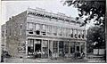
A portion of the Keytesville business district in 1896
-
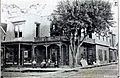
Sneed's Hotel, Keytesville, 1896
-
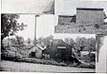
Big Spring Distillery, Keytesville, Missouri. Makers of "Old Chariton Rye" and "Ole Kentuck" whiskey, 1896
-
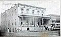
Hotel Snyder, Keytesville. Note the horse-drawn streetcar in the right corner, part of Keytesville's streetcar rail system


See also
 In Spanish: Keytesville (Misuri) para niños
