
King Range (California) facts for kids
Quick facts for kids King Range |
|
|---|---|
.jpg)
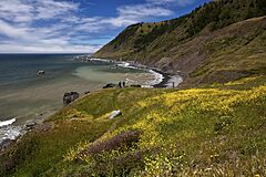
Beach & surf, King Range National Conservation Area
|
|
| Highest point | |
| Peak | King Peak |
| Elevation | 4,091 ft (1,247 m) |
| Geography | |

Location in California

Location in the United States
|
|
| Country | United States |
| State | California |
| County | Humboldt County |
| Range coordinates | 40°09′54.506″N 124°08′3.141″W / 40.16514056°N 124.13420583°W |
| Topo map | USGS Shubrick Peak |
The King Range is a group of mountains found along the coast in Humboldt County, California. It's part of the bigger California Coast Ranges system. This area is famous for its wild, undeveloped coastline, often called the "Lost Coast."
Contents
Geography of the King Range
Much of the King Range is protected. It includes the King Range National Conservation Area and the King Range Wilderness Area. These special places are managed by the Bureau of Land Management (BLM). They help keep the natural beauty and wildlife safe.
The King Range mountains run right next to the Pacific Ocean. Their western sides drop very steeply down to the water.
This area is close to the Mendocino Triple Junction. This is where three huge pieces of Earth's crust, called tectonic plates, meet. They are the Pacific Plate, the North American Plate, and the Juan de Fuca Plate. Because of this, the area often has earthquakes.
Most mountains here are not super tall. King Peak is the highest point, reaching about 4,091 feet (1,247 m) high. Snow falls on the higher parts of the mountains a couple of times each year.
Climate in the King Range
The King Range has a mild climate. Winters are wet with lots of rain, especially in December and January. Summers are much drier and warmer. The weather changes as you go from the coast up into the mountains.
| Climate data for King Range Crests, California | |||||||||||||
|---|---|---|---|---|---|---|---|---|---|---|---|---|---|
| Month | Jan | Feb | Mar | Apr | May | Jun | Jul | Aug | Sep | Oct | Nov | Dec | Year |
| Mean daily maximum °F (°C) | 47 (8) |
48 (9) |
49 (9) |
52 (11) |
57 (14) |
63 (17) |
73 (23) |
74 (23) |
72 (22) |
62 (17) |
50 (10) |
46 (8) |
58 (14) |
| Mean daily minimum °F (°C) | 36 (2) |
35 (2) |
36 (2) |
37 (3) |
41 (5) |
46 (8) |
54 (12) |
55 (13) |
52 (11) |
47 (8) |
39 (4) |
36 (2) |
43 (6) |
| Average precipitation inches (mm) | 34.7 (880) |
29.7 (750) |
28.7 (730) |
13 (330) |
5.5 (140) |
1.4 (36) |
0.1 (2.5) |
0.1 (2.5) |
1.0 (25) |
8.2 (210) |
18.4 (470) |
40.0 (1,020) |
180.8 (4,596) |
| Source: Prism | |||||||||||||
Plants and Animals of the King Range
The King Range is part of the Northern California coastal forests area. It has many trees like coast Douglas-fir, different kinds of oak trees, and tanoak. You can also find Sugar Pine trees on steep slopes above the fog.
Rivers and streams like the Mattole River flow through the range. These waters are home to special fish. Four types of animals here are considered endangered. This means they are at risk of disappearing forever. These include the Coho Salmon, Chinook Salmon, steelhead, and the northern spotted owl.
Other animals you might see include northern elephant seals, harbor seals, and gray whales in the ocean. On land, there are brown pelicans, bald eagles, peregrine falcons, black-tailed deer, mountain lions, bobcats, ospreys, otters, gray foxes, and black bears.
History of the King Range
Long ago, the King Range was home to Native American groups like the Mattole and Sinkyone peoples. In the 1800s, people started using the area for things like cutting down trees (logging), catching fish (fishing), raising animals (ranching), and making leather (tanning).
In the 1930s, engineers were trying to build a new road, California State Route 1. But the King Range was too rough and steep to build the road right along the coast. So, they had to move the highway further inland. Because of this, the coastal area here remained wild and undeveloped. It became known as the Lost Coast. It's the longest stretch of undeveloped coast in California.
In 1970, the U.S. Congress decided to protect about 60,000 acres (240 km2) of the range. They called it the King Range National Conservation Area. It's mostly in Humboldt County, but a small part goes into Mendocino County.
In 2000, President Bill Clinton signed a law to protect the rocks and islands just offshore. These became part of the California Coast National Monument.
Later, in 2006, the U.S. Congress set aside another 42,585 acres (172.34 km2) within the National Conservation Area. This became the King Range Wilderness. A walking path called the California Coastal Trail runs all the way through the range.
Images for kids
-

Wildflowers
-
King Range cove
-
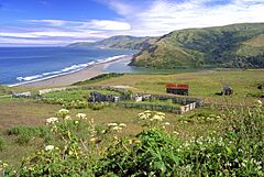
Old ranch and estuary
-

Purple sea urchins and Giant Green anemones, King Range tidepool

.jpg)
.jpg)
.jpg)
