Kobble Creek facts for kids
Quick facts for kids Kobble CreekQueensland |
|||||||||||||||
|---|---|---|---|---|---|---|---|---|---|---|---|---|---|---|---|

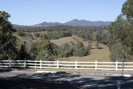
Looking across Kobble Creek towards Mount Samson
|
|||||||||||||||
| Population | 654 (2021 census) | ||||||||||||||
| • Density | 12.601/km2 (32.64/sq mi) | ||||||||||||||
| Postcode(s) | 4520 | ||||||||||||||
| Area | 51.9 km2 (20.0 sq mi) | ||||||||||||||
| Time zone | AEST (UTC+10:00) | ||||||||||||||
| Location |
|
||||||||||||||
| LGA(s) | City of Moreton Bay | ||||||||||||||
| State electorate(s) | Pine Rivers | ||||||||||||||
| Federal Division(s) | Dickson | ||||||||||||||
|
|||||||||||||||
Kobble Creek is a small rural area in the City of Moreton Bay, Queensland, Australia. It's a quiet place where people live, often with some farming or large properties. In 2021, about 654 people called Kobble Creek home.
Contents
Exploring Kobble Creek's Location
Kobble Creek is located along Mount Samson Road. It's south of a town called Dayboro. If you're in the Brisbane central business district, Kobble Creek is about 45 kilometers (28 miles) to the northwest.
Mountains and Natural Features
The south-eastern edge of Kobble Creek is bordered by the Mount Samson Range. This range includes a peak called Mount Kobble. Mount Kobble stands at 384 meters (1,260 feet) tall. The name "Kobble" comes from an old local language, meaning "carpet snake."
A large part of the western area of Kobble Creek is mountainous. This area is part of the D'Aguilar National Park. This national park stretches out into other nearby areas too.
Land Use in Kobble Creek
The eastern part of Kobble Creek is used for different things. Some areas have homes on large blocks of land, which is called rural residential. Other parts are used for grazing animals on natural grass. There is also some farming where crops are grown.
A Look Back at Kobble Creek's History
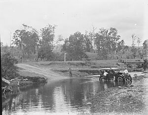
Kobble Creek gets its name from the creek that flows through the area. This creek is important because it helps fill Lake Samsonvale. Lake Samsonvale is one of the main places that supplies water to the big city of Brisbane.
Farming Life in the Past
Years ago, Kobble Creek was mostly a farming community. Many people were dairy farmers, raising cows for milk. Some farmers also grew bananas and pineapples on the hillsides. The community had a butter factory, a primary school, and a railway station. These were all important places for the farmers.
Changes Due to the Dam
A big change happened when the government decided to build the North Pine Dam. To do this, they needed to buy a lot of the best farming land. This land was then flooded to create Lake Samsonvale. Because of this, there isn't much farming in Kobble Creek today. Now, it's mostly a place where people live and travel to work in other areas.
The Old School House
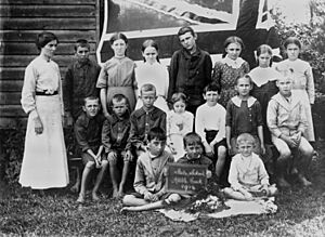
Kobble Creek had a school that opened around 1881. It was first called Kobble Creek Provisional School. Later, in 1909, it became Kobble Creek State School. Sometimes, people spelled it "Cobble Creek State School." The school closed its doors in 1954. Its old location was at 14 Greensill Lane.
The Railway Arrives
In 1919, a railway line called the Dayboro railway line reached Kobble Creek. The Kobble railway station opened on November 3, 1919. The railway line continued to its final stop in Dayboro in 1920.
Official Naming of Kobble Creek
Kobble Creek was officially given its name and boundaries as a locality in June 2009. Before that, it was considered part of the Samsonvale district.
Who Lives in Kobble Creek?
Let's look at the people who live in Kobble Creek.
Population Numbers
- In 2011, there were 499 people living in Kobble Creek.
- In 2016, the population grew to 632 people.
- By 2021, Kobble Creek had a population of 654 people.
A Closer Look at the Residents
In 2011, about 48.7% of the people were female and 51.3% were male. The average age of people in Kobble Creek was 39 years old. This was two years older than the average age for all of Australia.
Most people (77.8%) living in Kobble Creek were born in Australia. Other countries where people were born included England (6.8%), New Zealand (3.4%), South Africa (0.8%), Canada (0.6%), and Cyprus (0.6%).
When it came to languages spoken at home, 92.6% of people spoke only English. A few other languages were spoken, like German (0.6%) and some American Languages (0.6%).
 | Anna J. Cooper |
 | Mary McLeod Bethune |
 | Lillie Mae Bradford |


