Samsonvale, Queensland facts for kids
Quick facts for kids SamsonvaleQueensland |
|||||||||||||||
|---|---|---|---|---|---|---|---|---|---|---|---|---|---|---|---|

Samsonvale & Districts Public Hall, 2020
|
|||||||||||||||
| Population | 674 (2021 census) | ||||||||||||||
| • Density | 19.94/km2 (51.6/sq mi) | ||||||||||||||
| Established | 1845 | ||||||||||||||
| Postcode(s) | 4520 | ||||||||||||||
| Area | 33.8 km2 (13.1 sq mi) | ||||||||||||||
| Time zone | AEST (UTC+10:00) | ||||||||||||||
| Location |
|
||||||||||||||
| LGA(s) | City of Moreton Bay | ||||||||||||||
| State electorate(s) | Pine Rivers | ||||||||||||||
| Federal Division(s) | Dickson | ||||||||||||||
|
|||||||||||||||
Samsonvale is a quiet, rural area in Queensland, Australia. It's part of the City of Moreton Bay. In 2021, about 674 people lived there.
Contents
What is Samsonvale Like?
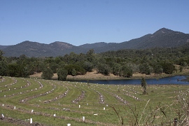
Samsonvale is mostly known for Lake Samsonvale. This big lake is actually the water held back by the North Pine Dam, which helps supply drinking water to a large city area. The area also sits below Mount Samson, which is the highest mountain nearby.
A Look at Samsonvale's History
Long ago, the Indigenous people lived in the Samsonvale area. They called this land Tukuwompa.
British settlers arrived in 1845. The Joyner family started a large farm called the Samsonvale pastoral run. The area was named after this farm. You can find another nearby place called Joyner, which is named after this family.
Over the years, parts of the Joyner family's original farm were taken for other uses. About three-quarters of their land was taken in the 1860s.
Early Schools and Churches
A small school, Samsonvale Provisional School, opened on June 1, 1875. It closed five years later in 1880. It was located near where the Presbyterian Church would later be built.
Church services for the Presbyterian community first took place in the school building. After the school closed, local people worked together to build their own church. They used timber from the area. The church opened on January 25, 1885. It was built on land given by the Gold family.
The church was updated in 1913. However, many people moved away from the area after 1957 because of the North Pine Dam project. The church closed in 1969 and was taken down in 1973. A special memorial now marks where it once stood.
The Railway and Dam's Impact
In 1918, a railway line reached Samford. This line later went all the way to Dayboro in 1920. But in 1955, the railway line from Ferny Grove to Dayboro closed. Today, the closest train station is Ferny Grove, which is part of the City of Brisbane's train network.
Later, in the 1970s, many farming families in Samsonvale had to move again. This was because the North Pine Dam was being built, and the area where Lake Samsonvale now sits was going to be flooded. The flooding of the lake also caused the closure of the Presbyterian Church, the community hall, and the post office.
Today, much of the old Samsonvale village is underwater. All that remains of the old village is a cemetery. The original Samsonvale farm and much of the best farming land are now covered by the lake.
The Samsonvale Rural Fire Brigade building now stands where the center of the Kobble Creek community used to be.
Lake Samsonvale's Water Levels
In 2006, during a very dry period, the water levels of Lake Samsonvale dropped very low. People thought about doing archaeological work to save old items from the flooded farms that dated back to the 1800s. However, by 2010, Lake Samsonvale was full of water again, covering these historical sites once more.
Who Lives in Samsonvale?
In 2011, Samsonvale had 555 people living there. The average age was 38 years old. Most people (83.8%) were born in Australia. Other countries of birth included England (6.1%) and New Zealand (1.8%). Most people (94.2%) spoke only English at home.
By 2016, the population grew slightly to 590 people. In 2021, the population was 674 people.
What to See in Samsonvale
The area around the cemetery is a great place for nature lovers. More than 250 different types of birds have been seen there!
 | Mary Eliza Mahoney |
 | Susie King Taylor |
 | Ida Gray |
 | Eliza Ann Grier |


