Mount Samson, Queensland facts for kids
Quick facts for kids Mount SamsonQueensland |
|||||||||||||||
|---|---|---|---|---|---|---|---|---|---|---|---|---|---|---|---|
 |
|||||||||||||||
| Population | 625 (2021 census) | ||||||||||||||
| • Density | 33.97/km2 (88.0/sq mi) | ||||||||||||||
| Postcode(s) | 4520 | ||||||||||||||
| Area | 18.4 km2 (7.1 sq mi) | ||||||||||||||
| Time zone | AEST (UTC+10:00) | ||||||||||||||
| Location |
|
||||||||||||||
| LGA(s) | City of Moreton Bay | ||||||||||||||
| State electorate(s) | Pine Rivers | ||||||||||||||
| Federal Division(s) | Dickson | ||||||||||||||
|
|||||||||||||||
Mount Samson is a quiet area in Queensland, Australia. It is part of the City of Moreton Bay. In 2021, about 625 people lived there.
Contents
Where is Mount Samson?
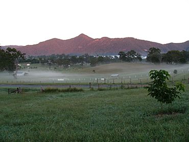
Mount Samson is located in South East Queensland. It sits between the towns of Samford and Dayboro.
It is about 34 kilometers (21 miles) northwest of Brisbane. This is a major city in Queensland.
The area has many large properties and small farms. In the past, it was mostly used for farming, especially dairy. You can get to Mount Samson from Brisbane by using Samford Road and Mount Samson Road.
What is the history of Mount Samson?
The local Indigenous people called this area Buran (Boorun). This name means "wind."
The name Mount Samson comes from a nearby mountain. This mountain is part of the D'Aguilar Range.
Schools in the area
Samson Creek Provisional School first opened on August 9, 1880. It became Samson Creek State School on October 1, 1909. In 1925, the school moved to a new spot. It was then renamed Mount Samson State School.
Train service
Mount Samson had a train service to Brisbane from 1919 to 1955. The train station was next to where Samsonvale Hall is today.
Music festival
From 2009 to 2017, Mount Samson hosted an annual music festival. It was called the Red Deer Festival.
How many people live in Mount Samson?
The number of people living in Mount Samson has slowly grown.
- In 2011, there were 566 people.
- In 2016, the population was 594 people.
- In 2021, 625 people lived in Mount Samson.
Most people living here were born in Australia. Others came from countries like England and New Zealand.
What is the climate like?
Mount Samson has a sub-tropical climate. This means it has very hot and humid summers. The winters are mild, dry, and sunny.
Most of the rain falls during the summer months. This is usually between November and February. Summer temperatures often reach around 30°C (86°F). However, some days can be much hotter, even up to 40°C (104°F).
What facilities are in Mount Samson?
Samsonvale Hall is a community building. It is located on Winn Road, across from the primary school.
The Moreton Bay City Council also provides a mobile library service. This library visits the Mount Samson State School on Winn Road.
Education in Mount Samson
Mount Samson State School is a government primary school. It teaches students from Prep to Year 6. The school is located at 1060 Winn Road.
In 2017, the school had 313 students. It also had 26 teachers. The school offers a special education program.
Some people call it a "school without a town." This is because it serves students from nearby areas, but there isn't a town center right around it. Even so, the school community is very close and supportive.
Right in front of the school, you'll find Sparrow Early Learning. This is a childcare center for babies up to school-aged children. There is also Songbirds, a small music learning center.
 | William M. Jackson |
 | Juan E. Gilbert |
 | Neil deGrasse Tyson |


