
Kotelny Island facts for kids

Location of Kotelny Island in the Russian Federation
|
|

Kotelny
Location in Sakha Republic
|
|
| Geography | |
|---|---|
| Location | East Siberian Sea |
| Coordinates | 75°20′N 141°00′E / 75.333°N 141.000°E |
| Archipelago | New Siberian Islands |
| Total islands | 7 |
| Major islands | 3 |
| Area | 23,165 km2 (8,944 sq mi) |
| Highest elevation | 361 m (1,184 ft) |
| Highest point | Malakatyn-Tas |
| Administration | |
|
Russia
|
|
| Republic | Yakutia |
| Demographics | |
| Population | 250 (2017) |
| Pop. density | 0.000086 /km2 (0.000223 /sq mi) |
| Ethnic groups | None |
Kotelny Island (Russian: Остров Котельный, Ostrov Kotelny) is a large island in the Russian Arctic. It is part of the New Siberian Islands group. You can find it between the Laptev Sea and the East Siberian Sea. This island is part of the Sakha Republic (Yakutia) in Russia.
Many maps from the 1900s show Kotelny, Faddeyevsky, and Bunge Land as separate islands. However, on newer maps, the name "Kotelny" often refers to the entire landmass. A flat, low-lying area called Bunge Land connects these parts.
Kotelny Island covers a huge area of 23,165 square kilometers. This makes it one of the 50 largest islands in the world!
Contents
Exploring Kotelny Island's Past
A Russian merchant and hunter named Ivan Lyakhov officially discovered Kotelny Island in 1773. He was with another merchant, Protod’yakonov. A few years earlier, in 1770, Ivan Lyakhov saw reindeer tracks leading out over the sea ice. Following these tracks in 1773, they first found the Lyakhovsky Islands. Then, they continued and discovered Kotelny Island.
They named it "Kettle Island" because they found a copper kettle there. No one knows who left the kettle behind. Before this, some maps called it "Thaddeus Island."
Between 1800 and 1810, Yakov Sannikov led many hunting and map-making trips. On one trip in 1805, he discovered Faddeyevsky Island. Later, in 1809–1810, Yakov Sannikov and Matvei Gedenschtrom explored the New Siberian Islands. Sannikov reported seeing a "new land" north of Kotelny in 1811. This led to the legend of Zemlya Sannikova, or "Sannikov Land".
In 1886, Baron Eduard Von Toll also believed he saw an unknown land north of Kotelny. He thought it might be the famous "Zemlya Sannikova."
Discovering Kotelny Island's Landscape
The western part of Kotelny Island is the largest section. It covers about 11,665 square kilometers. This area is rocky and has hills, with the highest point being Malakatyn-Tas at 374 meters. The Chukochya River flows west into the Laptev Sea. Cape Anisy is the northernmost point of Kotelny. It is important because it marks the northeast edge of the Laptev Sea. Cape Medvezhiy is the southernmost point.
Bunge Land is a large, mostly empty, and flat area. It sits between Kotelny and Faddeyevsky. Unlike the other two, Bunge Land is not really a proper island. It is sandy and flat, covering 6,200 square kilometers. It is only about 8 meters above sea level at its highest. This means Bunge Land often gets flooded during storm surges. Over 80% of its surface is regularly underwater and has almost no plants. Bunge Land is named after Alexander Alexandrovich Bunge, a Russian zoologist and explorer.
The Faddeyevsky Peninsula is a large piece of land that sticks out from Bunge Land to the east. It has a deep bay between its western coast and Bunge Land. Faddeyevsky is quite flat, with its highest point only 65 meters high. It covers 5,300 square kilometers. This peninsula is covered with tundra plants and has many small lakes. It was named after a fur trader named Faddeyev, who built the first home there.
- Subdivisions of Kotelny Island
-
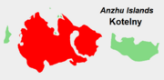
Location of Kotelny Island in the Anzhu subgroup.
-
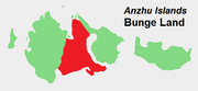
Location of Bunge Land in the Anzhu subgroup.
-
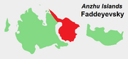
Location of the Faddeyevsky Peninsula in the Anzhu subgroup.


Nearby Islands to Explore
- Skrytyy Island (Ostrov Skrytyy) is located deep inside a bay on the northern side of Kotelny. It is about 11 kilometers long and 5.5 kilometers wide.
- Close to Bunge Land's northwest coast are two islands: Zheleznyakov Island and Matar Island. Both are about 5 kilometers long.
- Nanosnyy Island is a small, C-shaped island north of the bay between Kotelny and Bunge. It is only 4 kilometers long. However, it is important because it is the northernmost island of the New Siberian group.
- Figurina Island was once located about 30 kilometers east of Nanosnyy Island. When it was discovered in 1822, it was about 8 to 9 square kilometers in size. It had sea cliffs as high as 20 meters. Even though it appeared on maps until 1945, an expedition in the early 1940s found that Figurina Island no longer existed. It had disappeared!
How Kotelny Island Was Formed
Kotelny Island is made up of many layers of rocks and sediments. These layers formed over millions of years, from very old times (Early Paleozoic) to more recent times (Late Cenozoic). The oldest rocks are limestones and dolomites that formed in ancient seas. Over time, other rocks like sandstones and conglomerates were added.
These rock layers have been pushed and folded into complex shapes. They also have thin diabase dikes cutting through them. More recently, during the Pleistocene and Holocene periods, rivers deposited sediments in the valleys.
A thick layer of frozen ground, called permafrost, is found in these sediments. In Bunge Land and the southwest of Kotelny, younger sediments from the Early Cretaceous to Holocene periods cover the older rocks. Bunge Land is mostly covered by marine sediments from the Early Holocene.
Faddeyevsky Island's surface is also covered by sediments from the Early Cretaceous to Pleistocene. These include clays, silts, and sands, sometimes with layers of coal. The permafrost on Faddeyevsky Island is very thick, about 400 to 500 meters deep. The island's central plain has changed a lot due to thermokarst processes. This happens when the permafrost melts, creating deep cuts and mounds called baydzharakhs.
Plants and Tundra Life
Most of Faddeyevsky Island and a large part of Kotelny Island are covered by a type of tundra called rush/grass, forb, cryptogam tundra. This tundra has very low-growing plants like grasses, rushes, forbs (flowering plants), mosses, lichens, and liverworts. These plants cover most or all of the ground. The soil is usually wet and fine-grained, often with small bumps.
All of Bunge Land and the eastern part of Kotelny Island have prostrate dwarfshrub, herb tundra. This is a drier tundra with plants that are spread out or grow in patches. The main plants here are small shrubs, like Dryas species and Salix arctica, which are less than 5 centimeters tall. You can also find grasses and other herbs, along with many lichens.
The Arctic Weather of Kotelny Island
Kotelny Island has a very harsh Arctic climate. Temperatures only rise above freezing for a short time during the summer months. The winters are long and extremely cold.
| Climate data for Kotelny Island | |||||||||||||
|---|---|---|---|---|---|---|---|---|---|---|---|---|---|
| Month | Jan | Feb | Mar | Apr | May | Jun | Jul | Aug | Sep | Oct | Nov | Dec | Year |
| Record high °C (°F) | −7.2 (19.0) |
−3.3 (26.1) |
−4.8 (23.4) |
1.2 (34.2) |
6.3 (43.3) |
22.4 (72.3) |
25.1 (77.2) |
22.0 (71.6) |
13.6 (56.5) |
2.8 (37.0) |
−1.7 (28.9) |
−3.1 (26.4) |
25.1 (77.2) |
| Mean daily maximum °C (°F) | −25.6 (−14.1) |
−25.8 (−14.4) |
−23.3 (−9.9) |
−15.1 (4.8) |
−5.6 (21.9) |
2.1 (35.8) |
5.9 (42.6) |
5.2 (41.4) |
1.1 (34.0) |
−6.4 (20.5) |
−16.5 (2.3) |
−22.9 (−9.2) |
−10.6 (13.0) |
| Daily mean °C (°F) | −28.8 (−19.8) |
−29.1 (−20.4) |
−26.6 (−15.9) |
−18.5 (−1.3) |
−7.8 (18.0) |
0.2 (32.4) |
3.3 (37.9) |
2.9 (37.2) |
−0.3 (31.5) |
−8.7 (16.3) |
−19.6 (−3.3) |
−26.0 (−14.8) |
−13.2 (8.2) |
| Mean daily minimum °C (°F) | −32.1 (−25.8) |
−32.3 (−26.1) |
−30.0 (−22.0) |
−22.3 (−8.1) |
−10.5 (13.1) |
−1.6 (29.1) |
1.0 (33.8) |
0.9 (33.6) |
−2.0 (28.4) |
−11.5 (11.3) |
−23.0 (−9.4) |
−29.3 (−20.7) |
−16.1 (3.1) |
| Record low °C (°F) | −44.9 (−48.8) |
−49.9 (−57.8) |
−46.1 (−51.0) |
−46.2 (−51.2) |
−28.6 (−19.5) |
−14.9 (5.2) |
−6.0 (21.2) |
−9.2 (15.4) |
−18.6 (−1.5) |
−40.2 (−40.4) |
−40.2 (−40.4) |
−45.0 (−49.0) |
−49.9 (−57.8) |
| Average precipitation mm (inches) | 5.6 (0.22) |
5.3 (0.21) |
5.7 (0.22) |
6.9 (0.27) |
8.7 (0.34) |
17.4 (0.69) |
28.1 (1.11) |
22.8 (0.90) |
23.0 (0.91) |
17.6 (0.69) |
7.9 (0.31) |
6.7 (0.26) |
155.7 (6.13) |
| Average rainy days | 0 | 0 | 0 | 0.1 | 1 | 8 | 15 | 15 | 9 | 0.4 | 0 | 0 | 49 |
| Average snowy days | 15 | 16 | 16 | 15 | 22 | 16 | 8 | 11 | 22 | 26 | 18 | 16 | 201 |
| Average relative humidity (%) | 82 | 82 | 82 | 83 | 87 | 90 | 90 | 91 | 90 | 88 | 84 | 82 | 86 |
| Mean monthly sunshine hours | 0 | 7 | 147 | 283 | 197 | 178 | 168 | 100 | 44 | 14 | 0 | 0 | 1,138 |
| Source 1: Pogoda.ru.net | |||||||||||||
| Source 2: NOAA (sun 1961–1990) | |||||||||||||
Why Kotelny Island is Important
From 1933 to 1993, Kotelny Island was home to an important Soviet naval base. After the Soviet Union ended, the base was closed. Only a civilian Arctic research station remained on the island.
In late 2013, efforts began to reopen the base. A temporary airstrip was built to bring in supplies and people. A Russian naval group visited the New Siberian Islands in September 2013. They brought the first supplies and personnel for the base. Their main ship was the Kirov class Battlecruiser Petr Velikiy.
By September 2014, the 99th Tactic Arctic Group had permanently set up the base. They started building a military air base, a pier, and homes for troops and their families. The airfield can now receive large Ilyushin Il-76 aircraft all year round. This greatly helps with bringing supplies to the base. The base is known as the Northern Shamrock.
See also
- Baydzharakh
