
Krishna Shrine facts for kids
Quick facts for kids Krishna Shrine |
|
|---|---|

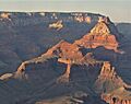
Krishna, Vishnu, & Rama prominences
(Freya Castle at left rear) |
|
| Highest point | |
| Elevation | 6,131 ft (1,869 m) |
| Prominence | 671 ft (205 m) |
| Isolation | 0.93 mi (1.50 km) |
| Parent peak | Vishnu Temple |
| Geography | |

Krishna.Shrine
Location in Arizona

Krishna.Shrine
Location in the United States
|
|
| Location | Grand Canyon National Park Coconino County, Arizona, US |
| Parent range | Kaibab Plateau (Walhalla Plateau) Colorado Plateau |
| Topo map | USGS Cape Royal |
| Geology | |
| Age of rock | Permian down to Cambrian |
| Mountain type | sedimentary rock: sandstone,siltstone, mudstone, limestone, shale |
| Type of rock | Esplanade Sandstone-(cliff-prominence-debris) Supai Group, Redwall Limestone, Muav Limestone, Bright Angel Shale |
Krishna Shrine is a tall rock formation in the eastern Grand Canyon. It stands 6,131 feet (about 1,869 meters) high. You can find it in Coconino County, in northern Arizona, USA.
This impressive landform is connected to a larger rock mass called Vishnu Temple. It is about 1.0 mile away. Krishna Shrine is also about 3.0 miles south of the Cape Royal overlook. This overlook is on the Walhalla Plateau, which is part of the southeast Kaibab Plateau. Another similar rock formation, the Rama Shrine, is located to the southeast of Vishnu Temple.
Krishna Shrine rises about 4,000 feet (about 1,219 meters) above the Colorado River. The river is about 2.0 miles south of the shrine. Both Krishna Shrine and Rama Shrine, along with Vishnu Temple, are found at the start of the Asbestos Canyon drainage.
What is Krishna Shrine Made Of?
Like Rama Shrine, Krishna Shrine is made of several layers of rock. It has a large section of the 4-unit Supai Group rocks. These sit on top of a flat area of Redwall Limestone. The very top of Krishna Shrine looks like a triangle. It also has a smaller, eroded peak.
The highest point of the shrine is a broken cliff-peak. This peak is made of the Supai Group's fourth unit. This unit is called the Esplanade Sandstone. This sandstone is famous in the Grand Canyon for forming flat, wide areas.
Exploring the Geology

(linear Dana Butte prominence attached south of Angels Gate-(photo left))
If you look closely at Krishna Shrine, you can see the different layers of red-orange Supai Group rocks. These layers are on the upper flat part of the Redwall Limestone. At Krishna Shrine, the Redwall Limestone cliffs look dark, almost blackish, instead of their usual red color.
Images for kids
-
Krishna Shrine in the center and Vishnu Temple in the upper right at sunset, seen from Grandview Point

