Lake Buchanan (Texas) facts for kids
Quick facts for kids Lake Buchanan |
|
|---|---|

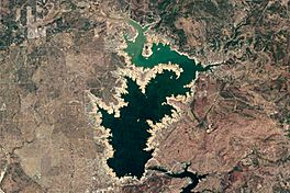
Landsat 5 image of Lake Buchanan in October 2011
|
|
| Location | Burnet / Llano counties, Texas, USA |
| Coordinates | 30°45.11′N 98°25.12′W / 30.75183°N 98.41867°W |
| Type | Hydroelectric reservoir |
| Primary inflows | Colorado River |
| Primary outflows | Colorado River |
| Managing agency | Lower Colorado River Authority |
| First flooded | 1939 |
| Surface area | 22,333 acres (34.9 sq mi; 90.4 km2) |
| Max. depth | 132 ft (40 m) |
| Water volume | 875,566 acre⋅ft (1.079995 km3) |
| Surface elevation | 1,020 ft (310 m) |
Lake Buchanan is a large lake in Texas, USA. It was made by building the Buchanan Dam. This dam helps supply water to the area. It also creates electricity using the power of water.
The Buchanan Dam is very long, over 2 miles (3.2 km). It was finished in 1939. Lake Buchanan was the first of the Texas Highland Lakes to be created. It is also the biggest, covering about 22,333 acres (90.38 km²). The lake is located in both Burnet and Llano Counties. You can find it west of the city of Burnet, Texas.
Other lakes on the Colorado River include Inks Lake, Lake LBJ, Lake Marble Falls, Lake Travis, Lake Austin, and Lady Bird Lake.
The lake is named after James P. Buchanan (1867–1937). He was a representative who helped get the money needed to build the lake and dam.
History of Lake Buchanan
Lake Buchanan was made by people when the Buchanan Dam was finished in 1938. Work on the dam started in April 1931. But it stopped for a year. Building began again in 1935. The dam was completed three years later.
The lake started filling with water in May 1937. At first, the dam and lake were called Hamilton Dam and Reservoir. But the name was changed to honor Texas State Representative James P. Buchanan. He was important because he helped get the money for the project.
When the lake filled up, the town of Bluffton had to move. It moved about 5 miles (8 km) to the west. The old town was covered by water. However, during a very dry period in 2011, the lake's water level dropped a lot. This made the remains of the old town visible again!
Fish and Wildlife in Lake Buchanan
Lake Buchanan has many types of fish. These fish were put there to make fishing fun for people. You can find fish like largemouth bass, catfish, white bass, and striped bass in the lake.
Lake Buchanan's water level is controlled. This means it usually won't flood during heavy rains. But the water level can go down a lot during dry times.
Fun Things to Do at Lake Buchanan
Many parts of the land around Lake Buchanan are owned by private people. Lots of lakeside houses and cabins are rented out often.
The Lower Colorado River Authority manages three parks on the lake. These are Cedar Point Recreation Area, Black Rock Park, and Canyon of the Eagles. County parks and private marinas also let people access the lake for boating.
Fall Creek Winery is the oldest winery in the Texas Hill Country. It is located where Fall Creek meets Lake Buchanan.
- Lake Buchanan from the Handbook of Texas Online
 | John T. Biggers |
 | Thomas Blackshear |
 | Mark Bradford |
 | Beverly Buchanan |


