
Lake Butte des Morts facts for kids
Quick facts for kids Lake Butte des Morts |
|
|---|---|

Lake Butte des Morts
|
|

Lake Butte des Morts
Location in Wisconsin
|
|
| Location | Winnebago County, Wisconsin, United States |
| Coordinates | 44°04′23″N 088°38′31″W / 44.07306°N 88.64194°W |
| Primary inflows | Fox River, Wolf River |
| Primary outflows | Fox River |
| Basin countries | United States |
| Max. length | 11.6 km (7 mi) |
| Max. width | 2.8 km (2 mi) |
| Surface area | 34.7 km2 (8,575 acres) |
| Average depth | 2.1 m (7 ft) |
| Max. depth | 2.7 m (9 ft) |
| Water volume | 65,550,085 m3 (1.7316500×10¹⁰ US gal) |
| Residence time | 6 days |
| Shore length1 | 50.6 km (31 mi) |
| Surface elevation | 226 m (741 ft) |
| Settlements | Oshkosh, Wisconsin, Butte des Morts, Wisconsin |
| 1 Shore length is not a well-defined measure. | |
Lake Butte des Morts is a shallow freshwater lake in Wisconsin. It's located in Winnebago County. This lake is part of a group of lakes called the Winnebago Pool. Other lakes in this group are Lake Winnebago, Lake Poygan, and Lake Winneconne.
The Fox River flows into the lake from the southwest. The Wolf River also feeds it from Lake Winneconne. Water then flows out through the Fox River into Lake Winnebago. It's important to know that this lake is not connected to Little Lake Butte des Morts. That lake is further north and downstream.
Contents
What's in a Name?
The name "Butte des Morts" comes from early French settlers. It means "Mound of the Dead." This name refers to an old Native American burial mound nearby. In the Menominee language, the place is called Paehkuahkīhsaeh. This means "small mound."
How Big is the Lake?
Lake Butte des Morts covers about 34.7 km2 (8,575 acres) of surface area. This makes it the second smallest of the Winnebago Pool Lakes. A lot of the lake used to be marshland. It became a lake when a dam was built on the Fox River in the 1800s.
The lake is quite shallow, with a maximum depth of only 2.7 m (9 ft). It is also narrow, being 11.6 km (7 mi) long but only 2.8 km (2 mi) wide. The water temperature changes with the seasons. It can be as cold as 0.4 °C (33 °F) in winter. In summer, it can warm up to about 26.7 °C (80 °F). The lake usually freezes over in winter.
Keeping the Water Clean
Lake Butte des Morts is known as a eutrophic lake. This means it has a lot of nutrients, which can sometimes cause problems. The Wisconsin DNR says the lake's water quality is "impaired." This is due to high levels of things like phosphorus and mercury.
Pollutants often enter the lake from farms and cities. This happens when rain washes chemicals into the water. Sometimes, large algal blooms occur. These blooms, along with high levels of E. coli, can make the water unsafe for swimming. The water often looks murky brown or green. The DNR is working on projects to help improve the lake's water quality.
Animals and Plants of the Lake
Many different fish species live in Lake Butte des Morts. You can find walleye, white bass, and largemouth bass. Other fish include carp, catfish, northern pike, and sturgeon.
The lake is also home to various wetland plants. These include American lotus and wild rice. However, some invasive species have also moved in. These include Chinese mystery snail and zebra mussel. These species can sometimes harm the native plants and animals.
Fun Things to Do at the Lake
The city of Oshkosh is located between Lake Butte des Morts and Lake Winnebago. The small community of Butte des Morts is on the lake's northern shore.
The lake was once part of the Fox–Wisconsin Waterway. This waterway allowed boats to travel between the Mississippi River and Lake Michigan. Today, a marked channel helps boats cross the lake. This channel connects the Wolf River to the Fox River, leading to Lake Winnebago.
Lake Butte des Morts is a popular spot for outdoor activities. People enjoy fishing and boating during warmer months. In winter, it becomes a great place for ice fishing.
A large bridge carries U.S. Highway 41 (US 41) and Interstate 41 (I41) across the east end of the lake. This bridge includes the Tribal Heritage Crossing, which is part of the Wiouwash State Trail. On the south shore, you can find Terrell's Island. This is a special project by the DNR to protect wetlands.

Images for kids
-
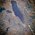
Winnebago pool, July 1996. Lake Winnebago is in the center, with Lake Butte des Morts just to the left of the center of the lake.
-
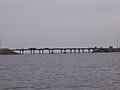
Interstate 41 bridge over Lake Butte des Morts
-
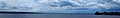
A view of Lake Butte des Morts, looking west from the Interstate 41 bridge
-
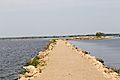
View of Lake Butte des Morts from the public trail on the Terrell's Island breakwall


