
Fox–Wisconsin Waterway facts for kids

The Fox–Wisconsin Waterway is a special water route made by connecting the Fox River and the Wisconsin River. European explorers first used this route in 1673. Marquette and Joliet were among the first. It was a main travel path between the Great Lakes and the Mississippi River. This was true until the Illinois and Michigan Canal opened in 1848. Then, railroads also started to become popular.
The waterway began at the Mississippi River in Prairie du Chien, Wisconsin. Travelers went up the Wisconsin River for about 116 miles (187 km). They reached Portage, Wisconsin. Here, they would carry their boats (a "portage") to the Upper Fox River. Later, they could use the Portage Canal. The route then followed the Fox River for about 160 miles (257 km). It went through Lake Winnebago and continued down the Lower Fox River. This part had many drops, over 170 feet (50 m) in total. The waterway ended at Green Bay.
In the mid-1800s, people improved the waterway. They built many locks, dams, and canals. This included the 2-mile (3 km) Portage Canal. All the locks were finished by 1876. By then, canals were becoming less important as railroads grew. Later, new dams stopped boats from using parts of the waterway. For example, the dam at Prairie du Sac blocked the path. The waterway was never used much for shipping. It slowly became less important. The Portage Canal closed in 1951. Most locks on the Upper Fox River were no longer used. The locks on the Lower Fox River closed in 1983. This was to stop harmful species, like the lamprey, from spreading upstream.
Today, the Fox-Wisconsin Waterway is not used for shipping between the Mississippi River and the Great Lakes. But different parts of it are popular for fun activities. People enjoy boating and fishing. There are plans to reopen the Lower Fox locks and dams.
Contents
Parts of the Waterway
The Fox-Wisconsin Waterway has four main sections:
- The Lower Wisconsin River
- "The Portage" canal and locks at Portage
- The Upper Fox River
- The Lower Fox River
The whole system is about 280 miles (450 km) long. It starts at the Mississippi River in the west. It slowly rises to Portage. At Portage, it crosses the divide between the Great Lakes and Mississippi River systems. Then, it goes down slowly along the Upper Fox River to Lake Winnebago. Finally, it drops sharply to Green Bay on Lake Michigan.
Lower Wisconsin River
The Lower Wisconsin River flows for about 116 miles (187 km). It goes from Portage to the Mississippi River. It drops about 171 feet (52 m) along the way. The river is wide and shallow. It has many sand bars and islands that often change. This made it hard for large boats to travel.
The Portage Canal
The Portage is a 2-mile (3 km) stretch in Portage, Wisconsin. It connects the Fox and Wisconsin Rivers. What makes it special is that the Wisconsin River is very large here. The Fox River is much smaller. The land between the two rivers is mostly flat and marshy. Sometimes, during high water, the Wisconsin River would even flow into the Fox River. Only about 2 miles (3 km) separate the two rivers. The Portage is about 116 miles (187 km) from the Mississippi River. It is also about 162 miles (261 km) from Green Bay.
Upper Fox River
The Upper Fox River flows about 110 miles (177 km) from Portage to Lake Winnebago. It only drops about 36 feet (11 m) along this path. This part of the river has a very gentle slope. There are two shallow lakes along the way: Buffalo Lake and Puckaway Lake. The river starts small at Portage. It grows into a small river as it gets closer to Lake Winnebago. The river channel has sand, silt, and organic material. It is shallow and gets wider and deeper as it nears Lake Winnebago.
Lower Fox River
The Lower Fox River flows from Lake Winnebago to Lake Michigan. It is about 39 miles (63 km) long. It drops a lot, about 169 feet (52 m), from Lake Winnebago to Green Bay. This section has a very steep and changing slope. There are big drops at places like Kaukauna and Appleton. The total drop here is about the same as Niagara Falls, but spread out over a longer distance. There are no major rivers joining the Lower Fox. So, the amount of water flowing stays about the same.
Early History of the Waterway
This waterway was like a highway for Native American people. Later, European explorers and fur traders used it too. It was the most used path between the Great Lakes and the Mississippi River. From Portage, people could travel in many directions. They could go north towards Lake Superior, west to the Mississippi, or northeast to Lake Michigan. Other rivers, like the Wolf River and the Rock River, were also nearby.
In the 1600s, several Native American tribes lived in this area. These included the Ho-Chunk, Menominee, Kickapoo, and Ojibwe tribes.
The first French explorers were Father Marquette and Joliet in 1673. The French controlled the area for about 100 years. This was until the French and Indian War ended. As the French settled more in the east, some Fox and Sac tribes moved to this area. They took over from the original tribes. The Fox and Sac tribes understood how important the waterway was. They set up toll stations where people had to carry their boats. The French did not like this because it hurt their trade. This led to a series of wars called the Fox Wars.
French traders were very important along the waterway. They built forts or settlements at places like La Baye (Green Bay), Portage, and Prairie du Chien. You can still see their influence in many place names today. Many cities along the waterway, like Prairie du Chien and Green Bay, are among the oldest in Wisconsin.
The British took control after the American Revolutionary War. Then, after the War of 1812, the American government was in charge. The Fox tribe was finally forced out of the waterway area in 1832. This happened during the Black Hawk War.
Changes to the Waterway
When steamships arrived and canals in the east, like the Erie Canal, became successful, people wanted to improve the Fox-Wisconsin Waterway. They hoped it would connect the Erie Canal to the Mississippi River. Shipping goods down the Mississippi River from the Midwest was expensive. This slowed down economic growth. People thought a direct waterway would help the local economy.
The first improvements started at Portage in 1829. A company tried to build the Portage Canal. But they ran out of money. The U.S. Army Corps of Engineers (Corps) looked at the project. They realized it needed work along both rivers, not just the canal. In 1846, Congress gave land to help fund the project. Several private companies tried to build the waterway. Finally, in 1872, the Corps took over the project.
- Postcards from 1867-1870 for various towns along the waterway. Note the prominence of steamboats.
-
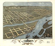
Prairie du Chien
-
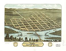
Sauk City
-
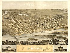
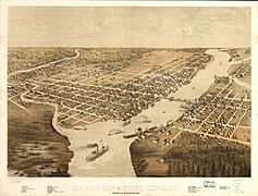
Portage
-
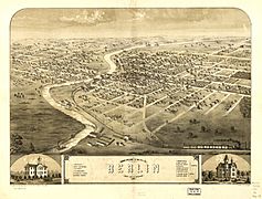
Berlin
-
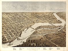
Appleton
-
Green Bay


Improvements on the Lower Wisconsin River
At first, there were no big plans for the Lower Wisconsin River. They only planned to clear out logs and sand. But this was not enough. In 1868, the Corps tried building wing dams and dredging. They wanted to make a 6-foot (1.8 m) deep channel. By 1880, they had built many dams. But these dams also did not work well. Steamboats were still afraid to use the river. In 1887, the Corps stopped trying to improve this section. This basically closed the Lower Wisconsin to commercial boats.
So, very few commercial boats ever used this part of the waterway. In 1914, the Prairie du Sac hydroelectric plant was built. This created Lake Wisconsin. This dam is the lowest of many dams on the Upper Wisconsin River.
Improvements at The Portage
Construction on the Portage Canal started in 1849 and finished in 1851. In 1856, the first steamship from the Mississippi, called the Aquila, traveled through Portage to Green Bay. This meant the waterway was open! The lock and canal were improved many times. A new concrete structure was built in 1928. There was a guard lock on the Wisconsin River side and a lifting lock to lower boats to the Fox River. Each lock was 140 feet (43 m) long and 35 feet (11 m) wide.
Over time, traffic dropped off. Only pleasure boats used it. By 1900, there was almost no boat traffic to the east. The Wisconsin River side of the canal had problems with floods and sand. The canal needed to be dredged often. In 1959, the Corps closed and took apart most of the Fort Winnebago Lock. In 1961, the state of Wisconsin took over the canal.

Improvements on the Upper Fox River
At first, only dredging was done on the Upper Fox River. Later, several dams and locks were added. In the end, seven stone locks were built. Each lock could lift boats about 5 feet (1.6 m). They were about 140 feet (43 m) long and 35 feet (11 m) wide.
Dredging was very important because the Upper Fox River had low water flow. By 1899, dredging had created a 6-foot (1.8 m) deep channel to Berlin. It was 4 feet (1.2 m) deep between Berlin and Montello. It was 3 feet (0.9 m) deep to Portage. But the river quickly filled with silt when dredging stopped.
Initially, there was enough boat traffic. Steamships, tugs, and barges carried lumber, coal, and grain. In 1867, the Corps said that the area between Berlin and Portage depended on the river for transportation. But railroads soon changed this. Travel and trade on the Lower Fox River dropped by the 1880s. Most goods could be moved more easily by train. Except for a short time during World War I, most traffic by the early 1900s was pleasure boats.
By 1922, dredging stopped. The Corps suggested closing the Upper Fox River. But Congress did not act on it. The Corps finally closed the Upper Fox to navigation between Portage and Eureka in 1951. They gave it to the state as a recreational waterway. Dams were changed to keep water levels good for wildlife.
Improvements on the Lower Fox River
Along the Lower Fox River, people worked to build dams, locks, and canals. This was to bypass the many waterfalls. The biggest challenge was building locks and dams to lift boats to Lake Winnebago. Dams started at De Pere and continued to Lake Winnebago at Menasha. The most locks were built between Kaukauna and the Cedars. This is where the biggest waterfalls were.

Construction began in 1830. People were encouraged to move to the area to work. Irish settlers moved to Wrightstown. Dutch settlers founded Little Chute and Holland. By 1850, the company building the waterway failed. The State of Wisconsin took over. The Lower Fox locks and dams were finished by 1856.
Over time, the dams and locks were improved. In the end, 17 locks were built. Each lock could lift boats about 10 feet (3 m). They were about 140 to 150 feet (43 to 46 m) long and 35 feet (11 m) wide. Dredging was needed to keep a 6-foot (1.8 m) deep channel.
Travel and trade on the Lower Fox River were the most successful. Boats carried people, mail, and many products. Local industries along the river used the power from the waterfalls. This created a steady market for goods. Regular steamboat travel continued until the 1900s.
However, railroads still became the main way to transport goods. Boat traffic dropped sharply. In 1983, the entire system was put into "caretaker" status. The government stopped all maintenance. The state of Wisconsin operated the locks until 1987. After that, canals were drained, and lock gates were sealed. The lock at Rapide Croche was sealed to stop sea lampreys from reaching Lake Winnebago. Recently, the system has been repaired. There are plans to open it for boats again.
Why the Waterway Didn't Fully Succeed
In the end, the Fox–Wisconsin Waterway did not become a major extension of the Erie Canal. There were two main problems. First, they could not fully control the sand bars in the Lower Wisconsin River. Second, the Upper Fox River had very low water flow. Also, the waterway could not compete with canals near Chicago or with the reliable railroads.
The Waterway Today
Each part of the waterway is changing.
Lower Wisconsin River Today
Downstream of the Prairie du Sac Dam, the Wisconsin River flows freely for 93 miles (147 km) to the Mississippi. This is one of the longest free-flowing stretches in the eastern United States. It is a popular place for canoeing and small boats. Most of this area is part of the Lower Wisconsin State Riverway. This project aims to protect the river's beauty and natural character. It also provides a public recreation area.
Upstream of the dam, Lake Wisconsin is popular for boating and fishing. It is unlikely that commercial boat traffic will return to this part of the river soon.
The Portage Today
Today, people are working to restore the Portage Locks as a historical site. The Canal is now on the National and State Register of Historic Places. This was thanks to the Portage Canal Society. In 1983, the downtown area was restored. In 1987, the south bank of the canal became part of the National Ice Age Trail.
It is unlikely that commercial boat traffic will return to this part of the waterway soon.
Upper Fox River Today
The Wisconsin Department of Natural Resources (DNR) wants to make the Upper Fox River more natural. Most of the locks have been removed or left unused. The dam at White River was removed in 2004. Plans are to remove all dams except those at Princeton and Montello. The dam at Eureka has been changed into a fishway. This allows fish to swim upstream to lay eggs. The locks there still work.

It is unlikely that commercial boat traffic will return to this part of the waterway soon.
Lower Fox River Today
All the locks along the Lower Fox River are on the National and State Register of Historic Places. Since 1983, people have tried to save the locks from closing forever. In 2001, the Army Corps of Engineers gave ownership of the 17 locks to the State of Wisconsin. The Fox River Navigational System Authority was created. Funds from the Army Corps, Wisconsin, and private donations have helped repair and reopen the locks.
Most of the locks on the Lower Fox River are now working again. But some remain closed for navigation. The Menasha lock is closed to stop the round goby, a harmful species, from entering Lake Winnebago. An electric fish barrier is planned to help reopen this lock. The Kaukauna locks are also closed. This is because the Kaukauna Bridge needs to be fixed before boats can use them.
The Rapid Croche Lock will stay sealed. It acts as a barrier to stop sea lampreys. A boat lift and transfer station have been suggested. This would allow boats to travel through the entire Lower Fox River system. This station would also clean boats to prevent the spread of harmful species.

It is unlikely that commercial freight traffic will return to this part of the river. However, recreational boats and tour boats use the locks regularly.
Waterway Features
Here is a list of features along the waterway, from Lake Michigan to the Mississippi River (east to west):
| Location | Feature | Elevation
(lower pool) |
Elevation
(upper pool) |
River distance
from Green Bay |
River distance
from Prairie du Chien |
Comment |
|---|---|---|---|---|---|---|
| Green Bay | Green Bay | 578 ft (176 m) | 578 ft (176 m) | 0 mi (0 km) | 280 mi (451 km) | |
| De Pere | Lock | 578 ft (176 m) | 588 ft (179 m) | 7 mi (11 km) | 273 mi (439 km) | Operating |
| Wrightstown | Little Kaukauna Lock & Dam | 588 ft (179 m) | 592 ft (180 m) | 13 mi (21 km) | 267 mi (430 km) | Operating |
| Wrightstown | Rapide Croche Lock & dam | 592 ft (180 m) | 603 ft (184 m) | 20 mi (32 km) | 260 mi (418 km) | Permanently closed. Boat lift planned for opening 2017. |
| Kaukauna | Lock 5 | 603 ft (184 m) | 612 ft (187 m) | 24 mi (39 km) | 256 mi (412 km) | Upgraded |
| Kaukauna | Lock 4 | 612 ft (187 m) | 622 ft (190 m) | 24 mi (39 km) | 256 mi (412 km) | Upgraded |
| Kaukauna | Lock 3 | 622 ft (190 m) | 632 ft (193 m) | 24 mi (39 km) | 256 mi (412 km) | Upgraded |
| Kaukauna | Lock 2 | 632 ft (193 m) | 642 ft (196 m) | 24 mi (39 km) | 256 mi (412 km) | Upgraded |
| Kaukauna | Lock 1 | 642 ft (196 m) | 652 ft (199 m) | 24 mi (39 km) | 256 mi (412 km) | Has guard lock, being upgraded |
| Combined Locks | Lower Lock | 652 ft (199 m) | 662 ft (202 m) | 26 mi (42 km) | 254 mi (409 km) | Upgraded |
| Combined Locks | Upper Lock | 662 ft (202 m) | 672 ft (205 m) | 26 mi (42 km) | 254 mi (409 km) | Upgraded |
| Little Chute | Lock & Dam | 672 ft (205 m) | 685 ft (209 m) | 27 mi (43 km) | 253 mi (407 km) | Has guard lock, being upgraded with completion in 2017. |
| Kimberly | Cedar Lock & Dam | 685 ft (209 m) | 695 ft (212 m) | 28 mi (45 km) | 252 mi (406 km) | Operating |
| Appleton | Lock 4 | 695 ft (212 m) | 705 ft (215 m) | 31 mi (50 km) | 249 mi (401 km) | Operating |
| Appleton | Lock 3 | 705 ft (215 m) | 715 ft (218 m) | 32 mi (51 km) | 248 mi (399 km) | Operating |
| Appleton | Lock 2 | 715 ft (218 m) | 725 ft (221 m) | 32 mi (51 km) | 248 mi (399 km) | Operating |
| Appleton | Lock 1 | 725 ft (221 m) | 735 ft (224 m) | 32 mi (51 km) | 248 mi (399 km) | Operating |
| Appleton | Little Lake Butte des Morts | 735 ft (224 m) | 735 ft (224 m) | 37 mi (60 km) | 243 mi (391 km) | Lake |
| Menasha | Lock | 735 ft (224 m) | 746 ft (227 m) | 37 mi (60 km) | 243 mi (391 km) | Operating |
| Neenah | Lake Winnebago | 746 ft (227 m) | 746 ft (227 m) | 39 mi (63 km) | 241 mi (388 km) | Lake |
| Oshkosh | Big Lake Butte des Morts | 746 ft (227 m) | 746 ft (227 m) | 65 mi (105 km) | 215 mi (346 km) | Lake |
| Butte Des Morts | Wolf River | 746 ft (227 m) | 746 ft (227 m) | 66 mi (106 km) | 214 mi (344 km) | Major tributary |
| Eureka | Fishway and Lock | 746 ft (227 m) | 750 ft (229 m) | 80 mi (129 km) | 200 mi (322 km) | Operating |
| Berlin | Abandoned Dam & Lock | 750 ft (229 m) | 754 ft (230 m) | 90 mi (145 km) | 190 mi (306 km) | Slated for removal |
| White River | Open River | 754 ft (230 m) | 754 ft (230 m) | 96 mi (154 km) | 184 mi (296 km) | Removed |
| Princeton | Dam and Abandoned Lock | 754 ft (230 m) | 757 ft (231 m) | 98 mi (158 km) | 182 mi (293 km) | Crest boards |
| Marquette | Puckaway Lake | 763 ft (233 m) | 763 ft (233 m) | 122 mi (196 km) | 158 mi (254 km) | Lake |
| Grand River | Abandoned Dam & Lock | 763 ft (233 m) | 764 ft (233 m) | 131 mi (211 km) | 149 mi (240 km) | Slated for removal |
| Montello | Dam and Abandoned Lock | 764 ft (233 m) | 764 ft (233 m) | 131 mi (211 km) | 149 mi (240 km) | |
| Endeavor | Buffalo Lake | 769 ft (234 m) | 769 ft (234 m) | 142 mi (229 km) | 138 mi (222 km) | Lake |
| Governor's Bend Park | Abandoned Dam & Lock | 769 ft (234 m) | 774 ft (236 m) | 147 mi (237 km) | 133 mi (214 km) | Slated for removal |
| Portage | Portage Canal | 780.0 ft (238 m) | 780 ft (238 m) | 162 mi (261 km) | 118 mi (190 km) | Closed |
| Portage | Lock at Wis River | 780 ft (238 m) | 782 ft (238 m) | 165 mi (266 km) | 115 mi (185 km) | Closed |
| Prairie du Sac | Lake Wisconsin | 774 ft (236 m) | 774 ft (236 m) | 176 mi (283 km) | 104 mi (167 km) | |
| Merrimac | Ferry | 774 ft (236 m) | 774 ft (236 m) | 180 mi (290 km) | 101 mi (163 km) | |
| Prairie du Sac | Dam | 735 ft (224 m) | 774 ft (236 m) | 188 mi (303 km) | 92 mi (148 km) | Locks unusable |
| Prairie du Chien | Mississippi River | 611 ft (186 m) | 611 ft (186 m) | 280 mi (451 km) | 0 mi (0 km) | Mississippi River Mile 631 |
