Lake Tight facts for kids
Quick facts for kids Lake Tight |
|
|---|---|

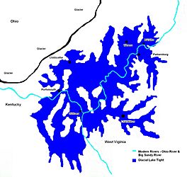
How big Glacial Lake Tight was about 500,000 years ago.
|
|
| Location | Ohio & West Virginia |
| Coordinates | 38°48′N 82°13′W / 38.8°N 82.21°W |
| Lake type | former lake |
| Etymology | William G. Tight |
| Primary inflows | Laurentide Ice Sheet |
| Primary outflows | Ohio River |
| Basin countries | United States |
| First flooded | 2,000,000 years before present |
| Max. length | ca. 85 mi (137 km) |
| Max. width | ca. 90 mi (140 km) |
| Surface area | 9,920 sq mi (25,700 km2) |
| Average depth | 340 ft (100 m) |
| Max. depth | 400 ft (120 m) |
| Residence time | 170,000 years in existence |
| Surface elevation | ca. 1,160 ft (354 m) |
Lake Tight was a huge glacial lake that existed during the Ice Age. It was named after a geologist called William G. Tight. This ancient lake covered parts of what we now know as Ohio, Kentucky, and West Virginia. It formed very early in the Pleistocene epoch, which was a long time ago, even before 700,000 years ago.
How Lake Tight Formed
Lake Tight started forming almost 2 million years ago. This was when the Ice Age began to make the Earth much colder. Huge sheets of ice, called glaciers, started to move slowly south from what is now Canada. As these glaciers moved, they changed the land a lot. They even blocked or destroyed many natural features, including a very old river called the Teays River.
The Teays River had been flowing for millions of years. It started in the Appalachian Mountains (in what is now North Carolina). From there, it flowed north through areas that are now West Virginia, Kentucky, Ohio, Indiana, and Illinois. Finally, it emptied into the Gulf of Mexico, which at that time reached further north into Illinois.
But the moving glaciers of the Ice Age soon blocked the Teays River. This acted like a giant natural dam. When the river was blocked, its water had nowhere to go, so it began to fill up the valley. This is how Lake Tight was created, near the area where Chillicothe, Ohio is today.
Size and Impact of Lake Tight
In terms of geology, Lake Tight did not last forever; its "life span" was quite short. Scientists believe it formed in the early or middle part of the Pleistocene epoch. The types of clay found in the area show that the lake is older than 700,000 years.
At its biggest, Lake Tight was about 900 feet (270 m) deep. It covered an area of about 7,000 square miles (18,000 km2). To give you an idea, that's almost two-thirds the size of Lake Erie!
When Lake Tight finally overflowed, it created new drainage channels. These channels became new rivers that flowed south. This was the opposite direction of the old Teays River.
New Discoveries About Lake Tight
In 2014, a new study used special computer mapping tools called Geographic Information System (GIS) Technologies. This study looked at how big Lake Tight really was. Scientists used detailed elevation maps from the USGS (United States Geological Survey). They combined these maps with other geological data from Ohio.
This new research showed that Lake Tight was about 40% larger than people had thought before! It covered an area of about 25,740 square kilometres (9,940 sq mi). This means that at its largest, Lake Tight was actually as big as Lake Erie is today.
Evidence for this new, larger boundary comes from special deposits called the Minford Silt Member of the Teays Formation. These silts are found in many places, especially in the smaller valleys that fed into the lake. Their spread strongly supports the idea that Lake Tight was much bigger than we once thought.
 | Leon Lynch |
 | Milton P. Webster |
 | Ferdinand Smith |


