Langlade, Wisconsin facts for kids
Quick facts for kids
Langlade, Wisconsin
|
|
|---|---|

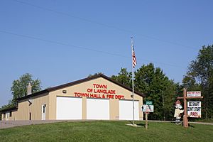
Town of Langlade Town Hall and Fire Station, located in Lily
|
|

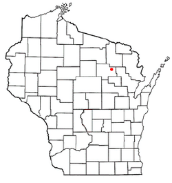
Location of Langlade, Wisconsin
|
|
| Country | |
| State | |
| County | Langlade |
| Area | |
| • Total | 72.5 sq mi (187.8 km2) |
| • Land | 71.5 sq mi (185.3 km2) |
| • Water | 1.0 sq mi (2.5 km2) |
| Elevation | 1,421 ft (433 m) |
| Population
(2010)
|
|
| • Total | 473 |
| • Density | 7/sq mi (2.6/km2) |
| Time zone | UTC-6 (Central (CST)) |
| • Summer (DST) | UTC-5 (CDT) |
| ZIP Code | |
| Area code(s) | 715 & 534 |
| FIPS code | 55-42425 |
| GNIS feature ID | 1583526 |
Langlade is a small town located in Langlade County, Wisconsin, in the United States. In 2010, about 473 people lived there.
Several smaller communities are part of Langlade town. These include Choate, Freeman, Lily, and Pickerel.
The town has its own fire department, called the Town of Langlade Fire Department. For medical emergencies, ambulance services are provided by the Pickerel Rescue Squad.
Contents
Geography of Langlade
Langlade is in the eastern part of Langlade County. To its north, it shares a border with Forest County.
Rivers and Waterways
The Wolf River flows through the town from northwest to southeast. This river is part of a larger water system that leads to Green Bay and then to Lake Michigan. The Lily River joins the Wolf River in the town.
Key Communities and Roads
The community of Lily is near the center of Langlade town. It is located on the east side of the Wolf River. Two important state highways, Highway 52 and Highway 55, meet in Lily.
- Highway 52 goes northeast about 17 miles (27 km) to Wabeno. It also goes southwest about 21 miles (34 km) to Antigo, which is the main city of Langlade County.
- Highway 55 goes north about 24 miles (39 km) to Crandon. It also goes southeast about 45 miles (72 km) to Shawano.
Pickerel is another community in Langlade town, located in the northwest corner along Highway 55. It has its own post office. Choate and Freeman are communities in the northern part of the town, found along Highway 52.
Land and Water Area
According to the United States Census Bureau, the total area of Langlade town is about 72.5 square miles (187.8 square kilometers). Most of this area, about 71.5 square miles (185.3 square kilometers), is land. The remaining 1.0 square mile (2.5 square kilometers), or 1.35%, is water.
Population and People
The census of 2000 recorded that 472 people lived in Langlade. There were 208 households and 147 families. The population density was about 6.6 people per square mile (2.5 people per square kilometer). There were 375 housing units in the town.
Who Lives in Langlade?
Most people in Langlade are White, making up about 98.73% of the population. A small number of residents are Native American (0.42%). About 0.85% of the population identified as being from two or more races.
Households and Families
Out of 208 households:
- About 20.2% had children under 18 living with them.
- About 63.5% were married couples living together.
- About 3.8% were female householders without a husband present.
- About 29.3% were non-family households.
Around 23.1% of all households were made up of individuals living alone. About 11.5% of households had someone aged 65 or older living alone. The average household had 2.27 people, and the average family had 2.66 people.
Age Groups
The population in Langlade was spread out by age:
- 18.4% were under 18 years old.
- 3.4% were between 18 and 24 years old.
- 25.4% were between 25 and 44 years old.
- 29.9% were between 45 and 64 years old.
- 22.9% were 65 years or older.
The average age of people in Langlade was 47 years. For every 100 females, there were about 110.7 males.
See also
 In Spanish: Langlade (Wisconsin) para niños
 | Jewel Prestage |
 | Ella Baker |
 | Fannie Lou Hamer |

