Lapel, Indiana facts for kids
Quick facts for kids
Lapel, Indiana
|
|
|---|---|

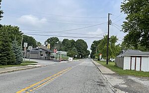
Lapel in 2022
|
|

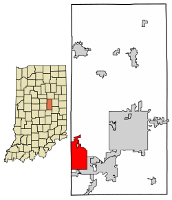
Location in Madison County, Indiana
|
|
| Country | United States |
| State | Indiana |
| County | Madison |
| Townships | Stony Creek, Green |
| Area | |
| • Total | 10.37 sq mi (26.85 km2) |
| • Land | 10.37 sq mi (26.85 km2) |
| • Water | 0.00 sq mi (0.00 km2) |
| Elevation | 856 ft (261 m) |
| Population
(2020)
|
|
| • Total | 2,325 |
| • Density | 224.23/sq mi (86.58/km2) |
| Time zone | UTC-5 (Eastern (EST)) |
| • Summer (DST) | UTC-4 (EDT) |
| ZIP code |
46051
|
| Area code(s) | 765 |
| FIPS code | 18-42228 |
| GNIS feature ID | 2396708 |
Lapel is a town located in Madison County, Indiana, United States. It's found in two different areas called townships: Stony Creek and Green. Lapel is also considered part of the larger Indianapolis–Carmel–Anderson metropolitan area. In 2020, the town had a population of 2,325 people. This was an increase from 2,068 people counted in 2010.
Contents
History of Lapel
Lapel was officially planned out and started in 1876. Two people, David Conrad and Samuel Busby, were responsible for laying out the town. They did this when a new railroad line was built through the area. The town got its unique name, "Lapel," because the way the railroad was built made the town's shape look like the lapel of a man's coat.
Geography of Lapel
Lapel is located in the southwestern part of Madison County. It shares borders with other towns and areas nearby. To the south, it's next to Ingalls, and to the southeast, you'll find Pendleton. North of Lapel is an area called Fishersburg, which is not an incorporated town.
Roads and Transportation
Several important roads pass through or near Lapel. Indiana State Road 13 goes right through the middle of town. This road is also known as Pendleton Avenue. If you go south on State Road 13, it's about 9 miles to Fortville. If you head north, it's about 15 miles to Elwood.
State Road 32 runs along the northern edge of Lapel. Traveling east-northeast on State Road 32 will take you about 9 miles to Anderson, which is the main city and county seat. Going west-southwest the same distance will lead you to Noblesville. Another road, State Road 132, goes southeast from Lapel about 7 miles to the center of Pendleton.
Waterways Near Lapel
According to the U.S. Census Bureau, Lapel covers a total area of about 10.37 square miles, and all of it is land. A creek called Stony Creek flows just north of the town's boundaries. This creek eventually flows southwest into the White River in Noblesville. Another waterway, Mud Creek, starts as several small streams in the undeveloped southern part of Lapel. It flows southwest and eventually joins Fall Creek in Lawrence.
Population Information
| Historical population | |||
|---|---|---|---|
| Census | Pop. | %± | |
| 1900 | 869 | — | |
| 1910 | 1,045 | 20.3% | |
| 1920 | 1,079 | 3.3% | |
| 1930 | 1,140 | 5.7% | |
| 1940 | 1,146 | 0.5% | |
| 1950 | 1,389 | 21.2% | |
| 1960 | 1,772 | 27.6% | |
| 1970 | 1,796 | 1.4% | |
| 1980 | 1,881 | 4.7% | |
| 1990 | 1,742 | −7.4% | |
| 2000 | 1,855 | 6.5% | |
| 2010 | 2,068 | 11.5% | |
| 2020 | 2,325 | 12.4% | |
| U.S. Decennial Census | |||
The population of Lapel has grown over the years. The table above shows how many people lived in the town during different census years. For example, in 1900, there were 869 residents, and by 2020, the population had grown to 2,325.
Education in Lapel
Lapel has schools for students of all ages. There is an elementary school, a junior high school, and a high school. A new building for the high school was completed in December 2007. The schools in Lapel are part of the Frankton-Lapel School Corporation, which serves the central part of Madison County.
Lapel also has a public library. It is a branch of the Anderson Public Library, providing books and resources for everyone in the community.
See also
 In Spanish: Lapel (Indiana) para niños
 | Audre Lorde |
 | John Berry Meachum |
 | Ferdinand Lee Barnett |

