Laurel, Delaware facts for kids
Quick facts for kids
Laurel, Delaware
|
|
|---|---|

Spring Garden
|
|
| Etymology: Laurel bushes that grew alongside Broad Creek | |

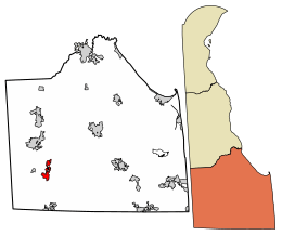
Location of Laurel in Sussex County, Delaware.
|
|
| Country | |
| State | |
| County | |
| Area | |
| • Total | 2.86 sq mi (7.40 km2) |
| • Land | 2.77 sq mi (7.16 km2) |
| • Water | 0.09 sq mi (0.24 km2) |
| Elevation | 26 ft (8 m) |
| Population
(2020)
|
|
| • Total | 3,865 |
| • Density | 1,397.32/sq mi (539.47/km2) |
| Time zone | UTC−5 (Eastern (EST)) |
| • Summer (DST) | UTC−4 (EDT) |
| ZIP code |
19956
|
| Area code | 302 |
| FIPS code | 10-41310 |
| GNIS feature ID | 214203 |
Laurel is a town in Sussex County, Delaware, United States. It is part of the Salisbury, Maryland-Delaware Metropolitan Statistical Area. In 2020, about 3,865 people lived there. Laurel was once home to a baseball team called the Laurel Blue Hens.
Contents
History of Laurel
The area where Laurel is now located was once a settlement for the Nanticoke Indian tribe. This settlement was known as Broad Creek Town. It was created in 1711 when the government set aside land for the Nanticoke Indians. Most of the Nanticoke people moved away within 50 years.
The current town of Laurel was started in the 1790s. It was named after the many laurel bushes that grew along the Broad Creek.
Town Merger and Census Records
On March 29, 1929, Laurel joined with the nearby town of North Laurel. North Laurel was mostly the area north of Broad Creek. This merger was not correctly reported to the United States Census Bureau. Because of this, North Laurel's population was not counted with Laurel's in the 1930 United States Census. The Census Bureau later confirmed that the correct population for Laurel in 1930 was 2,542 people.
West Laurel Community
West Laurel is one of Delaware's oldest communities for free Black people. Its history goes back to the 1790s. In the 1870s, Captain Theodore Marsh moved to West Laurel. He bought land, divided it into smaller plots, and sold them to his shipmates. The graveyard for the New Zion United Methodist Church in West Laurel is where Captain Marsh and his shipmates are buried. This church has been around since the early 1800s.
Geography of Laurel
Laurel is located in southwestern Delaware. It is part of the Atlantic Coastal Plain. The town's exact location is at 38.5565041 degrees North latitude and -75.5713141 degrees West longitude.
The United States Census Bureau says that Laurel covers a total area of about 2.86 square miles (7.40 square kilometers). Most of this area is land, about 2.77 square miles (7.16 square kilometers). A small part, about 0.09 square miles (0.24 square kilometers), is water.
Population and People
| Historical population | |||
|---|---|---|---|
| Census | Pop. | %± | |
| 1860 | 970 | — | |
| 1870 | 1,080 | 11.3% | |
| 1880 | 1,022 | −5.4% | |
| 1890 | 2,388 | 133.7% | |
| 1900 | 1,825 | −23.6% | |
| 1910 | 2,166 | 18.7% | |
| 1920 | 2,253 | 4.0% | |
| 1930 | 2,542 | 12.8% | |
| 1940 | 2,884 | 13.5% | |
| 1950 | 2,700 | −6.4% | |
| 1960 | 2,709 | 0.3% | |
| 1970 | 2,408 | −11.1% | |
| 1980 | 3,052 | 26.7% | |
| 1990 | 3,226 | 5.7% | |
| 2000 | 3,668 | 13.7% | |
| 2010 | 3,708 | 1.1% | |
| 2020 | 3,865 | 4.2% | |
| U.S. Decennial Census | |||
In 2000, there were 3,668 people living in Laurel. These people lived in 1,389 households, with 957 families. The population density was about 2,216 people per square mile.
Many households in Laurel have children. About 37.9% of households had children under 18 living with them. The average household had 2.64 people, and the average family had 3.19 people.
The age of people in Laurel varies. About 33.2% of the population was under 18 years old. About 12.9% of the population was 65 years or older. The average age in the town was 30 years old.
Arts and Culture in Laurel
Laurel has several places that are important to its history. These sites are listed on the National Register of Historic Places.
Historic Sites
- Chipman Potato House
- Chipman's Mill
- Collins Potato House
- Hearn Potato House
- E. L. Hitch Potato House
- Laurel Historic District
- Moore Potato House
- Old Christ Church
- Phillips Potato House
- Ralph Potato House
- Rider Potato House
- Ross Point School
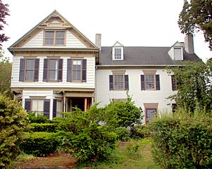
- Spring Garden
- Stanley Potato House
- Wright Potato House
Laurel Public Library
The Laurel Public Library first opened in 1909. A new and modern library building was opened in 2006.
Sports in Laurel
Laurel has a strong sports history. In 2011, the District 3 All-Stars from Laurel won the senior Little League Softball World Series. This was a big achievement for the town.
The Laurel Blue Hens were a minor league baseball team. They played in the Eastern Shore League in 1922 and 1923. Their home games were at League Park.
Education in Laurel
Students in Laurel attend schools within the Laurel School District. The local high school for students in the area is Laurel High School.
Media in Laurel
Laurel has its own local media outlets. These include:
- Laurel Star, a weekly newspaper for the community.
- Leader and State Register, another weekly local newspaper.
- WBOC-TV (Channel 16), which is a CBS television station. Its broadcast tower is located in Laurel.
- FOX 21 (Channel 21), which is a FOX television station. Its broadcast tower is also in Laurel.
- WKDB (95.3FM), a local radio station known as "Studio 95.3".
Transportation in Laurel
Roads and Highways
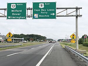
Most people travel to and from Laurel by road. U.S. Route 13, also called Sussex Highway, is the main road. It goes north to Dover and south to Salisbury.
U.S. Route 9 also serves Laurel. It starts at US 13 and heads northeast towards Georgetown. This road is known as County Seat Highway. Delaware Route 24 is another important road. It runs east to west through the center of Laurel.
Public Transportation
DART First State offers bus service in Laurel. The Route 212 bus connects Laurel with nearby towns like Delmar and Georgetown.
Railroad
The Delmarva Central Railroad has a train line, the Delmarva Subdivision, that runs north and south through Laurel.
Famous People from Laurel
Many notable people have connections to Laurel. These include:
- Richard H. Ellis, a General in the United States Air Force.
- Mark Briscoe, a professional wrestler.
- Jay Briscoe, also a professional wrestler.
- Bert Carvel, who was a former Governor of Delaware.
- John Collins, a former governor of Delaware (from 1821 to 1825).
- William B. Cooper, another former governor of Delaware.
- Timothy Dukes, a Republican member of the Delaware House of Representatives.
- Carlton Elliott, a former player in the NFL.
- Alex Ellis, a current player in the NFL.
- Dallas Marvil, an All-American football player in 1931.
- Joshua H. Marvil, a former governor of Delaware.
- Nathaniel Mitchell, a former governor of Delaware (from 1805 to 1808) and a member of the Continental Congress.
- Ron Waller, a former player and coach in the NFL.
See also
 In Spanish: Laurel (Delaware) para niños
 | Leon Lynch |
 | Milton P. Webster |
 | Ferdinand Smith |


