Laverstock facts for kids
Quick facts for kids Laverstock |
|
|---|---|
 Riverside Road, Laverstock |
|
| Population | 10,277 (2021 Census) |
| OS grid reference | SU159309 |
| Civil parish |
|
| Unitary authority |
|
| Ceremonial county | |
| Region | |
| Country | England |
| Sovereign state | United Kingdom |
| Post town | Salisbury |
| Postcode district | SP1, SP4 |
| Dialling code | 01722 |
| Police | Wiltshire |
| Fire | Wiltshire |
| Ambulance | Great Western |
| EU Parliament | South West England |
| UK Parliament |
|
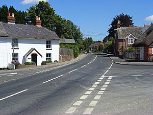
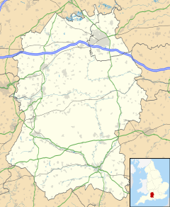
Laverstock is a village and civil parish located just outside Salisbury in Wiltshire, England. The parish has a unique shape, like the number 7. It includes the small village of Ford, part of the old area called Milford, the land near the ancient site of Old Sarum, and a section of the Hampton Park area.
Laverstock, the main village, sits on the east side of the River Bourne. It's about 1 mile (1.6 km) east of Salisbury city centre. It's also about 33 miles (53 km) south of Swindon and 77 miles (124 km) west-southwest of London.
Contents
Exploring Laverstock's Past
Scientists have found signs of very old settlements in Laverstock. On Burrough's Hill, they discovered flint mines and ancient burial mounds called barrows. This shows people lived here as far back as the Stone Age. There's also proof of settlements during the Iron and Bronze Ages. A Roman cemetery and settlement were found on Cocky's Hill.
Laverstock is even mentioned in the Domesday Book, a famous survey from 1086. This book shows that Wilton Abbey owned most of the land, with some parts belonging to the king's officers.
Old Bridges and Big Houses
The Milford Mill Bridge, which connects Laverstock to Salisbury over the River Bourne, is very old. It was built in the 1300s and is now a Grade I listed building, meaning it's very important historically.
Another bridge, St Thomas's Bridge, is named after Thomas Becket. He walked an ancient path through this area. This bridge was built around 1700 and made wider in 1900.
Laverstock used to have several large, grand houses. These included Laverstock Hall, Laverstock House, Laverstock Hill, and Burroughs Hill. Laverstock House was a well-known private hospital for mental health from the 1700s to the 1900s. It closed in 1955. Today, all these large houses have been taken down to make way for new homes.
Laverstock Pottery: A Special Craft
In the 1200s and 1300s, Laverstock was famous for its pottery. Potters here made special tall jugs called baluster jugs. These jugs had colorful glazes and were sold all over southern England. They were even supplied to the nearby Clarendon Palace.
What made Laverstock pottery unique was its use of tin in the glaze. This special ingredient helps experts today tell Laverstock pottery apart from other pottery. Besides fancy jugs, potters also made everyday items like money boxes, cooking pots, tiles, and chimney pots. The workshops and kilns (ovens for firing pottery) were located near where Potters Way and Duck Lane are today.
Laverstock's Location and Areas
Laverstock parish includes the main village of Laverstock, the hamlet of Ford, and part of Milford. It also has several newer housing areas. Even though it's part of Salisbury's urban area, Laverstock has its own local government, called a parish council.
Milford: A Busy Suburb
Milford was once an ancient area, first mentioned in 1275 as belonging to the Bishop of Salisbury.
Over time, parts of Milford became part of Salisbury city. Today, Milford is a suburb in eastern Salisbury. It's located along the A36 road, which locals call Southampton Road. Milford is home to a large retail park with many shops. The area is still split between Salisbury and Laverstock parishes. The eastern half is in Laverstock parish, while the western half is in Salisbury. Milford is bordered by the A36 road, Laverstock, and the River Bourne.
Laverstock Village: Home and Schools
Laverstock is a suburban village on the eastern edge of Salisbury. It's about 1.2 miles (2 km) east-northeast of the city centre. The village has a few local businesses, like a fish and chip shop, a Chinese takeaway, and a convenience store.
Laverstock is also home to the Laverstock and Ford sports club. This club has teams for football (Laverstock & Ford F.C.) and cricket, among others. There are two secondary schools close by: Wyvern St Edmund's and St Joseph's Catholic School. Laverstock borders Milford to the south and Hampton Park to the north. To the west, across the River Bourne, is St Mark's. Laverstock is the biggest settlement in the parish, with about 3,000 people living there in 2011.
Ford: A Hamlet by the River
The small village, or hamlet, of Ford is in the northern part of the parish. It's located at a crossing point of the Bourne. Ford is bordered by Old Sarum to the north-west and Hampton Park to the south. It's about two miles north-northeast of Salisbury city centre. In 2011, Ford had a population of 402 people.
Ford used to be known as Winterbourne Ford until the late 1800s. It sits on an old Roman road that ran east from Old Sarum. An old corn mill from the 1800s still stands over a channel of the Bourne, connected to a house built in 1783. In recent years, some old farm buildings have been replaced by new homes.
Newer Neighbourhoods: Bishopdown Farm, Hampton Park, and Riverdown Park
These three residential areas have grown since the early 1990s. They are on the northeastern edge of Salisbury, north of Laverstock and south of Ford. Bishopdown Farm is to the west, Hampton Park to the east, and the newer Riverdown Park to the north. In 2020, about 3,600 people lived in these combined areas. This is more than the 2,700 residents in Laverstock and the relevant part of Milford.
Old Sarum and Longhedge Park: Ancient History Meets New Homes
The famous ancient site of Old Sarum is within the city boundary of Salisbury. It was once a prehistoric hillfort, a royal palace, and a medieval town with a cathedral built in the 1000s. However, the name "Old Sarum" is also used for newer housing developments in the area.
Around 800 homes and a primary school were built just north of Old Sarum Airfield between 2008 and 2016. There's also a small business park near the airfield. A new housing development called Longhedge Village, with about 750 homes, started being built from 2018. It can be reached from the A345.
How Laverstock is Governed
The first level of local government in Laverstock is the parish council. It's called the "Laverstock & Ford Parish Council." Twelve local people are elected to be parish councillors. They represent three different areas: Laverstock and Milford, Ford and Old Sarum, and Bishopdown Farm (which includes Hampton Park and Riverdown Park).
Most of the bigger local government tasks are handled by Wiltshire Council. This council is a unitary authority, meaning it manages many services. These include schools, roads, social services, recycling, emergency planning, and housing. For elections to Wiltshire Council, Laverstock and Hampton Park form one area, while the northern part of the parish (including Ford and Old Sarum) is part of a larger rural area.
Railways in Laverstock's Past
In 1847, a railway line was built between Eastleigh and Salisbury. It ended at Milford. This station was damaged by fire in 1858. After that, it was decided to dig a tunnel to reach Fisherton, which was closer to Salisbury city.
In 1857, the West of England line was built. This line came from London Waterloo, through Andover. It joined the older line at Laverstock Junction to reach the station at Fisherton.
Old Sarum Airfield: A Place for Planes
In 1917, the government bought part of Ford Farm in the north of the parish. They wanted to create a site for the growing Royal Flying Corps, which was the early air force. It was first called Ford Farm, but soon became known as Old Sarum Airfield because of the ancient fort nearby. Some of the original hangars (buildings for planes) and a workshop built in 1918 are still there today. The airfield's single grass runway is still used by businesses with light aircraft.
St. Andrew's Church: A Place of Worship
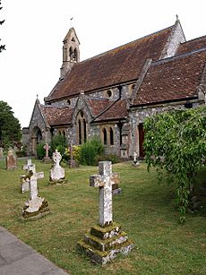
It's not clear if there was a Saxon church here, but there was a Norman church. In 1410, this church was completely destroyed. It was rebuilt later, but by 1853, it was in poor condition. So, the church was taken down, and a new one was built in 1858. It was designed by Thomas Henry Wyatt and cost £2,353. This new church is a Grade II listed building.
The south and west windows of the church have pieces of special glass from Salisbury Cathedral. These pieces were collected by Canon Stanley Baker from the street ditches in Salisbury. They had been thrown away after being removed from the cathedral in 1788. Canon Baker is buried in the churchyard. The church does not have any bells.
Schools in Laverstock
The parish of Laverstock has three primary schools. The first school in Laverstock village started in the 1830s. It moved into a new building in 1888 and is now called St Andrew's CE VA Primary School. Because of new housing developments, two more primary schools were built: Old Sarum Primary School and Greentrees Primary School. Greentrees Primary School has two sites in the Bishopdown area.
There are also two secondary schools located next to each other on Church Road. These schools serve a wide area:
- St Joseph's Catholic School, which is a voluntary aided school.
- Wyvern St Edmund's, which is a Church of England academy.
Special Natural Areas
Cockey Down, a grassy hill east of Laverstock, is a chalk down Site of Special Scientific Interest. This means it's a protected area because of its unique plants and animals. The River Bourne, a chalk stream that flows through the parish, is also part of a larger protected area. This river system is a Site of Special Scientific Interest and a Special Area of Conservation, important for its natural environment.
Freedom of the Parish Award
David Law, who used to be a parish councillor, received the Freedom of the Parish award on February 17, 2020. This award was given to him for his great service to the community and to the parish council.
 | Laphonza Butler |
 | Daisy Bates |
 | Elizabeth Piper Ensley |


