
Lawn Hill, Queensland facts for kids
Quick facts for kids Lawn HillQueensland |
|||||||||||||||
|---|---|---|---|---|---|---|---|---|---|---|---|---|---|---|---|
.jpg)
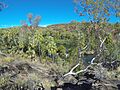
Lawn Hill Gorge
|
|||||||||||||||

Lawn Hill
Location in Queensland
|
|||||||||||||||
| Population | 63 (2021 census) | ||||||||||||||
| • Density | 0.00431/km2 (0.0112/sq mi) | ||||||||||||||
| Postcode(s) | 4825 | ||||||||||||||
| Area | 14,606.5 km2 (5,639.6 sq mi) | ||||||||||||||
| Time zone | AEST (UTC+10:00) | ||||||||||||||
| Location |
|
||||||||||||||
| LGA(s) |
|
||||||||||||||
| State electorate(s) | Traeger | ||||||||||||||
| Federal Division(s) | Kennedy | ||||||||||||||
|
|||||||||||||||
Lawn Hill is a remote area in Queensland, Australia. It's partly in the Shire of Burke and partly in the City of Mount Isa. This place is right on the border with the Northern Territory. In 2021, only 63 people lived here, making it a very quiet and spread-out community.
Contents
Exploring Lawn Hill's Geography
Lawn Hill is a huge area, bigger than many countries! It covers over 14,600 square kilometers, so it has many different types of land. Its western side shares a border with the Northern Territory.
Mountains and Ranges
Lawn Hill is home to several mountain ranges and peaks. These natural features add to the wild beauty of the area.
Some of the ranges you can find here are:
- Constance Range
- Edith Range
- Littles Range
- Smiths Range
And some of the mountains include:
- Fort William (180 meters high)
- Mount Caroline (245 meters high)
- Mount Oscar (115 meters high)
- Mount Steiglitz (81 meters high)
- Napoleon Bonnet (186 meters high)
- Point Watson (211 meters high)
- Mount Kay (270 meters high)
- Verdon Rock (150 meters high)
Wide Open Plains
Besides mountains, Lawn Hill also has large, flat areas called plains. These include:
- Burenda Plain
- Rankins Plain
- Wangunda Plain
Special Neighbourhoods
Within Lawn Hill, there are also smaller areas known as neighbourhoods:
- Mended Hill
- Pitchfork Camp
Boodjamulla National Park
A big part of Lawn Hill, stretching from the west to the south, is covered by the Boodjamulla National Park. This park is a protected area, meaning its natural beauty and wildlife are kept safe. It also includes special "Lawn Hill Resources Reserves."
A Look at Lawn Hill's Past
The land around Lawn Hill has a rich history, especially with Aboriginal people.
Traditional Languages
Two important Aboriginal languages were spoken in this region:
- The Waanyi language was spoken in the western parts of Lawn Hill Creek and the Nicholson River. This area stretched from the Queensland border towards places like Alexandria station and Doomadgee.
- The Yulluna language was spoken in areas near the Gulf of Carpentaria, including the Shire of Cloncurry.
Naming the Land
Many places in Lawn Hill got their names from early explorers and settlers. For example, Smiths Range was named by explorer William Landsborough in 1861. He was on an expedition looking for the famous explorers Burke and Wills.
The entire area of Lawn Hill is named after the Boodjamulla National Park. This park used to be called Lawn Hill National Park, which in turn got its name from a large farming property called Lawn Hill Station.
Protecting the Gorge
The beautiful Lawn Hill Gorge was once part of the Lawn Hill pastoral station. To protect this special place, Lawn Hill National Park was created in December 1984. Later, in March 1992, the park grew to include the amazing Riversleigh World Heritage Area.
Who Lives in Lawn Hill?
The number of people living in Lawn Hill has changed over the years:
- In 2011, Lawn Hill and nearby areas had 381 people.
- By 2016, the population of Lawn Hill itself was 19 people.
- In 2021, the population grew to 63 people.
Life and Work in Lawn Hill
Lawn Hill is mainly a rural area with several large properties called homesteads. These are like big farms or stations where people live and work.
Some of the homesteads in Lawn Hill include:
- Adels Grove
- Lawn Hill
- Old Herbert Vale
- Riversleigh
Community and Services
Even in remote areas like Lawn Hill, communities come together.
Church Services
The Uniting Church in Australia holds regular services at the campfire at Adels Grove. These services are provided by the McKay Patrol, which is a special aerial service. They use a small plane, a Cessna 182Q, to fly to remote areas. This allows them to offer spiritual and practical help to people living far from towns in north-west Queensland and the eastern Tablelands of the Northern Territory. They cover a huge area of about 625,000 square kilometers!
Amazing Places to Visit
Lawn Hill is known for its stunning natural attractions, especially for those who love the outdoors and history.
Boodjamulla National Park
The Boodjamulla National Park is a very popular spot. It features spectacular gorges, which are deep, narrow valleys with steep sides. The park also has impressive sandstone ranges and incredible fossils. Lawn Hill Creek flows through the park, creating the beautiful Lawn Hill Gorge. This gorge is like an oasis, filled with fresh water from springs and surrounded by lush green plants. It's a perfect place for wildlife to gather, and it's surrounded by tall sandstone cliffs.
Riversleigh World Heritage Area
Inside the south-east part of the national park is the Riversleigh World Heritage Area. This site is incredibly important because it contains fossils from about 25 million years ago! It's recognized as one of the most significant fossil sites in the world, especially for mammal fossils from a supercontinent called Gondwana. Before Gondwana broke apart, many unique animals lived there. At Riversleigh, scientists have found fossils of crocodiles, lizards, turtles, pythons, fish, snails, and even ancient birds.
Indarri Falls Lookout
You can also visit the Indarri Falls Lookout for amazing views of the landscape.
Images for kids
-
Lawn Hill Gorge is a beautiful oasis in the outback.
