
Lexington Reservoir facts for kids
Quick facts for kids Lexington Reservoir |
|
|---|---|
 |
|

Lexington Reservoir
Location in California

Lexington Reservoir
Location in the United States
|
|
| Location | Santa Cruz Mountains Santa Clara County, California |
| Coordinates | 37°11′21″N 121°59′17″W / 37.1892893°N 121.9881592°W |
| Type | Reservoir |
| Primary inflows | Los Gatos Creek |
| Primary outflows | Los Gatos Creek |
| Catchment area | 27.7 sq mi (72 km2) |
| Basin countries | United States |
| Surface area | 450 acres (1.8 km2) |
| Water volume | 21,430 acre⋅ft (26,430,000 m3) |
| Surface elevation | 666 ft (203 m) |

.JPG)
_Spillway,_emptying_into_Los_Gatos_Creek.JPG)


Lexington Reservoir is a large man-made lake located on the Los Gatos Creek. It is found near the town of Los Gatos, California. The lake was created by the James J. Lenihan Dam, which is a huge earthen dam about 195 ft (59 m) high. This reservoir is the third-largest in Santa Clara County.
Contents
Why Was Lexington Reservoir Built?
Lexington Reservoir is nestled in the foothills of the Santa Cruz Mountains. It sits at an elevation of about 645 feet (197 m). This reservoir is a very important part of the Santa Clara Valley Water District. It helps provide water to the homes and businesses in Silicon Valley.
State Route 17 runs right next to the dam. Alma Bridge Road goes around the eastern side of the reservoir. The reservoir is also part of the Lexington Reservoir County Park. This park has many hiking trails with great views of the lake and the surrounding area. The Los Gatos Creek Trail starts at the dam and follows the creek downstream.
History of Lexington Reservoir
Building the Dam
In 1943, the Santa Clara Valley Water District saw that the amount of well water in the Santa Clara Valley was getting low. This was because many orchards were growing in the area. They decided a new dam was needed on Los Gatos Creek. The main goal was to let water soak into the ground. This would help increase the amount of water available in wells.
Construction of the dam began in the spring of 1952. It was finished later that same year. Before building the dam, a part of State Route 17 had to be moved.
Towns Under the Water
When the reservoir was filled, it covered two small towns: Lexington and Alma. These towns were busiest in the mid-1800s. Each town had about 200 people living there. They had post offices, hotels, and saloons. There were also blacksmith shops and several redwood sawmills.
Lexington was a popular stop for stagecoaches. These coaches traveled between San Jose and Santa Cruz. It was a place where horses were changed to help the stagecoaches get over the mountains. Lexington became less important after 1880. This was when a new railroad bypassed the town. Alma also declined when Highway 17 was built in 1940, bypassing it. By 1950, only about 100 people lived in both communities combined.
Keeping the Dam Safe
The Lenihan Dam Outlet Project
In September 2007, the Santa Clara Valley Water District started a big project. It was called the "Lenihan Dam Outlet Project." This project was to replace an old pipe that ran through the bottom of the dam. This pipe carried water from the reservoir to Los Gatos Creek.
The old pipe was 48-inch (1,200 mm) wide and needed many repairs. It had even collapsed in some places. The new pipe is 54-inch (1,400 mm) wide. It also has new valves and a new control building. This larger pipe helps the reservoir drain water faster. This is very important during emergencies. For example, if there's a big earthquake that could crack the dam. Or during heavy winter storms that could cause floods in Los Gatos and Campbell.
The new pipe runs through a new tunnel. This tunnel is on the east side of the dam. The project was finished in the fall of 2009.
Fun at Lexington Reservoir County Park
Besides providing water, Lexington Reservoir is a great place for outdoor activities. The Santa Clara County Parks and Recreation Department manages the 914-acre (3.70 km2) park.
Activities at the Park
- Boating: You can go rowing and paddling on the lake.
- Fishing: The reservoir is stocked with fish like black bass, trout, bluegill, and crappie.
- Hiking: There are many trails for hiking and enjoying nature.
- Picnicking: The park has areas perfect for a picnic with family and friends.
Nature and Geology
The park is home to different types of natural areas. You can find redwood forests, chaparral, grasslands, and mixed conifer habitats. A part of the famous San Andreas Fault also crosses Los Gatos Creek just south of the reservoir.
When the water level in Lexington Reservoir is low, you can sometimes see parts of the old roads. These roads were used when the dam was built. You might even see some building foundations from the old towns of Lexington and Alma. These old structures have only been visible a few times since the dam was built.
Images for kids
-
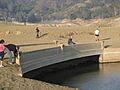
A sunken bridge across Black Creek, which was exposed during the pipe replacement project (2008).
-
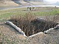
A building foundation, which was exposed during the pipe replacement project (2008).


