
Liberty, South Carolina facts for kids
Quick facts for kids
Liberty, South Carolina
|
|||
|---|---|---|---|

Top, left to right: Downtown Liberty, railroad tracks, West Front Street, Liberty High School
|
|||
|
|||

Location of Liberty, South Carolina
|
|||
| Country | United States | ||
| State | South Carolina | ||
| County | Pickens | ||
| Government | |||
| • Type | Mayor–council government | ||
| • Body | Liberty City Council | ||
| Area | |||
| • Total | 4.54 sq mi (11.76 km2) | ||
| • Land | 4.53 sq mi (11.73 km2) | ||
| • Water | 0.01 sq mi (0.03 km2) | ||
| Elevation | 984 ft (300 m) | ||
| Population
(2020)
|
|||
| • Total | 3,366 | ||
| • Density | 743.54/sq mi (287.08/km2) | ||
| Time zone | UTC−5 (Eastern (EST)) | ||
| • Summer (DST) | UTC−4 (EDT) | ||
| ZIP code |
29657
|
||
| Area codes | 864, 821 | ||
| FIPS code | 45-41380 | ||
| GNIS feature ID | 1246350 | ||
| Website | www.libertysc.com | ||


Liberty is a city in Pickens County, South Carolina, United States. It is part of the larger Metropolitan Statistical Area. The city officially became a chartered city on March 2, 1876.
Contents
What's in a Name? The Story of Liberty
The exact reason Liberty got its name has been a mystery. There are no clear historical records explaining it. The most popular story, though probably a legend, comes from Mrs. Annie Craig in 1936. She said that after the American Revolutionary War, a religious meeting was held near a spring. News arrived that the colonies had won their independence. The church there was named Liberty, and so was the spring. This led to the area being called Liberty.
Some people thought Liberty was once called Salubrity Springs. However, old land records do not support this idea. Many records mention "Liberty Spring," but none say "Salubrity Spring." The name Salubrity came from a farm bought by Rev. Allen Fuller in 1837. He opened a post office in his home in 1839, calling it the Salubrity Post Office. This post office closed in 1876, shortly after the town of Liberty was officially chartered.
Liberty's Past: A Look at History
Early Days: From Cherokee Land to New Settlements
The land where Liberty stands today was once a hunting ground for the Cherokee Native Americans. The Lower Hill Cherokees had villages along the rivers. They grew crops and hunted deer and buffalo. They believed the foothills were sacred hunting grounds.
Around 1540, Hernando DeSoto and his Spanish explorers might have been the first Europeans to visit this area. Later, English traders came from Charles Town and Savannah. They traded guns, horses, cloth, and liquor with the Cherokee for animal skins. In 1753, British colonists built Fort Prince George, the first white settlement in Pickens County.
During the American Revolution, the Cherokee supported the British. Because of this, South Carolina patriots made them give up much of their land. This happened with the Treaty of DeWitt's Corner in 1777. American settlers began moving into the area in larger numbers around the mid-1780s.
By 1800, Liberty, then known as Liberty Spring, was part of the new Pendleton District. This district included much of what is now Anderson, Oconee, and Pickens Counties. In the years before the Civil War, most people in Liberty Spring were subsistence farmers. This means they grew only enough food to feed their families. Few could afford slaves, and most farmers worked their own land. Roads were poor, making trade with other towns difficult.
The Civil War and Reconstruction Era
In 1860, leaders from Pickens County voted for South Carolina to leave the Union. Many men from the area joined the Confederate army. Families often lost several sons in the war. Women who stayed home faced shortages of food and supplies.
After the war, Pickens District was under military rule by Union troops. South Carolina rejoined the Union in 1868. Soon after, Pickens District was divided into Pickens and Oconee Counties. The period after the war, called Reconstruction, was hard for Southerners. Union troops sometimes looted farms. The government was largely controlled by Northerners who moved South. Reconstruction ended in South Carolina around 1877.
How Liberty Grew: The Founders' Era
Liberty officially became a town after the Charlotte-Atlanta Airline Railway was built in the early 1870s. A lawyer for the railroad, William Easley, helped lay tracks through southern Pickens County. The towns of Liberty, Easley, and Central grew along these tracks.
In 1873, Liberty Station was built. Mrs. Catherine Templeton gave her land to the railroad. John T. Boggs opened the new Liberty Post Office that same year. He became the town's first postmaster. Liberty was officially chartered on March 2, 1876. The town center was on Mrs. Templeton's former land.
In 1877, James Avenger became the town's first marshall. This job was like today's chief of police. W.E. Holcombe was elected the first mayor in 1876. He was a lawyer and former state senator. Early mayors handled town business from their homes. Several schools were already open, often funded by the community or churches. The Liberty First Baptist Church was even older than the city. It had a congregation as early as 1802. The Liberty Presbyterian Church was built in 1883.
The Textile Era: Mills and Modern Changes
A big change for Liberty came in 1901 when Mr. Jeptha P. Smith started the first cotton mill. He named it the Liberty Mill. The mill had machines for processing cotton. Eighteen houses and two overseer houses were built nearby for the workers. This was called a mill village.
A second cotton mill, the Calumet Mill, was built in 1905. It was later renamed the Maplecroft Mill. By 1920, both mills were owned by Woodside Mills. The first mill became Woodside Liberty Plant #1, and the second was Plant #2. Woodside Mills ran the plants until 1956. Then, Dan River Mills bought them. In the 1970s, the mills employed over a thousand workers. They were the world's largest producers of Oxford fabric. Greenwood Mills bought the mills in the early 1980s. The local textile industry declined in the 1990s due to foreign competition. The smaller mill was torn down in 2013. The larger mill is also being prepared for demolition.
The growth of cotton mills changed how people lived. Many moved from farms to mill villages. They went from growing their own food to earning hourly wages. Mill work was tough, with long hours in hot rooms. But most workers were happy to have a job. Often, both husbands and wives worked in the same mill.
Many other changes happened during this time. Electricity came to Liberty in 1910. Mr. J. Warren Smith installed generators for street lights and shops. By 1928, Duke Power took over. The Liberty Fire Department started in 1925, with J. Warren Smith as the first chief. The current fire station was built in 1974.
The first town library opened in 1947. It was a small room in City Hall. The Sarlin Community Library, used today, was built in 1966. Liberty's police department was organized in the 1920s. It had a chief and two policemen. Telephone service arrived in 1902. Southern Bell put a switchboard in the post office building. The first water plant was built in 1918. It supplied water to about one hundred homes. A newer water plant was built in 1956.
Today, the former Mohawk Carpet plant is home to Southern Vinyl Windows & Doors. This company is a major employer in the area.
Where is Liberty? Geography Facts
Liberty is located at 34°47′18″N 82°41′42″W / 34.78833°N 82.69500°W.
The United States Census Bureau says the town covers about 4.3 square miles (11.76 square kilometers). All of this area is land.
Who Lives in Liberty? Demographics
| Historical population | |||
|---|---|---|---|
| Census | Pop. | %± | |
| 1880 | 149 | — | |
| 1890 | 211 | 41.6% | |
| 1900 | 368 | 74.4% | |
| 1910 | 1,058 | 187.5% | |
| 1920 | 1,705 | 61.2% | |
| 1930 | 2,128 | 24.8% | |
| 1940 | 2,240 | 5.3% | |
| 1950 | 2,291 | 2.3% | |
| 1960 | 2,657 | 16.0% | |
| 1970 | 2,860 | 7.6% | |
| 1980 | 3,167 | 10.7% | |
| 1990 | 3,228 | 1.9% | |
| 2000 | 3,009 | −6.8% | |
| 2010 | 3,269 | 8.6% | |
| 2020 | 3,366 | 3.0% | |
| U.S. Decennial Census | |||
Liberty's Population in 2020
| Race | Num. | Perc. |
|---|---|---|
| White (non-Hispanic) | 2,795 | 83.04% |
| Black or African American (non-Hispanic) | 212 | 6.3% |
| Native American | 24 | 0.71% |
| Asian | 16 | 0.48% |
| Other/Mixed | 173 | 5.14% |
| Hispanic or Latino | 146 | 4.34% |
As of the 2020 United States census, there were 3,366 people living in Liberty. There were 1,396 households and 929 families.
Fun in Liberty: Arts and Culture
Liberty Idol was a singing competition like the TV show American Idol. It started in 2006 and ran for six seasons. Crowds for Liberty Idol sometimes reached 3,500 people!
Liberty on Screen: Movies Filmed Here
Several movies have been filmed in Liberty and nearby areas.
- The film The Midnight Man (1974), starring Cameron Mitchell, was filmed in Liberty, Six Mile, and Clemson.
- A large part of the 1999 movie Chill Factor, with Cuba Gooding Jr. and Skeet Ulrich, was filmed in Liberty.
Learning in Liberty: Education
Liberty is part of the School District of Pickens County. The city has several schools:
- A primary school (grades PK-2)
- An elementary school (grades 3-5)
- One middle school (grades 6-8)
- One high school (grades 9-12)
In 2011, two new schools were built. Liberty Elementary School has 842 students. Liberty Middle School has 731 students. Liberty High School has 690 students. The mascots for the schools are:
- Liberty High School: Red Devils
- Liberty Elementary School: Liberty Lab
- Liberty Middle School: Falcons
- Liberty Primary School: Wolfpack
Liberty also has a public library, the Sarlin Community Library. It is a branch of the Pickens County Library System.
Images for kids
-
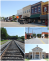
Top, left to right: Downtown Liberty, railroad tracks, West Front Street, Liberty High School
-

Flag of Liberty, South Carolina
-
Liberty, SC City Seal
-
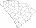
Location of Liberty, South Carolina
See also
 In Spanish: Liberty (Carolina del Sur) para niños
