
List of Indiana state historical markers in Marion County facts for kids

This page lists the Indiana state historical markers in Marion County. These markers are special signs that tell us about important places and events in history. As of November 2023, there are 109 of these markers in Marion County, Indiana.
The Indiana Historical Bureau places these official markers. They help everyone learn about the past. Below, you'll find details about each marker, like its name, when it was put up, and what historical topic it covers.
Discovering Marion County's History Through Markers
Marion County is full of history, and these markers help us explore it! They cover many interesting topics, from famous people and important buildings to big events and local communities. Let's look at some of the key historical markers you can find.
Government and Politics Markers
Many markers highlight important moments in Indiana's government and the people who shaped its politics.
Indiana's State Capitol and Leaders
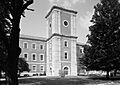
- State Capitol (1946): This marker is at the east entrance of the Statehouse. It tells us about Indiana's main government building, which is important for politics and architecture.
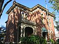
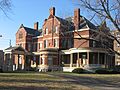
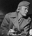
- Brig. General Benjamin Harrison 1833–1901 (1963): You can find this marker at the President Benjamin Harrison Home. It honors Benjamin Harrison, who was a U.S. President and a military general.
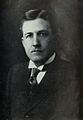
- Home of Charles Warren Fairbanks (1966): This marker is on the front lawn of a building at 30th and Meridian Streets. It tells about Charles Warren Fairbanks, an important political figure.
- First Lady Caroline Harrison (2017): Located at the Benjamin Harrison Presidential Site, this marker celebrates Caroline Harrison, the wife of President Benjamin Harrison, and her contributions to arts and culture.
- Grace Julian Clarke (2020): This marker at 115 S. Audubon Road honors Grace Julian Clarke, a significant woman in politics.
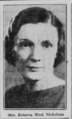
- Rep. Roberta West Nicholson (2021): Found at the English Foundation Building, this marker recognizes Roberta West Nicholson, a woman who served in politics.
- Harriette Bailey Conn (2021): This marker at 1 North Capitol Avenue celebrates Harriette Bailey Conn, an African American woman who was important in politics.
- Indiana Woman's Suffrage (2021): Located at 200 West Washington Street, this marker highlights the history of women gaining the right to vote in Indiana.
Key Political Events
- Lincoln to the Citizens of Indiana (1961): This marker at 402 W. Washington Street remembers when Abraham Lincoln spoke to the people of Indiana.
- Robert F. Kennedy on Death of Martin L. King (2005): This marker in King Park remembers Robert F. Kennedy's speech after Martin Luther King Jr.'s passing. It's important for understanding civil rights and politics.
- The American Legion (2020): This marker at 777 N. Meridian Street recognizes The American Legion, a group important to military history and government.
Military History Markers
Several markers tell stories of military events and figures in Marion County.
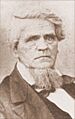
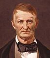
- Anthony Wayne 1745–1796 (1960): This marker is on the front lawn of George Washington High School. It honors Anthony Wayne, a key military figure in early American history.
- Camp Morton 1861–1865 (1962): Located at Herron-Morton Place Historic Park, this marker tells about Camp Morton, which was a military camp during the Civil War.
- Civil War Arsenal 1861–1864 (1964): This marker at the Statehouse east entrance remembers a place where military supplies were made during the Civil War.
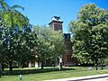
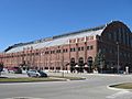
- Former U.S. Arsenal (1976): This marker is on the campus of Arsenal Technical High School, marking the site of a former U.S. military arsenal.
- Fort Benjamin Harrison (1996): This marker on Otis Avenue tells about Fort Benjamin Harrison, a significant military base.
- 28th Regiment USCT (2004): This marker at Virginia Avenue and McCarty Street honors the 28th Regiment of the United States Colored Troops, an African American military unit.
- WWI Aviation Repair Depot (2018): This marker in Speedway tells about a place where airplanes were repaired during World War I, linking military history with industry and transportation.
Community and Neighborhood Markers
These markers highlight the development of different communities and neighborhoods in Marion County.
- Woodruff Place (1976): This marker is in Woodruff Place, a historic neighborhood known for its unique architecture.
- North Meridian Street Historic District (1991): There are two markers for this district, one at Westfield Boulevard and another at 40th Street. They highlight a historic area with beautiful buildings.
- Ransom Place Historic District (1993): This marker at 830 Dr. Martin Luther King, Jr. Street tells about Ransom Place, an important historic district for African American history.
- Indiana Avenue (1994): Located on a traffic island at West Street and Indiana Avenue, this marker celebrates Indiana Avenue, a historic area important to African American culture.
- The Old Northside (1995): Two markers, one at 1456 Central Avenue and another at 12th and Delaware Streets, describe this historic neighborhood known for its architecture.
- Lockerbie Square (1998): This marker at Lockerbie Street and N. East Street tells about Lockerbie Square, another historic neighborhood with unique buildings.
- Holy Rosary–Danish Church Historic District (2000): This marker at S. East Street and S. Stevens Street highlights a historic district with ties to Danish and religious communities.
- Calvin Fletcher (2006): This marker at Virginia Avenue and East Street tells about Calvin Fletcher, who was important in the development of neighborhoods and African American history.
- The Syrian Quarter (2023): Located at 500 S. Capitol Avenue, this marker tells about the Syrian Quarter, an area important to immigrant communities and their culture.
Science, Medicine, and Innovation Markers
These markers celebrate advancements in science, medicine, and new inventions.
- Milestones in Nursing (1968): This marker at Eskenazi Hospital's Nursing Museum entrance highlights important moments in the history of nursing.
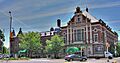
- Indianapolis Motor Speedway (1975): Located at the Indianapolis Motor Speedway Museum, this marker celebrates the Speedway's role in sports and innovation, especially in transportation and engineering.
- 1907 Indiana Eugenics Law (2007): This marker on the lawn of the Indiana State Library tells about a past law related to science and medicine.
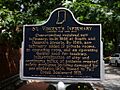
- St. Vincent's Infirmary (2007): This marker at 536 E. Vermont Street tells about St. Vincent's Infirmary, an important place in the history of medicine.
- St. Vincent's Hospital (2013): Located at the Illinois-Fall Creek Center, this marker continues the story of St. Vincent's Hospital's role in medicine.
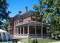
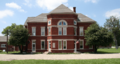
- Central State Hospital (2016): This marker at the Central State Mansion tells about Central State Hospital, important for the history of medicine and education.
- Lincoln Hospital, 1909–ca. 1915 (2018): This marker at 1109 N. Senate Avenue tells about Lincoln Hospital, an important medical facility from the past.
- Pathological Department / Old Pathology Building (2019): Located at 3045 W. Vermont Street, this marker highlights a building important for medical history and science.
- Dr. Amelia Keller, 1871–1943 (2022): This marker at 988 W. Walnut Street celebrates Dr. Amelia Keller, a woman important in science, medicine, and politics.
- Hook's Drug Stores (2022): This marker at 1101 S. East Street tells about Hook's Drug Stores, important for business, industry, and the history of medicine.
- Leedy Manufacturing Company (2021): This marker at 1601 South Barth Avenue tells about a company important for business, industry, arts, and inventions.
Arts, Culture, and Education Markers
Many markers celebrate artists, cultural institutions, and educational milestones.
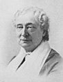
- Sarah T. Bolton (1960): This marker near Sarah T. Bolton Park honors Sarah T. Bolton, a woman important in arts and culture.
- William Forsyth 1854–1935 (1984): This marker in Brown's Corner Park celebrates William Forsyth, a notable artist.
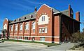
- Crispus Attucks High School (1992): Located at 1140 Dr. Martin Luther King, Jr. Street, this marker tells about Crispus Attucks High School, an important school for African American education and architecture.
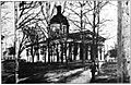
- North Western Christian University (1992): This marker at 1325 N. College Avenue tells about the early history of Butler University, focusing on education and religion.
- Site of Golden Hill Totem Pole (1992): This marker in the Golden Hill neighborhood tells about a totem pole, linking to arts, culture, and Native American history.
- Willard Park (1993, 2019): Two markers at 1901 E. Washington Street tell about Willard Park, which is important for education and community.
- Indiana School for the Blind (1994): This marker at 7725 N. College Avenue tells about this important school for education and government institutions.
- Ovid Butler, Sr. (2007): This marker at 1306 North Park Avenue celebrates Ovid Butler, Sr., important for education and newspapers.
- Indianapolis Propylaeum (2009): This marker at 1410 N. Delaware Street tells about the Propylaeum, important for women's history, architecture, and arts.
- T. C. Steele Studio and Herron (2015): This marker at 110 E 16th Street tells about T. C. Steele, an important artist, and Herron, an art school.
- Senate Avenue YMCA (2016): Located at 420 N. Senate Ave., this marker tells about the Senate Avenue YMCA, important for African American education and architecture.
- James Whitcomb Riley Home (2018): This marker at 528 Lockerbie Street tells about the home of James Whitcomb Riley, a famous poet, and its architectural significance.
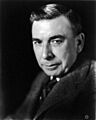
- Meredith Nicholson (2020): This marker at 1500 N. Delaware Street celebrates Meredith Nicholson, a notable figure in literature.
- Booth Tarkington (2019, dedicated 2020): Located at 4270 N. Meridian Street, this marker honors Booth Tarkington, a famous writer important to literature and arts.
- John Hope School No. 26 (2022): This marker at 1301 E. 16th Street tells about John Hope School No. 26, important for education and African American history.
- Sigma Gamma Rho (2022): This marker at 5350 E. University Avenue celebrates Sigma Gamma Rho, an African American sorority important for education.
- Felrath Hines, Jr. (2023): Located at 1140 Dr. MLK Jr Street, this marker honors Felrath Hines, Jr., an important African American artist.
- Janet Flanner (2023): This marker at 4061 N. Illinois Street celebrates Janet Flanner, a woman important in newspapers, media, and arts.
- John Leslie “Wes” Montgomery (2023): This marker at the northwest corner of 10th St. and Bellafontaine St. honors Wes Montgomery, a famous African American musician.
Transportation and Industry Markers
These markers highlight how people and goods moved around, and the businesses that shaped the area.
- Toll House - Michigan Road (1961): This marker at 4702 N. Michigan Road tells about a toll house on the Michigan Road, important for transportation and business.
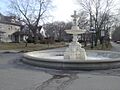
- The Central Canal (1966): This marker at Illinois Street and Westfield Boulevard tells about the Central Canal, important for transportation and industry.
- Site of the Central Canal (1992): This marker behind the North State Office Building also tells about the Central Canal.
- Joseph W. Summers Memorial Bridge (1995): Two markers on Meridian Street at Fall Creek tell about this bridge, important for transportation and architecture.
- German Greenhouses and Truck Gardens (1998): This marker in Bluff Park tells about German immigrant communities, their businesses, and agriculture.
- Brookville Road (2004): This marker at 10622 Brookville Road tells about Brookville Road, important for transportation and business.
- Allison Machine Shop (2015): This marker in Speedway tells about the Allison Machine Shop, important for business, industry, and military history.
- "Cannon Ball" Baker (2017): This marker at 902 E Garfield Drive celebrates "Cannon Ball" Baker, known for his achievements in transportation.
- Andrew "Bo" Foster (2023): This marker at 2160 N. Illinois Street honors Andrew "Bo" Foster, important for business, industry, and African American history.
Other Important Historical Markers
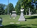
- Mary Bryan, Pioneer Woman (1975): This marker in a cemetery at Pine Street and Southport Road tells about Mary Bryan, an important pioneer woman.
- Crown Hill (1976): This marker in Crown Hill Cemetery tells about this historic cemetery.
- The Indianapolis Times (1979, 2013): Two markers, one at 300 block of W. Maryland Street and another near the Westin Indianapolis Hotel, tell about The Indianapolis Times, an important newspaper.
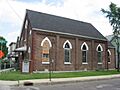
- First Presbyterian Church of Southport (1983): This marker at 6200 McFarland Road tells about this church, important for religion.
- Macedonian Tribune (1990): This marker at West and Washington streets tells about the Macedonian Tribune, a newspaper important for immigrant groups.
- Bulgarian Orthodox Church (1995): This marker on the campus of Indiana University – Purdue University Indianapolis tells about this church, important for religion and immigrant groups.
- Romanian Orthodox Church (1998, 2019): Two markers in White River State Park tell about this church, important for immigrant groups and religion.
- Indianapolis Fire Department / Bowen-Merrill Fire (1999): This marker at 2 W. Washington Street tells about the fire department and a significant fire.
- Athenaeum (1999): This marker at 401 E. Michigan Street tells about the Athenaeum, important for German immigrant groups and architecture.
- Market Street Temple (1999): This marker at 435 E. Market Street tells about this temple, important for religion and immigrant groups.
- Widows and Orphans Friends' Society (2003): This marker on Capitol Avenue tells about a society that helped women, widows, and orphans.
- Greek Orthodox Church (2003, 2020): Two markers beside the Indiana Historical Society tell about the Greek Orthodox Church, important for religion and immigrant groups.
- John Muir in Indianapolis (2004): This marker near Illinois and Merrill Streets tells about John Muir, important for nature and politics.
- Marion County Girl Scouts (2004): This marker at Irvington Presbyterian Church celebrates the Girl Scouts, important for women and arts.
- Zerelda G. Wallace (2004): This marker at Central Christian Church honors Zerelda G. Wallace, a woman important in religion.
- Calvin Fletcher (2006): This marker at Virginia Avenue and East Street tells about Calvin Fletcher, important for African American history and military.
- John Freeman (2006): This marker on Pennsylvania Street tells about John Freeman, important for the Underground Railroad and African American history.
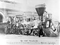
- The Lincoln Funeral Train (2009): This marker on the southern lawn of the Statehouse tells about Abraham Lincoln's funeral train.
- Bethel African Methodist Episcopal Church (2009): This marker at 414 W. Vermont Street tells about this church, important for African American history, religion, and the Underground Railroad.
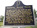
- Major Taylor (2009): This marker at 38th Street and the Monon Trail celebrates Major Taylor, an African American sports figure.
- Isaac Blackford (2011): This marker at Blackford Street and New York Street tells about Isaac Blackford, an important legal figure.
- Washington Park Baseball (2011): This marker at 1200 W. Washington Street tells about baseball played at Washington Park.
- German Newspapers' Demise (2017): This marker at 41 S. Delaware Street tells about the end of German newspapers in the area.
- May Wright Sewall (1844–1920) (2019): This marker at Veterans Memorial Plaza honors May Wright Sewall, an important woman in history.
- Lt. Col. Joseph H. Ward, M.D, 1872–1952 (2019): This marker at West 21st Street and North Boulevard Place honors Lt. Col. Joseph H. Ward, a doctor and military figure.
- Newby Oval (2021): This marker on the Fall Creek Trail tells about Newby Oval, a place important for sports.
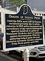
- Origins of Indiana Pride - Indiana LGBTQ Pride (2021): This marker at 40 Monument Circle tells about the history of LGBTQ Pride in Indiana.
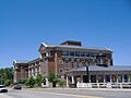
- Hinkle Fieldhouse (2023): This marker at 510 W 49th Street tells about Hinkle Fieldhouse, important for sports, architecture, and education.
- Lynching of John Tucker (2023): This marker at 110 W Washington Street tells about a past legal event involving John Tucker and African American history.
- South Side Turnverein (2023): This marker at 306 Prospect Street tells about the South Side Turnverein Hall, important for sports, architecture, and immigrant groups.
Images for kids
-
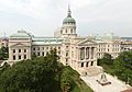
Indiana State Capitol Building
-
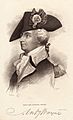
Anthony Wayne
-
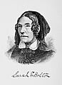
Sarah T. Bolton
-
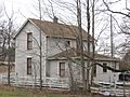
Michigan Road Toll House
-
Camp Morton
-
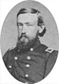
Brig. General Benjamin Harrison
-
Civil War Arsenal at the Statehouse
-

The Central Canal
-
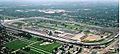
Indianapolis Motor Speedway
-
Arsenal Technical High School
-
Crown Hill Cemetery
-
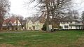
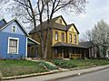
Woodruff Place
-
North Meridian Street Historic District
-
North Meridian Street Historic District
-
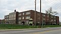
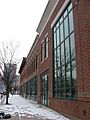
Crispus Attucks High School
-
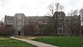
North Western Christian University
-
Site of the Central Canal
-
Ransom Place Historic District
-
Indiana Avenue
-
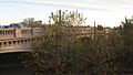
Joseph W. Summers Memorial Bridge
-
Joseph W. Summers Memorial Bridge
-
The Old Northside
-
The Old Northside
-
Fort Benjamin Harrison
-

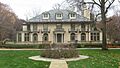
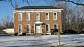
Bates-Hendricks House
-

Indiana Federation of Colored Women's Clubs
-
Lockerbie Square
-
Athenaeum
-
Holy Rosary–Danish Church Historic District
-
Greek Orthodox Church
-
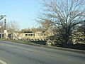
Brookville Road
-
John Muir
-
Zerelda G. Wallace
-
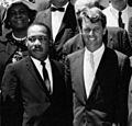
Robert F. Kennedy and Martin Luther King Jr.
-
Ovid Butler, Sr.
-
St. Vincent's Infirmary
-
Lincoln Funeral Train
-
Bethel African Methodist Episcopal Church
-
Major Taylor
-
Indianapolis Propylaeum
-
Isaac Blackford
-
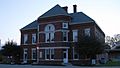
Central State Hospital
-
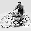
"Cannon Ball" Baker
-
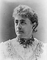
First Lady Caroline Harrison
-
James Whitcomb Riley Home
-
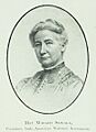
May Wright Sewall
-
Pathological Department / Old Pathology Building
-
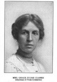
Grace Julian Clarke
-
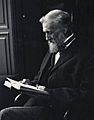
Meredith Nicholson
-
Booth Tarkington
-
Rep. Roberta West Nicholson
-
Origins of Indiana Pride
-

Leedy Manufacturing Company
-
Janet Flanner
-
Hinkle Fieldhouse
-
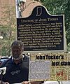
John Tucker Memorial
-
South Side Turnverein
-
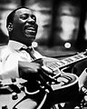
Wes Montgomery


_(2).jpg)


.jpg)
.jpg)


.jpg)
See also
- List of Indiana state historical markers
- National Register of Historic Places listings in Marion County, Indiana
