Southport, Indiana facts for kids
Quick facts for kids
Southport, Indiana
|
|
|---|---|

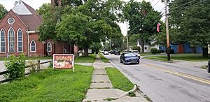
Bethel Community Church and Southport Farmers Market
|
|

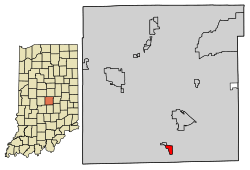
Location in Marion County, Indiana
|
|
| Country | United States |
| State | Indiana |
| County | Marion |
| Government | |
| • Type | City Council |
| Area | |
| • Total | 0.63 sq mi (1.63 km2) |
| • Land | 0.63 sq mi (1.63 km2) |
| • Water | 0.00 sq mi (0.00 km2) 0% |
| Elevation | 781 ft (238 m) |
| Population
(2020)
|
|
| • Total | 2,123 |
| • Density | 3,380.57/sq mi (1,306.09/km2) |
| Time zone | UTC-5 (EST) |
| • Summer (DST) | UTC-4 (EDT) |
| ZIP code |
46227
|
| Area code(s) | 317 |
| FIPS code | 18-71486 |
| GNIS feature ID | 2395920 |
Southport is a small city in Marion County, Indiana, United States. It's considered an "excluded city" within the Unigov system, which means it has its own local government even though it's part of a larger county government. In 2020, about 2,123 people lived there. This was an increase from 1,712 people in 2010.
Contents
Southport's Story
Southport was once a thick forest before the first European American settlers arrived in the 1820s. Some of the early families included Jacob Smock and Randall Litzey in 1822, Samuel Brewer in 1823, Benjamin McFarland in 1826, and Samuel and Mary Bryan in 1828. Mary Bryan is known as one of the first European American women to travel across the Cumberland Mountains.
By 1828, Southport had become an important stop for stagecoaches traveling on the road between Madison and Indianapolis. The town officially began in 1832, and its layout was planned out in 1852.
In 1847, the Jeffersonville, Madison and Indianapolis Railroad opened a railway line through Southport. This brought more people and businesses to the town, helping it grow. By 1884, Southport had a population of 388 people, and by 1960, it had grown to 892. Southport even had its own post office until 1960.
Where is Southport?
Southport is located in the southern part of Marion County, Indiana. To its north, you'll find the town of Homecroft. If you travel about 8 miles (13 km) north, you'll reach Downtown Indianapolis.
The U.S. Census Bureau says that Southport covers a total area of about 0.63 square miles (1.63 square kilometers), and all of this area is land. A small stream called Little Buck Creek flows through the northern part of the town, heading west towards the White River.
Who Lives in Southport?
| Historical population | |||
|---|---|---|---|
| Census | Pop. | %± | |
| 1880 | 388 | — | |
| 1890 | 324 | −16.5% | |
| 1900 | 285 | −12.0% | |
| 1910 | 352 | 23.5% | |
| 1920 | 458 | 30.1% | |
| 1930 | 521 | 13.8% | |
| 1940 | 549 | 5.4% | |
| 1950 | 730 | 33.0% | |
| 1960 | 892 | 22.2% | |
| 1970 | 2,342 | 162.6% | |
| 1980 | 2,266 | −3.2% | |
| 1990 | 1,969 | −13.1% | |
| 2000 | 1,852 | −5.9% | |
| 2010 | 1,712 | −7.6% | |
| 2020 | 2,123 | 24.0% | |
| U.S. Decennial Census | |||
Southport's Population in 2010
According to the census from 2010, there were 1,712 people living in Southport. These people lived in 696 households, and 484 of those were families. The city had about 2,717 people per square mile (1,049 people per square kilometer). There were 763 homes in total.
About 30% of the households had children under 18 living with them. Most households (51.3%) were married couples living together. About 24% of all households were made up of people living alone.
The average age of people in Southport was 41.3 years old. About 22.1% of residents were under 18, and 15.7% were 65 or older. The population was almost evenly split between males (48.1%) and females (51.9%).
Learning in Southport
Southport is part of the Metropolitan School District of Perry Township. Southport Elementary School is located right within the city's boundaries. The Southport branch of the Indianapolis Public Library is also very close, just west of the city's edge on Stop 11 Road, offering books and resources for everyone.
See also
 In Spanish: Southport (Indiana) para niños
 | Janet Taylor Pickett |
 | Synthia Saint James |
 | Howardena Pindell |
 | Faith Ringgold |


