
List of earthquakes in South Carolina facts for kids
South Carolina is a state that experiences earthquakes, especially along its central coastline near Charleston. It's actually the most active state for earthquakes on the East Coast of the United States! The biggest earthquake ever to hit the Eastern U.S. was the Charleston earthquake of 1886. It had a magnitude of 7.3, which is very strong. This quake sadly killed at least 60 people and caused a lot of damage to the city. Even after the main quake, smaller shakes called aftershocks continued for years.
It's tricky for scientists to study the cracks in the Earth's crust, called faults, in this area. That's because they are buried deep under thick layers of sand and dirt. Many of these ancient faults are found within the large pieces of the Earth's crust, called tectonic plates, rather than at their edges. Earthquakes as big as the 1886 one have happened in coastal South Carolina before, but only every few centuries or thousands of years. In recent times, smaller earthquakes that cause some damage happen every 10 to 20 years. For example, one happened in 2014 with a magnitude of 4.1. Even smaller quakes are felt every year or two. Interestingly, an earthquake in the Eastern U.S. can shake an area up to ten times larger than a similar earthquake on the West Coast!
Contents
Why Earthquakes Happen in South Carolina
Earthquakes start deep underground in the solid rock, called bedrock. Most of the bedrock under Charleston was formed a very long time ago, about 500 to 300 million years ago. This happened when continents crashed together to create a huge landmass called a supercontinent, which also formed the Appalachian Mountains. Later, about 200 million years ago, this supercontinent broke apart. This created what we now know as the southeastern U.S., the Atlantic Ocean, and Africa. Today, the Charleston area is very far from the nearest plate boundaries, which are in the Caribbean Sea.
Understanding Faults and Quakes
Where tectonic plates meet, it's easier to understand how earthquakes are linked to faults. But in the Charleston area, it's a bit of a mystery. The bedrock here has many faults, mostly from when the Appalachians formed and the Atlantic Ocean began. However, these faults are hidden under layers of sand, silt, clay, and soft rocks that can be up to 3 kilometers (2 miles) thick! Because of this, scientists can't easily connect most of the earthquakes in the area to specific faults. So, the best way to know about earthquake risks in South Carolina is to study the earthquakes themselves.
Major Earthquakes in South Carolina
The Great Charleston Earthquake of 1886
The 1886 Charleston earthquake was one of the biggest earthquakes in United States history. It caused an estimated $23 million in damage, which would be a huge amount of money today! Charleston and nearby cities suffered the most damage, but people as far as 160 kilometers (100 miles) away felt strong shaking. Many of the strongest earthquakes in South Carolina have happened near Charleston.

.jpg)
The main shock of the August 31, 1886, earthquake happened at 9:51 p.m. At first, people in Charleston felt a slight tremor, then heard a sound like something heavy rolling. The sound grew into a roar, and everything started to shake violently. The main shock lasted about 35 to 40 seconds. A strong aftershock followed 8 minutes later, and six more shocks happened in the next 24 hours. Almost every building was damaged, and many were completely destroyed. About 14,000 chimneys fell down! The shaking was so intense that it was rated as a "X" on the Mercalli intensity scale, which means extreme damage.
About 60 people died from falling buildings, and many more were hurt. Cities within 160 kilometers (100 miles) like Columbia, South Carolina, Augusta, Georgia, and Savannah, Georgia also saw damage. The earthquake was felt over a huge area, more than 5 million square kilometers (2 million square miles)! People felt it in distant places like New York City, Boston, Massachusetts, Milwaukee, Wisconsin, Havana, Cuba, and even Bermuda. Parts of 30 states and Ontario, Canada felt the main earthquake.
Strong aftershocks continued for months. Two big ones were felt on October 22, 1886, and another on November 5. The first one was felt strongly in Charleston, Atlanta, and Augusta. The second one was even stronger in Summerville, South Carolina, which had already been badly hit by the August 31 earthquake. The November 5 tremor was also strong in Charleston. These aftershocks were felt over an area of about 78,000 square kilometers (30,000 square miles).
Other Notable Earthquakes
South Carolina has experienced many other earthquakes throughout its history. Here are a few examples:
1860 and Early 1900s Quakes
On January 26, 1860, a strong earthquake was felt across South Carolina and as far away as Macon, Georgia. People described it as the "severest one felt in many years." In 1903, houses near the South Carolina-Georgia border shook strongly. Charleston, Columbia, and Augusta also felt it. A moderate quake in 1907 affected Charleston, Augusta, and Savannah, causing dishes to rattle and objects to fall. In 1912, a stronger quake damaged chimneys in Summerville and was felt over a large area, including parts of Georgia and North Carolina.
Quakes in the Mid-1900s
In 1913, the Union County area had an earthquake that cracked brick buildings and damaged chimneys. It was felt over about 111,000 square kilometers (43,000 square miles). Another quake in 1914 affected Summerville, displacing pictures on walls. People heard a noise like a train before the shaking. In 1924, an earthquake centered in Pickens County shook most of South Carolina, western North Carolina, and parts of Georgia and Tennessee. Buildings shook and furniture overturned.
On July 26, 1945, an earthquake near Lake Murray was felt over 65,000 square kilometers (25,000 square miles), but it caused no damage. Several moderate quakes occurred near Charleston in the 1950s and 1960s. The 1959 quake caused minor damage in Charleston, Summerville, and Wadmalaw Island, with cracked chimneys and plaster.
Recent Quakes
On November 11, 2002, an earthquake with a magnitude of 4.4 happened near Seabrook Island. It was about 5 kilometers (3.1 miles) deep and 26 kilometers (16 miles) southeast of Seabrook Island. Luckily, there were no reports of damage or injuries from this quake.
Valentine's Day Earthquake 2014
On Friday, February 14, 2014, at 10:23 p.m., a 4.1 magnitude earthquake occurred near Edgefield, South Carolina. This was a rare event for the state. It was felt all over South Carolina, Georgia, and western North Carolina.
Kershaw County Earthquakes (2021-2022)
From late 2021 through most of 2022, southeastern Kershaw County experienced a swarm of over 80 earthquakes! Eleven of these were stronger than a 2.5 magnitude, and six were stronger than a 3.0 magnitude. The largest one reached a magnitude of 3.6.
Images for kids
-
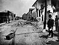
A damaged brick house on Tradd Street after the 1886 Charleston earthquake.
-
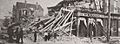
Charleston, SC after the 1886 earthquake.
