
List of former places of worship in Wealden facts for kids
In Wealden, a large area in East Sussex, England, there are 50 old churches, chapels, and other places of worship that are no longer used for religious services. Some of these buildings are now used for other things, while others are empty. This area is mostly countryside with five towns and many villages. Christian worship has a long history here, going back 1,200 years! For example, a Saxon leader started a church in Rotherfield way back in 790. By the 1800s, almost every village had at least one church.

Some churches stopped being used because fewer people lived nearby, or fewer people attended services. Sometimes, new churches were built, and the old ones were no longer needed. Many Protestant groups, called Nonconformists, were very popular in Sussex. They built many Baptist, Methodist, and Congregational chapels. Most of these buildings are still standing, but not all are still used as churches. Wealden also has over 130 places of worship that are still active today.
Many of these old church buildings in Wealden have a special protection called "listed status" from an organization called Historic England. A building gets "listed" when it's considered very important because of its history or how it was built. There are three levels of listed status:
- Grade I: These are buildings of "exceptional interest," meaning they are super important.
- Grade II*: These are "particularly important buildings" that are more than just special.
- Grade II: These are buildings of "special interest."
As of 2001, Wealden had 47 Grade I listed buildings, 106 Grade II* listed buildings, and 2,020 Grade II listed buildings.
Contents
- Wealden: A Look at the Area
- Old Places of Worship: What Happened to Them?
- Alfriston United Reformed Church
- Blackboys Methodist Church
- Boars Head Chapel
- Danehill Chapel
- Colkins Mill Free Church
- Cousley Wood Churches
- Cowbeech Preaching Station
- Trinity Hall, Crowborough
- Whitehill Citadel, Crowborough
- Zion Chapel, Danehill
- East Hoathly Chapels
- Forest Row Chapels
- Framfield Congregational Chapel
- Congregational Mission Hall, Golden Cross
- Hadlow Down Chapels
- Halland Mission Hall
- Hartfield Methodist Chapel
- Kingdom Hall, Hailsham
- St Peter's Church, Holtye Common
- Isfield Congregational Chapel
- Laughton Methodist Chapel
- Bethel Strict Baptist Chapel, Little London
- Wannock Baptist Chapel, Lower Willingdon
- Ebenezer Strict Baptist Chapel, Magham Down
- Maynard's Green Chapels
- Nazarene Particular Baptist Chapel, Ninfield
- St Laurence's Chapel, Polegate
- Rehoboth Chapel, Pell Green
- Holy Rood Church, Pevensey Bay
- Mount House Chapel, Piltdown
- Rotherfield Methodist Church
- St Peter, Prince of Apostles Church, Rotherfield
- Little St Mary's Church, Rushlake Green
- Russell's Green Wesleyan Methodist Chapel
- Shover's Green Baptist Chapel
- Salvation Army Hall, Sparrow's Green
- Turner's Green Gospel Hall
- Mount Hermon Baptist Chapel, Turner's Green
- Uckfield Baptist Church
- Uckfield Methodist Church
- Upper Dicker Methodist Chapel
- New Gospel Hall, Vines Cross
- Wadhurst Town Chapel
- Wadhurst Methodist Church
- Images for kids
- See also
Wealden: A Look at the Area

Wealden is the largest of the six local areas in East Sussex. It covers a huge area of about 83,317 hectares (that's over 200,000 acres!). East Sussex has three busy coastal towns (Brighton and Hove, Eastbourne, and Hastings) and a large countryside area. Wealden is right in the middle of this countryside.
In 2011, about 148,915 people lived in Wealden. About half of these people live in five small towns: Crowborough, Hailsham, Heathfield, Polegate, and Uckfield. Each of these towns has several places of worship for different Christian groups. The rest of the people live in many villages and tiny settlements called hamlets across the rural district. Many of these places have very old churches, where people have worshipped for over a thousand years! Early Christian leaders like St Wilfrid and St Cuthman helped bring Christianity to Sussex in the late 600s.
Old Places of Worship: What Happened to Them?
Many old churches and chapels in Wealden have been given new lives. Some have become homes, while others are now community centers or businesses. Here are a few examples of these interesting buildings:
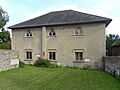
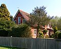
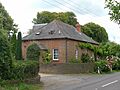
Alfriston United Reformed Church
.JPG)
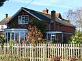
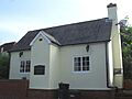
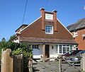
This church in Alfriston was built in 1801 as a Congregational chapel. It sits right on the village green by the River Cuckmere. Over the years, different groups used it. It closed in 2009 and is now a house. It is a Grade II listed building.
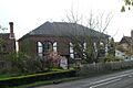
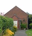
Blackboys Methodist Church
_(2).JPG)
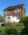
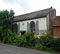
The Blackboys Methodist Church opened in 1883. The land for this church was given by the owner of a nearby manor. After being empty for a while, it was used for worship again in 1987. However, in 2006, it was given permission to be turned into a house, and it is no longer a church.
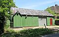
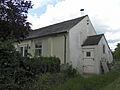
Boars Head Chapel

A small chapel was built in the 1800s for the Methodist community in Boarshead, near Crowborough. It was used for 106 years before it stopped being a church in 1967. Today, it is called the Chapel House Studio.
Danehill Chapel
,_Chelwood_Common.JPG)
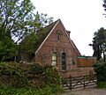
A group of Baptists met in this area as early as 1778. A mission hall was built in the 1880s. It was known as Danehill Chapel and Danehill Christian Fellowship. It was used for about 120 years. By 2015, it had been empty for nine years and was sold to become a home or business.
Colkins Mill Free Church

In the 1870s, a resident of Coggins Mill, a tiny hamlet near Mayfield, gave land for a wooden chapel. It was called Colkins Mill Gospel Hall. In 1984, the church members bought another chapel in Mayfield village. The old wooden chapel then became a house.
Cousley Wood Churches

Cousley Wood had two interesting former churches. One was built in 1864 as a school but also served as a church for many years. It closed in 1970 and became a house.

The other, founded in 1902, was known as the Monks Lane Mission. It was a "tin tabernacle" with blue corrugated iron walls. It offered services for different Christian groups. This building has also been changed and is now a house.
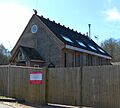
Cowbeech Preaching Station
This building was originally a cottage from the mid-1700s. A Baptist chapel was added to it in 1834. It stopped being used as a church around 1950 and is now one house. It is a Grade II listed building.
Trinity Hall, Crowborough
,_Crowborough.JPG)
A group of Baptists in Crowborough met in a house in the 1950s. They raised money to build a church nearby, which opened in the early 1960s. It was called Park Road Church and Trinity Hall. It even had a special tank for full-immersion baptisms! In 1994, it became the main office for a Christian charity.
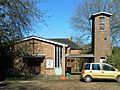
Whitehill Citadel, Crowborough
,_Whitehill_Road,_Crowborough_(March_2011)_(3).JPG)
This Salvation Army building in Crowborough was founded in 1908. It was still in use in the 1980s, but now it's a busy community center. It officially stopped being a place of worship in 2000.
Zion Chapel, Danehill

A Strict Baptist group started here in 1810. This chapel was built in 1815. It closed around 1967 and is now a house. It has a wooden porch on its red-brick front.
East Hoathly Chapels

In East Hoathly, a chapel called Providence Chapel was built in 1849. It was used by Independent Baptists and then Strict Baptists. The original building was taken down, and a house now stands on its site.

The East Hoathly Methodist Chapel was built in 1900–01. It was used for religious services until about 1941. This red-brick and stone building has a small spire.
Forest Row Chapels

The Strict Baptist community in Forest Row built a chapel in 1874. They moved to a larger building in 1928 and worshipped there until the early 2000s. In 2009, it was given permission to be turned into homes.
,_Forest_Row.JPG)
Our Lady of the Forest Church was a Roman Catholic church in Forest Row. It was visited by John F. Kennedy in 1963 when he was staying with Prime Minister Harold Macmillan. It closed on December 25, 2009, because there weren't enough priests.
Framfield Congregational Chapel

This chapel in Framfield was built in 1896. It was part of a group of chapels that joined together. The church stopped meeting around 1993, and the chapel is now a house.
Congregational Mission Hall, Golden Cross
,_Holmes_Hill,_Golden_Cross_(Derivative_of_Geograph_Image_2770172).jpg)
An old Congregational chapel near Golden Cross was replaced by another one nearby. This second building was still called a Mission Church in 1961, but it is now a house.
Hadlow Down Chapels
_(2).JPG)
Providence Chapel in Hadlow Down was 138 years old when a big storm in 1987 damaged it badly. This beautiful red and blue brick chapel has since been restored and is now a house. It is a Grade II listed building.
,_School_Road,_Hadlow_Down_(June_2015)_(1).JPG)
Another interesting chapel in Hadlow Down was called "the Tin Heaven." It was a tin tabernacle (a building made of corrugated iron) built in the late 1800s. It was moved closer to the village in 1907. It closed in 1940 and became a canteen, then a business.
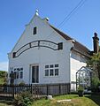
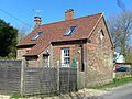
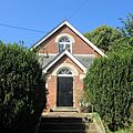
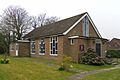
Halland Mission Hall

The Halland Mission Hall was built in 1886 because it was far from the main church in East Hoathly. It had a small spire and a bell tower. It closed in 1951 and was turned into a house.
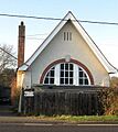
Hartfield Methodist Chapel

This old chapel on the High Street in Hartfield has been a home since 1968. It was built in 1857 to replace an even older wooden building. It's a brick and stone building with arched windows.
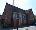
Kingdom Hall, Hailsham
.JPG)
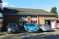
Jehovah's Witnesses in Hailsham built their first Kingdom Hall in 1970. A new Kingdom Hall replaced it in 1996. The old building now houses the East Sussex Federation of Women's Institutes.
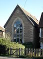
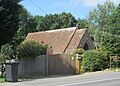
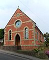
St Peter's Church, Holtye Common
.jpg)
A church was first built at Holtye Common in 1836, but it was replaced in 1892 by a small stone church with flying buttresses. It was declared no longer needed for worship in 2007.
Isfield Congregational Chapel

The Isfield Congregational Chapel in Isfield started around 1898. It was linked with chapels in Framfield and Uckfield. It closed in 1966 and was sold to become a house.
Laughton Methodist Chapel
This former chapel in Laughton was built around 1879. It also had a Sunday school and a minister's house. All of these buildings have now been turned into one house.
Bethel Strict Baptist Chapel, Little London

Now called Chapel House, this small brick chapel in Little London opened in 1879. It was used by different Baptist groups before closing exactly a century later, in 1979.
Wannock Baptist Chapel, Lower Willingdon

This chapel in Lower Willingdon was founded in a cottage in 1838 or 1839. A permanent chapel was built in 1851. It closed in 1972 and became a house.
Ebenezer Strict Baptist Chapel, Magham Down

This small chapel in Magham Down dates back to 1846. It was described as "possibly the smallest and simplest place of worship in Sussex." It closed in 1994 and was turned into a house.
Maynard's Green Chapels
_(1).JPG)
In Maynard's Green, a small chapel called St John's Chapel was built in 1863. It was made of stone and red brick. After it closed, it was turned into a house.
_(1).JPG)
Also in Maynard's Green, the New Gospel Hall was built in 1905. It was started by a group called Open Brethren. This building is also now a home. It closed in 1996 when a new chapel opened in nearby Horam.
Nazarene Particular Baptist Chapel, Ninfield

Built in 1831, this chapel in Ninfield was used by Independent Baptists and then Strict Baptists. It stopped being used for religious services around 1971 and was officially closed in 1994.
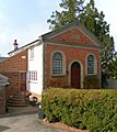
St Laurence's Chapel, Polegate
This chapel near Polegate is very old, with parts dating back to the 1300s! Worship has happened on this site since at least 1175. It was once a parish church. It is now on private land and is a Grade II* listed building, meaning it's very important.
Rehoboth Chapel, Pell Green

Rehoboth Chapel in Pell Green, near Wadhurst, was built in 1824. It was extended several times. This timber-framed chapel, with its wooden siding, was turned into a house in the 1980s. It is a Grade II listed building.
Holy Rood Church, Pevensey Bay

Services at this small Roman Catholic church in Pevensey Bay began in 1963. It was damaged by a storm in 1990. The church closed after its last service in October 2016.
Mount House Chapel, Piltdown
This red and blue brick building in Piltdown was a chapel from about 1860 until the late 1900s. It was used by the Church of Christ and then Baptists. It became a house in 1980.
Rotherfield Methodist Church
Methodists in Rotherfield met in houses until this red-brick chapel opened in 1879. It could hold 175 people but closed in the early 2000s.
St Peter, Prince of Apostles Church, Rotherfield
,_Rotherfield.JPG)
Rotherfield's Roman Catholic church was completed in 1963. It could hold 120 people. It closed for worship in 2019.
Little St Mary's Church, Rushlake Green
This church in Rushlake Green is now a village hall and community center. It was a short-lived place of worship.
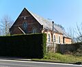
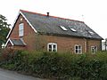
Russell's Green Wesleyan Methodist Chapel

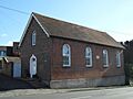
Wesleyan Methodists built this red-brick chapel in Russell's Green in 1832. It was extended later and is now a home.
Shover's Green Baptist Chapel
.jpg)
Shover's Green Baptist Chapel near Wadhurst was built in 1817 by Strict Baptists. This building, with its wooden siding and arched windows, closed around 1973 and became a house. It is a Grade II listed building.
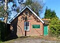
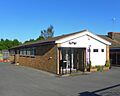
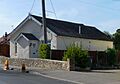
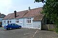
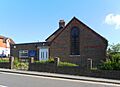
Salvation Army Hall, Sparrow's Green

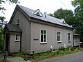
The Salvation Army in Wadhurst built a hall in Sparrow's Green in 1893. The group stopped meeting in 1975, and the hall was used for business. Another hall (pictured) was used for a time.
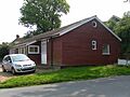
Turner's Green Gospel Hall

The first chapel here, made of corrugated iron, was built in 1941 but was destroyed by fire in 1970. A new building was opened soon after, but it closed in the early 1980s and was sold in 1987.
Mount Hermon Baptist Chapel, Turner's Green

This chapel in Turner's Green, Warbleton, was founded in 1865. It was a red-brick building with a porch. It was sold in the early 2000s and became a private wedding chapel.
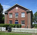
Uckfield Baptist Church

A Baptist chapel was started in Uckfield in 1788. The building you see now, which is a house, dates from 1874. The church is still active but meets at a school. This old chapel officially stopped being a church in 2005. It is a Grade II listed building.
Uckfield Methodist Church
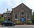
_(2).JPG)
This Methodist church in Uckfield was founded in 1897. In 2017, the church joined with Uckfield United Reformed Church to form a new church called Cornerstone Church. The old building is no longer used for worship.
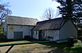
Upper Dicker Methodist Chapel

This chapel in Upper Dicker had a short life as a church. It stopped being used shortly after appearing on a map in 1843. It later became a school, a reading room, a community hall, a youth club, and then the headquarters of a cheese company!
New Gospel Hall, Vines Cross
_(1).JPG)
Opened in 1911, this chapel in Vines Cross had a large group of worshippers at first, but numbers slowly went down. It closed in the 1970s and was sold to become a house.
Wadhurst Town Chapel

Only a round window on the back wall of this building in Wadhurst shows that it was once a church. It was built as a Methodist chapel and later used by Baptists. It stopped being used for worship in 1935 and is now a greengrocer's shop.
Wadhurst Methodist Church

Built in 1874, this Methodist church on the High Street in Wadhurst has red and yellow brickwork. It replaced an older chapel from 1814. The church officially stopped being a place of worship in 2016 and was put up for sale to be turned into homes.
Images for kids
-
The former Alfriston United Reformed Church, now a home.
-
The former Blackboys Methodist Church.
-
The old Boars Head Chapel, now a studio.
-
The former Danehill Chapel.
-

The former Colkins Mill Free Church.
-
The former Cousley Wood National School and Mission Church.
-
The former Cousley Wood Free Church, a "tin tabernacle."
-
Trinity Hall, a former Baptist church in Crowborough.
-
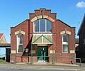
The former Salvation Army Citadel in Crowborough.
-
The former Zion Strict Baptist Chapel.
-
The site of the former Providence Chapel in East Hoathly.
-
The former Methodist Chapel in East Hoathly.
-
The former Providence Strict Baptist Chapel in Forest Row.
-
Our Lady of the Forest Church in Forest Row.
-
The former Framfield Congregational Chapel.
-
The former Congregational Mission Hall.
-
The restored Providence Chapel in Hadlow Down.
-
The "Tin Heaven" chapel in Hadlow Down.
-
The former Halland Mission Hall.
-
The former Hartfield Methodist Chapel.
-
The former Kingdom Hall in Hailsham.
-
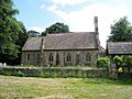
St Peter's Church at Holtye Common.
-
The former Isfield Congregational Chapel.
-
The former Bethel Chapel, now Chapel House.
-
The former Wannock Baptist Chapel.
-
The former Ebenezer Strict Baptist Chapel.
-
The former St John's Chapel.
-
The former New Gospel Hall.
-
The former Nazarene Particular Baptist Chapel.
-
The former Rehoboth Chapel.
-
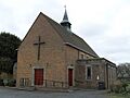
The Holy Rood Church in Pevensey Bay.
-
The former Methodist Chapel in Rotherfield.
-
St Peter, Prince of Apostles Church.
-
The former Wesleyan Methodist Chapel.
-
The former Shover's Green Baptist Chapel.
-
St George's Hall, formerly a Salvation Army Hall.
-
The former Gospel Hall in Turner's Green.
-
The former Mount Hermon Baptist Chapel.
-
The former Uckfield Baptist Church.
-
The former Uckfield Methodist Church.
-
The former Methodist Chapel in Upper Dicker.
-
The former New Gospel Hall in Vines Cross.
-
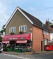
The former Wadhurst Town Chapel, now a shop.
-
The former Wadhurst Methodist Church.
See also
