
List of tallest buildings and structures in Glasgow facts for kids
.jpg)

Welcome to Glasgow, Scotland's biggest city! This article will tell you all about its tallest buildings and structures. Glasgow has many impressive tall buildings, from older apartment blocks built in the 1960s to modern offices and hotels.
The very tallest structure in Glasgow today is the Glasgow Tower. It stands at 127 metres (417 ft) (about 417 feet) tall and is part of the Glasgow Science Centre. But did you know that the tallest building ever in Glasgow was the Tait Tower? It was 91 m (299 ft) tall and built for a big exhibition in 1938, but it was taken down just one year later!
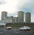
In the 1960s, Glasgow built many tall apartment buildings, called tower blocks. This was to help with a big housing shortage after the war. Glasgow became the first city in Britain with so many high-rise buildings. However, some of these buildings weren't built very well, and over time, many were taken down.
Later, in 1988, new tall buildings started to appear again, like the Crowne Plaza Hotel. Since the 1990s, developers have been planning and building new, fancy tall homes and offices, especially near the River Clyde. Some really tall skyscrapers were planned, but they didn't get built because of money problems.
Contents
Glasgow's Skyline: What's the Tallest?

It can be tricky to say exactly which building is the "tallest" in Glasgow, because it depends on how you measure!
- The Glasgow Tower is the tallest free-standing structure in Glasgow, and in all of Scotland! It's 127 m (417 ft) tall, but this measurement includes its pointy top, called a spire. This amazing tower even holds a Guinness World Record because the whole building can spin around 360 degrees!
- After some very tall apartment blocks were taken down in 2015, the two western tower blocks of the Balgrayhill estate in Springburn are now the tallest apartment buildings still standing in Glasgow.
Glasgow's Tallest Buildings and Structures
Here's a list of some of the tallest buildings and structures that are already built in Glasgow.
Tallest Buildings You Can See Today
| Rank | Name | Image | Height | Floors | Year Built | Main Use | Fun Facts |
|---|---|---|---|---|---|---|---|
| 1 | Glasgow Tower |  |
127 m (417 ft) | 2 | 2001 | Viewing Platform | Holds a Guinness World Record for being the tallest tower in the world that can rotate all the way around! |
| 2 | Glasgow University Tower |  |
85 m (279 ft) | ? | 1887 | University | A very old and grand university building. |
| 3= | 22 Viewpoint Place |  |
78 m (256 ft) | 26 | 1964 | Homes | Located in Springburn. |
| 3= | 42 Viewpoint Place | |
78 m (256 ft) | 26 | 1964 | Homes | Located in Springburn. |
| 3= | 120 Wyndford Road | .jpg) |
78 m (256 ft) | 26 | 1964 | Homes | Located in Wyndford. |
| 3= | 151 Wyndford Road | .jpg) |
78 m (256 ft) | 26 | 1964 | Homes | Located in Wyndford. |
| 3= | 171 Wyndford Road | .jpg) |
78 m (256 ft) | 26 | 1964 | Homes | Located in Wyndford. |
| 3= | 190 Wyndford Road | |
78 m (256 ft) | 26 | 1964 | Homes | Located in Wyndford. |
| 3= | 15 Croftbank Street |  |
78 m (256 ft) | 26 | 1964 | Homes | Located in Springburn. |
| 3= | 250 Edgefauld Road | |
78 m (256 ft) | 26 | 1964 | Homes | Located in Springburn. |
| 11= | 2 Taylor Place |  |
75 m (246 ft) | 25 | 1967 | Homes | Located in Townhead. |
| 11= | 15 Grafton Place |  |
75 m (246 ft) | 25 | 1967 | Homes | Located in Townhead. |
| 11= | 12 Dobbie's Loan Place | .jpg) |
75 m (246 ft) | 25 | 1967 | Homes | Located in Townhead. |
| 11= | 7 St. Mungo Place |  |
75 m (246 ft) | 25 | 1967 | Homes | Located in Townhead. |
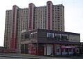
| 11= | 178 Balgrayhill Road |  |
75 m (246 ft) | 25 | 1964 | Homes | This is one of the highest points built by people in Glasgow. Located in Springburn. |
| 11= | 198 Balgrayhill Road | |
75 m (246 ft) | 25 | 1964 | Homes | This is one of the highest points built by people in Glasgow. Located in Springburn. |
| 17 | Glasgow City Chambers |  |
73 m (240 ft) | 4 | 1889 | Government Building | Where the city's government works. |
| 18 | St. Andrew House | .jpg) |
71 m (233 ft) | 18 | 1964 | Hotel | It became a Premier Inn hotel in 2012. The rooms on the 18th floor are the highest hotel rooms in Glasgow! |
| 19 | Hilton Glasgow |  |
70 m (230 ft) | 20 | 1992 | Hotel | A well-known hotel in the city. |
| 20= | There are ten other apartment blocks from the 1960s and one modern apartment block that are all the same height. | 69 m (226 ft) | 24 | Various | Homes | These are found in areas like Hutchesontown, Cowcaddens, Knightswood, and Glasgow Harbour. | |
| 21 | Anniesland Court |  |
66 m (217 ft) | 24 | 1968 | Homes | This is the tallest building in Scotland that is officially protected as a historic building. It's the only apartment block in Glasgow with a special 'Category A' listing. Located in Anniesland. |
| 22= | Cineworld Glasgow |  |
62 m (203 ft) | 16 | 2001 | Cinema | This is the tallest cinema complex in the whole world! |
| 22= | Argyle Building |  |
62 m (203 ft) | 20 | 2008 | Homes | A modern apartment building. |
| 22= | Bridle Works Building |  |
62 m (203 ft) | 20 | 2021 | Student Homes | Provides housing for students. |
| 25 | Queen Elizabeth University Hospital | .jpg) |
60 m (200 ft) | 14 | 2015 | Hospital | A large hospital in the city. |
| 26 | Block H2 – Central Quay |  |
58 m (190 ft) | 20 | 2022 | Homes and Shops | Part of a new development called Central Quay. |
| 27 | Crowne Plaza Glasgow |  |
55 m (180 ft) | 17 | 1989 | Hotel | Part of the SECC area. |
| 28 | Buchanan Wharf towers | .jpg) |
54 m (177 ft) | 19 | 2023 | Mixed Use | These buildings are part of the Buchanan Wharf complex. |
| 29 | Elmbank Gardens |  |
53 m (174 ft) | 15 | 1973 | Hotel | It used to be an office building, but it was turned into a hotel in 1995. |
| 30 | Livingstone Tower |  |
52 m (171 ft) | 17 | 1965 | University | This building is part of the University of Strathclyde. |
| 31 | 1 Atlantic Square |  |
45 m (148 ft) | 10 | 2022 | Office | Located in the city's financial area. |
Other Notable Tall Structures
Here are some other tall structures in Glasgow that are not buildings, but are still very impressive!
| Name | Image | Height | Year Built | Main Use | Fun Facts |
|---|---|---|---|---|---|
| Cathkin Braes wind turbine | .jpg) |
125 m (410 ft) 80 m (260 ft) |
2013 | Wind turbine | This turbine helps make clean energy. |
| Glasgow Cathedral |  |
68.6 m (225 ft) | 1197 | Cathedral | A very old and beautiful church. |
| St Andrew's West Church | .jpg) |
67 m (220 ft) | 1852 | Church | Another historic church in Glasgow. |
| St Columba Church |  |
61 m (200 ft) | 1904 | Cathedral | A tall church building. |
| St Mary's Cathedral |  |
60.5 m (198 ft) | 1893 | Cathedral | A grand cathedral. |
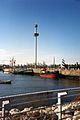
| Finnieston Crane |  |
53 m (174 ft) | 1931 | Cantilever crane | A famous landmark that used to lift heavy cargo at the docks. |
Buildings That Are No Longer Here
Glasgow has also seen some very tall buildings and structures that have since been taken down.
| Name | Image | Height | Year Built | Year Demolished | Fun Facts | |
|---|---|---|---|---|---|---|
| Townsend Chimney |  |
138 m (453 ft) | 1859 | 1928 | This was the tallest chimney in the world from 1859 to 1889! | |
| Tennant's Stalk | _(cropped).jpg) |
133 m (436 ft) | 1842 | 1922 | This was the tallest chimney in the world before the Townsend Chimney. It was taken down after being hit by lightning! | |
| Pinkston Power Station cooling tower | .jpg) |
94 m (308 ft) | 1952 | 1976 | When it was built, this was the largest cooling tower in Europe! | |
| Tait Tower |  |
91.4 m (300 ft) | 1938 | 1939 | Built for the 1938 Empire Exhibition, but only stood for one year. | |
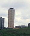
| 109 Bluevale Street | .jpg) |
90.8 m (298 ft) | 1968 | 2015 | This was one of the tallest apartment buildings in Scotland. | |
| 51 Whitevale Street |  |
90.8 m (298 ft) | 1968 | 2015 | Also one of the tallest apartment buildings in Scotland. | |
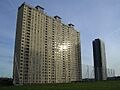
| 10 Red Road Court |  |
89 m (292 ft) | 1967 | 2015 | At the time they were built, these were some of the tallest apartment buildings in Europe! | |
| 33 Petershill Drive | |
89 m (292 ft) | 1967 | 2015 | Another one of the Red Road Flats. | |
| 63 Petershill Drive |  |
89 m (292 ft) | 1967 | 2015 | Part of the famous Red Road Flats. | |
| 93 Petershill Drive | |
89 m (292 ft) | 1967 | 2015 | One of the Red Road Flats. | |
| 123 Petershill Drive | |
89 m (292 ft) | 1967 | 2015 | The last of the tallest Red Road Flats. | |
| 21 Birnie Court | _(cropped).jpg) |
89 m (292 ft) | 1967 | 2013 | Another one of the Red Road Flats. | |
| 153-213 Petershill Court |  |
78 m (256 ft) | 1967 | 2012 | A slightly shorter Red Road Flat. | |
| 10-30 Petershill Court |  |
74 m (243 ft) | 1967 | 2015 | Another Red Road Flat. | |
| Clydesdale Bank Tower | |
73 m (240 ft) | 1987 | 1989 | Built for the Glasgow Garden Festival, then moved to Wales! | |
| 240 Roystonhill | |
72 m (236 ft) | 1967 | 1992 | Located in Royston. | |
| 20 Rosemount Street | |
72 m (236 ft) | 1967 | 2013 | Located in Royston. | |
| 40 Rosemount Street | |
72 m (236 ft) | 1967 | 2016 | Located in Royston. | |
| Ten other apartment blocks from the 1960s were also taken down. | 69 m (226 ft) | 24 | Various | Homes | These were in areas like Laurieston, Gorbals, and Hutchesontown. |
Images for kids
-
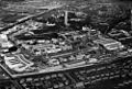
The Tait Tower, built for the 1938 Empire Exhibition.
-
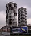
109 Bluevale Street, one of the Bluevale and Whitevale Towers.
-
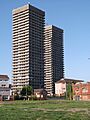
51 Whitevale Street, another of the Bluevale and Whitevale Towers.
-

Some of the Red Road Flats.
-
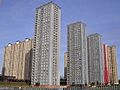
More of the Red Road Flats.
-
21 Birnie Court, one of the Red Road Flats.
-
153-213 Petershill Court, a Red Road Flat.
-
10-30 Petershill Court, another Red Road Flat.
-
The Clydesdale Bank Tower at the Glasgow Garden Festival.
-
240 Roystonhill, an apartment block that was demolished.
-
20 and 40 Rosemount Street, two more demolished apartment blocks.
See also
- Glasgow tower blocks
- List of tallest buildings and structures in Edinburgh
- List of tallest buildings and structures in Scotland
