
Little Temple facts for kids
Quick facts for kids Little Temple |
|
|---|---|

Little Temple (right) seen with Mount Temple
|
|
| Highest point | |
| Elevation | 2,653 m (8,704 ft) |
| Prominence | 233 m (764 ft) |
| Listing | Mountains of Alberta |
| Geography | |

Little Temple
Location in Alberta

Little Temple
Location in Canada
|
|
| Location | Banff National Park Alberta, Canada |
| Parent range | Bow Range Canadian Rockies |
| Topo map | NTS 82N/08 |
| Climbing | |
| Easiest route | Scramble |
Little Temple is a mountain in Banff National Park in Alberta, Canada. It stands about 2,653 meters (8,704 feet) tall. You can find Little Temple in the Bow River Valley. It's located between Paradise Creek and Moraine Creek, about 6 kilometers (3.7 miles) south of Lake Louise, Alberta. You can see this mountain from the Icefields Parkway. It's often seen with its taller neighbor, Mount Temple, which is just over 1 kilometer (0.66 miles) away to the southwest.
How Little Temple Was Formed (Geology)
Just like other mountains in Banff Park, Little Temple is made of sedimentary rock. This type of rock forms from layers of sand, mud, and tiny bits of sea creatures that settle over millions of years. These layers were laid down during the Precambrian to Jurassic periods, which are very long stretches of time in Earth's history.
These rocks formed in shallow seas that once covered this area. Later, during an event called the Laramide orogeny, powerful forces pushed these rock layers eastward. This movement caused the rocks to fold and break, lifting them up to create the mountains we see today.
Weather and Climate Around Little Temple
Little Temple is located in a subarctic climate zone. This means it has very cold, snowy winters. Temperatures can drop below -20 °C (-4 °F). With the wind chill, it can feel even colder, sometimes below -30 °C (-22 °F).
Summers in this area are usually mild. The snow and ice that melt from Little Temple drain into the Bow River. The Bow River is an important waterway that eventually flows into the Saskatchewan River.
Gallery
-
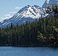
Little Temple from Herbert Lake
-
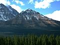
Little Temple
-
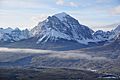
Little Temple in front of Mount Temple


