Loch Morar facts for kids
Quick facts for kids Loch Morar |
|
|---|---|
The shallower western end of the loch
|
|
| Location | NM76129087 |
| Coordinates | 56°57′00″N 5°40′20″W / 56.95000°N 5.67222°W |
| Type | freshwater loch, dimictic, oligotrophic |
| Primary inflows | River Meoble |
| Primary outflows | River Morar |
| Catchment area | 168 square kilometres (65 sq mi) |
| Basin countries | Scotland |
| Max. length | 18.8 km (11.7 mi) |
| Max. width | 2.35 km (1.46 mi) |
| Surface area | 26.7 km2 (10.3 sq mi) |
| Average depth | 87 metres (284 ft) |
| Max. depth | 310 m (1,017 ft) |
| Water volume | 2.3073 cubic kilometres (81,482,000,000 cu ft) |
| Shore length1 | 59 km (37 mi) |
| Surface elevation | 14 metres (46 ft) |
| 1 Shore length is not a well-defined measure. | |
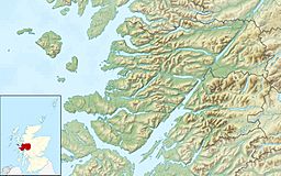
Loch Morar (which means "Loch of the Big Water" in Gaelic) is a large freshwater loch (a lake) in the Highland area of Scotland. It is the fifth-largest loch in Scotland by how much space it covers. It is also the deepest freshwater body in the British Isles. This means it's deeper than any other lake in the UK and Ireland!
The loch was formed by glaciers about 10,000 years ago. Its surface is about 9 meters (30 feet) above sea level. Loch Morar separates the area called North Morar from Arisaig and Moidart.
Contents
About Loch Morar
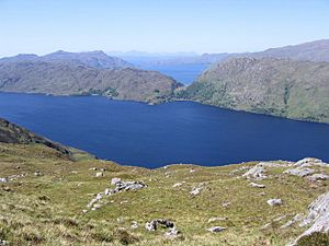
Loch Morar is about 18.8 kilometers (11.7 miles) long. It covers an area of 26.7 square kilometers (10.3 square miles). Its deepest point is an amazing 310 meters (1,017 feet) deep!
Scientists studied Scottish lochs in 1910. They found Loch Morar to have an average depth of 86.5 meters (284 feet). Its total water volume is huge, about 2.3 cubic kilometers (81.5 billion cubic feet).
The water in Loch Morar is very clear. It has very few nutrients, which means it's a special place for nature. Because of this, it is a Site of Special Scientific Interest (SSSI).
Water Flow and Surroundings
The main river flowing into Loch Morar is the River Meoble. This river comes from Loch Beoraid on the south side. There are also three other big rivers that flow into the eastern end of the loch.
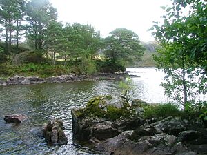
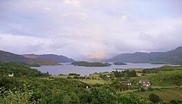
The water flows out of Loch Morar through the River Morar. This river is at the western end of the loch. It is only a few hundred meters long, making it one of the shortest rivers in the British Isles! At the shallower western end, there are several islands covered with trees.
The village of Morar is located at the western end of the loch. It sits between Arisaig and Mallaig on the main coastal road. Other small villages like Bracorina and Bracara are found along the northern shore. However, there is no road along the southern shore.
Loch Morar's Legends
Loch Morar has some interesting old stories. According to an old dictionary of the Scottish Gaelic language, people believed the loch was blessed. They called it "St. Columba's Well." It was said that its water was safe to drink, even when you were hot. It also supposedly never froze.
There's a story of a young woman who lost her hair. It grew back after she washed her head in the loch. This shows how special people thought the loch's water was.
Just like Loch Ness, people sometimes report seeing large, unknown creatures in Loch Morar. This mysterious creature has been nicknamed Mòrag.
A Glimpse into History
There's an island in Loch Morar called Eilean Bàn, which means "White Island." Long ago, local people used this island to graze their cattle. It used to be bare, but in the 1800s, trees were planted there. Now it's covered in thick woods.
This island was once a secret place for Catholic education. After the Jacobite rising of 1715, a small school was set up there. It was a hidden place for training priests. Even after the school moved, Eilean Bàn remained a secret meeting place. It was used by religious leaders and had a hidden library.
The Search for Leaders
After the Battle of Culloden in 1746, British forces searched for Jacobite leaders. These leaders were people who supported Prince Charles Edward Stuart. On June 8, 1746, soldiers and sailors traveled a difficult nine miles to Loch Morar. They believed important Jacobite leaders were meeting on Eilean Bàn.
When the soldiers arrived, they saw people on the island. The people on the island even fired at the soldiers! But then, the King's ships brought their boats overland to the loch. The people on the island quickly lost courage.
The leaders managed to escape from Eilean Bàn by boat. They hid in the mountains. When the government soldiers reached the island, they found the hidden house and chapel. The sailors quickly took things from the chapel and damaged the building. Many books and papers were lost or destroyed.
Some of the old foundation stones of the chapel and school can still be seen on Eilean Bàn today. It was a big loss for the history of the Catholic Church in Scotland.
Hidden Treasures and Captures
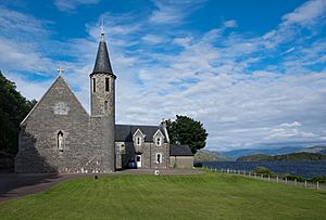
However, some items from the chapel were saved. In 1917, a historian wrote about green church clothes from 1745. These clothes, along with an old silver cup, are kept at the Morar chapel-house. It's thought they were part of the island chapel's items and were saved from being destroyed.
After the events on Eilean Bàn, the soldiers continued their search. They suspected that a Jacobite leader named Simon Fraser, 11th Lord Lovat was hiding nearby. They searched caves around the loch for three days. They eventually found and captured Lord Lovat hiding in a cave in Glen Meoble.
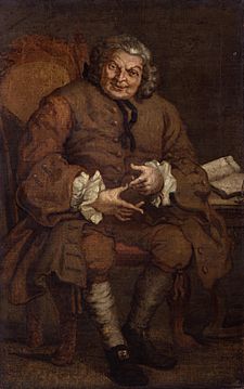
Lord Lovat's capture was a big deal in London. People were very happy, almost as if Prince Charles Edward Stuart himself had been caught. Many stories grew about how he was captured.
Bishop MacDonald, who had escaped from Eilean Bàn, stayed hidden locally. He eventually escaped to France on September 19, 1746. This happened during the sixth attempt by French ships to rescue the Prince and his group.
Changes Over Time
During a time known as the Highland Clearances, many people living around Loch Morar moved away. They emigrated to Canada. Boats left in 1790, 1802, and 1826, carrying people to places like Quebec, Glengarry in Ontario, and Nova Scotia.
During the Second World War, a building called Swordland Lodge on the northern shore of the loch was used. It was a secret training school for the Special Operations Executive, a special British spy group.
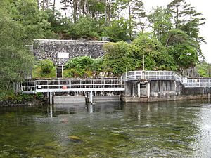
A hydroelectric power station was built on the River Morar. It started working in 1948. This station uses the power of water to create electricity.
Loch Morar's Geology
Loch Morar sits in an area made of very old rocks. These rocks were formed a long, long time ago, during the Cambrian period. The loch itself fills a deep basin. This basin was carved out by glaciers moving along a fault line (a crack in the Earth's crust).
The deep part of the loch was created over many thousands of years by glaciers. These glaciers moved back and forth during the last million years. At the western end of the loch, there's a fan-shaped area of sand and gravel. This shows where the glaciers stopped. These deposits blocked the loch's old outflow, making it drain from a different corner.
The area that collects water for the loch is about 168 square kilometers (65 square miles). The rocks in this area don't have many nutrients.
Wildlife in and Around the Loch
The area around Loch Morar has different types of nature. There are natural woodlands, open hillsides, and areas where sheep and cattle graze. There are also planted forests with different kinds of trees. Only a small part of the loch's surface can support plants growing in the water.
Fish Life
Loch Morar is home to several types of fish. These include Atlantic Salmon, brown trout and sea trout, Arctic char, eels, sticklebacks, and minnows. Trout caught here usually weigh about 340 grams (3/4 pound). However, much larger "ferox trout" have been caught, weighing up to 6.8 kilograms (15 pounds)!
The number of salmon and sea trout caught in the loch went down a lot between the 1970s and 1980s. This was a common problem on the west coast of Scotland. The practice of adding young salmon and sea trout to the River Morar was stopped in 2007.
The main places where salmon and trout lay their eggs are the River Meoble and other smaller streams that flow into the loch. The hydroelectric power station on the River Morar is turned off when young fish are moving out to sea. This helps protect them.
The fishing in the area is managed by a special group. They have a full-time manager to look after the fish. Sometimes, people try to catch fish illegally with nets at the mouth of the River Morar.
See also
 In Spanish: Lago Morar para niños
 | James Van Der Zee |
 | Alma Thomas |
 | Ellis Wilson |
 | Margaret Taylor-Burroughs |


