
Lockatong Formation facts for kids
Quick facts for kids Lockatong FormationStratigraphic range: Norian, 221.5–205.6Ma |
|
|---|---|
| Type | Geological formation |
| Unit of | Newark Supergroup |
| Sub-units | Walls Island Member (in part), Tumble Falls Member, Smith Corner Member, Prahls Island Member, Tohickon Member, Skunk Hollow Member, Byram Member, Ewing Creek Member, Nursery Member, Princeton Member, Scudders Falls Member, Wilburtha Member |
| Underlies | Passaic Formation |
| Overlies | Stockton Formation |
| Lithology | |
| Primary | Mudstone |
| Other | Sandstone, conglomerate |
| Location | |
| Region | Pennsylvania, New Jersey, New York |
| Country | |
| Type section | |
| Named for | Lockatong Creek |
The Triassic Lockatong Formation is a special type of rock layer found in Pennsylvania, New Jersey, and New York. It gets its name from the Lockatong Creek in Hunterdon County, New Jersey. This rock formation helps scientists learn about what the Earth was like millions of years ago.
Contents
What is the Lockatong Formation?
The Lockatong Formation is mostly made of light to dark gray, greenish-gray, and black rocks. These rocks are very fine-grained sandstone, silty argillite (a type of hard mudstone), and laminated mudstone. "Laminated" means the rock has many thin layers, like pages in a book. In New Jersey, these rock layers show a repeating pattern. Sometimes, you can find hornfels, which are hard rocks formed by heat from nearby diabase and basalt (volcanic rock) flows.
How it Formed
Scientists believe the Lockatong Formation was created from sediments in ancient lakes or along their shores. The way these sediments mix with those from the nearby Stockton Formation and Passaic Formation suggests that the lake environments changed over time. This could be due to changes in climate or the shifting land. The presence of calcite (a mineral found in limestone) in the sediments tells us that the climate was often very dry, with high rates of evaporation.
Ancient Life (Paleobiota)
The Lockatong Formation is famous for its fossils! The most common fossils found here are invertebrate burrows, which are traces left by ancient worms or other creatures. But scientists have also found fossils of fish and even some land animals.
Ancient Land Animals (Tetrapods)
Many interesting land animals, called tetrapods, lived when the Lockatong Formation was forming. Here are some of them:
| Tetrapods of the Lockatong Formation | |||||
|---|---|---|---|---|---|
| Genus | Species | Where Found | What Was Found | Notes | |
|
Eupelor |
E. durus |
Phoenixville? |
Shoulder bones |
A questionable amphibian, possibly related to metoposaurids. |
|
|
Gwyneddosaurus |
G. erici |
Gwynedd |
Part of a skeleton |
A questionable reptile. It might be a mix of different fossils, like fish and Tanytrachelos. |
|
| Hypuronector | H. limnaios | Granton Quarry, Weehawken Quarry, Edgewater Quarry | Several partial skeletons | A drepanosaur, known for its deep tail, suggesting it was a swimmer. | |
| Icarosaurus | I. siefkeri | Granton Quarry | A partial skeleton | A kuehneosaurid, a type of gliding reptile. | |
|
Rhabdopelix |
R. longispinis |
Gwynedd |
Lost bones |
A questionable reptile, possibly a mix of Tanytrachelos, Icarosaurus, or fish fossils. |
|
| Rutiodon | R. carolinensis | Granton Quarry, Princeton, Phoenixville | Skull, teeth, other pieces | A phytosaur, an ancient reptile that looked a bit like a crocodile. | |
| Tanytrachelos | T. ahynis | Granton Quarry, Haines & Kibblehouse Quarry, Weehawken Quarry, other places | Many partial skeletons | A small and common tanystropheid, a reptile with a very long neck. | |
Ancient Fish
The lakes of the Lockatong Formation were home to many types of fish.
| Fish of the Lockatong Formation | |||||
|---|---|---|---|---|---|
| Genus | Species | Where Found | What Was Found | Notes | |
| Carinacanthus | C. jepseni | Gwynedd | A partial skeleton | A very rare hybodont shark. | |
| Cionichthys | C. sp. | Gwynedd, Weehawken Quarry | Partial skeletons | A rare redfieldiid fish. | |
|
Diplurus |
D. longicaudatus | Granton Quarry, Gwynedd, Princeton | Part of a skull and scales | A rare coelacanth, a type of fish thought to be extinct until rediscovered. | |
| D. newarki | Granton Quarry, Gwynedd, Princeton, Weehawken Quarry, Arcola. | Many skeletons | A very common coelacanth. | ||
|
Lysorocephalus |
L. gwynnedensis |
Gwynedd |
Part of a skull |
A questionable fish, likely the same as Turseodus. |
|
| Pariostegus? | P. sp. | Arcola, Granton Quarry | Isolated fossils | A rare but very large coelacanth. | |
|
Rabdiolepis |
R. gwyneddensis |
Gwynedd |
A partial skeleton |
A questionable coelacanth. |
|
| Semionotus | "S. brauni group" | Weehawken Quarry, Arcola. | Many skeletons | A common fish in this area. | |
| Synorichthys | S. cf. S. stewarti | Granton Quarry, Weehawken Quarry, Arcola. | Many skeletons | A common redfieldiid fish. | |
| Turseodus | T. acutus | Granton Quarry, Princeton, Phoenixville, Weehawken Quarry, Arcola, Gwynedd, Miller's Quarry, Haines & Kibblehouse Quarry. | Many skeletons | A very common fish that might include several different species. | |
Trace Fossils (Ichnofossils)
Besides bones, scientists also find "trace fossils" in the Lockatong Formation. These are signs of ancient life, like footprints or burrows.
| Ichnofossils of the Lockatong Formation | |||
|---|---|---|---|
| Ichnogenus | Ichnospecies | Where Found | Notes |
| Anchisauripus | A. gwyneddensis | Gwynedd | Possibly the same as Atreipus milfordensis. |
| Apatopus | A. lineatus | Schuylkill outcrops | Tracks made by phytosaurs. |
| Atreipus | A. milfordensis | Souderton, Gwynedd, Arcola, Schuylkill outcrops? | Tracks from four-legged ornithischian dinosaurs or similar creatures. |
| Brachychirotherium | B. parvum | Arcola, Schuylkill outcrops | Possibly tracks from aetosaurs (armored reptiles). |
| Grallator | G. sp. | Tracks from theropod dinosaurs (two-legged meat-eaters). | |
|
Gwyneddichnium |
G. majore |
Gwynedd, Souderton, many other places. | Tracks from small tanystropheids like Tanytrachelos. |
| G. minore | Gwynedd | A questionable name; might be the same as G. majore. | |
| G. elongatum | Gwynedd | A questionable name; might be the same as G. majore. | |
| Platypterna | P. lockatong | Gwynedd | Questionable ornithischian tracks. |
|
Rhynchosauroides |
R. brunswickii | Arcola? Gwynedd? | Tracks from Sphenodontians (like modern tuataras) or lizards. |
| R. hyperbates | Arcola, Schuylkill outcrops. | Tracks from Sphenodontians or lizards. | |
| R. sp. | Souderton, Phoenixville. | Uncertain Rhynchosauroides tracks. | |
Types of Rock (Geological Facies)
The Lockatong Formation has different types of mudstone, each telling a story about the ancient lakes where they formed.
Laminated Mudstone
This type of mudstone is gray to black and has very thin, flat layers. It formed in deep, calm lakes that lasted a long time. Some layers are "graded," meaning the sediment settles out from heaviest to lightest after a sudden flow of water. Other layers have a "pinch-and-swell" shape, showing that waves moved the sediment around.
The thinnest, flattest layers formed in the deepest parts of the largest lakes. These layers are very thin bands of dark, organic material alternating with limestone or clay. They might have formed due to seasonal changes. The lack of waves or burrowing animals means these deep lake bottoms had very little oxygen. This is why well-preserved fish skeletons are often found here. Scientists think these deep lakes were at least 60 to 100 meters deep.
Thin-bedded Mudstone
These mudstones are red to gray and have layers that are thicker than laminated mudstone but thinner than massive mudstone. They formed in shallower parts of the lakes or along the lakeshores. The "graded" and "pinch-and-swell" layers here show that these areas were affected by floods or strong waves during storms.
Some thin-bedded mudstones are full of burrows, making them look "shredded." This means many animals lived and moved through the mud. Because the water was shallower and more active, the sediments are coarser. These mudstones often have layers of siltstone or sandstone mixed in. You might even see ripple marks or other patterns from water movement.
When the lake mud dried out often, deep mudcracks formed. These cracks could be simple lines or complex, branching patterns. When floods came, the cracks filled with new mud. Sometimes, tiny air bubbles, called vesicles, are preserved in these refilled cracks.
Massive Mudstone
Red to gray massive mudstone has no clear layers. This type of mudstone almost always has mudcracks, meaning the area was dry most of the time. "Brecciated" massive mudstone is heavily cracked in many directions, looking like a patchwork of mud pieces held together by other minerals. This formed on dry lakebeds, called playas, that repeatedly got wet and dried out.
Another type is "peloidal" massive mudstone, where the mud fragments are small, rounded clumps. This looks like modern salty playas, where salt makes the mud crumbly. The wettest massive mudstone is "burrowed" massive mudstone, which was originally thin-bedded but became completely mixed up by burrowing animals.
Age of the Formation
The Lockatong Formation is from the Upper Triassic period. It was laid down between 237 and 207 million years ago. It sits below many other rock formations of the Atlantic coastal plain. It also mixes with the Stockton Formation and Passaic Formation. There are also places where hot, molten rock (like diabase and basalt) pushed into the Stockton Formation, creating metamorphic rocks (rocks changed by heat and pressure).
Images for kids
-
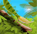
Hypuronector, an ancient swimming reptile.
-
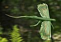
Icarosaurus, a gliding reptile.
-
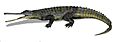
Rutiodon, a crocodile-like phytosaur.


