Lonesome Valley facts for kids
Quick facts for kids Lonesome Valley |
|
|---|---|
 |
|
| Length | 23 mi (37 km) NNW x SSE |
| Geography | |
| Country | United States |
| State | Arizona |
| County | Yavapai |
| Communities | Chino Valley, Prescott Valley and Paulden |
| Borders on |
List
|
| River | Granite Creek |
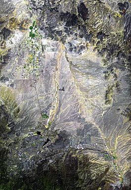
Lonesome Valley is a long valley in central Yavapai County, Arizona. It stretches for about 23 miles (37 kilometers). This valley extends southeast from Chino Valley (Arizona).
The Verde River starts near Paulden, Arizona, which is at the northwest end of Lonesome Valley. A smaller valley, called Little Chino Valley, connects Chino Valley to Lonesome Valley. It acts as a link between the two areas.
Important natural features surround the valley. To the west and southwest, you'll find Granite Mountain. The unique rock formations of Granite Dells are also nearby. The Black Hills (Yavapai County) form the eastern edge of Lonesome Valley.
At the southern end of the valley, near Prescott Valley, Arizona, there's a special area called a water divide. This divide separates the water that flows into the Verde River from the water that flows into the Agua Fria River. Both of these rivers eventually join the Gila River in central Arizona.
Contents
Exploring Lonesome Valley
Lonesome Valley generally runs from the north-northwest to the south-southeast. It has a unique shape in the middle, like an upside-down "V". This shape is created by two water channels.
One channel is Granite Creek, which flows on the west side. The other is an unnamed stream on the east. Both of these streams flow north and eventually meet the Verde River.
At the southern part of Lonesome Valley, another unnamed stream flows south from the water divide. This stream joins the Agua Fria River.
Landforms and Features
Lonesome Valley looks somewhat round, but the town of Chino Valley is on a flat area in the northwest. On the eastern side, near the Black Hills, you can see "alluvial fans." These are fan-shaped deposits of sand and gravel left by flowing water.
To the west and southwest, the Granite Mountain (Arizona) area has a large section of these deposits too. The southwest edge of Lonesome Valley is next to the northern part of Granite Dells. This is where Granite Creek flows out to the north.
Watson Lake is located just south of the Granite Dells. Granite Creek flows into this lake. The highest point in the valley is Black Hill, which stands at about 5,030 feet (1,533 meters). It's located on the east side of Granite Creek, in the central-southwest part of the valley.
Getting Around Lonesome Valley
Several roads help you explore Lonesome Valley. Arizona State Route 89 runs along the western side of the valley. If you're coming from Prescott, this route takes you past Watson Lake. Then it goes through the Granite Dells and continues to Chino Valley, Arizona.
Route 89 then goes to Paulden, Arizona, which is at the northwest edge of Lonesome Valley. Near Paulden, you'll find Sullivan Lake, a small reservoir on the Verde River.
Arizona State Route 89A branches off from Route 89 at Granite Dells. It heads east and northeast towards the Black Hills. This route is how you get to Jerome, a historic town on the eastern side of the mountains. Route 89A is also near the southern end of Lonesome Valley, close to the water divide north of Prescott Valley.
The Agua Fria River is to the south. Lynx Creek flows north from the Bradshaw Mountains, then turns east to join the Agua Fria. Other streams also flow south from the water divide into the Agua Fria.
Arizona State Route 69 goes through Prescott Valley. This route gives you access to the southern parts of Lonesome Valley, including Glassford Hill to the west, and areas on the western side of the Black Hills to the northeast.
Another road, Perkinsville Road, starts in Chino Valley, Arizona. It goes east from Route 89 into the middle of Lonesome Valley. Then it turns north through the northern part of the valley and Little Black Mesa. This road leads to Perkinsville, Arizona on the Verde River. From Perkinsville, you can continue north to Williams, which is about 30 miles (48 kilometers) away.
Images for kids
See also
 In Spanish: Prescott Valley (Arizona) para niños
 | Anna J. Cooper |
 | Mary McLeod Bethune |
 | Lillie Mae Bradford |


