Longlands facts for kids
Quick facts for kids Longlands |
|
|---|---|
| Population | 10,442 (2011 Census. Ward) |
| OS grid reference | TQ449722 |
| London borough | |
| Ceremonial county | Greater London |
| Region | |
| Country | England |
| Sovereign state | United Kingdom |
| Post town | SIDCUP |
| Postcode district | DA14, DA15 |
| Post town | LONDON |
| Postcode district | SE9 |
| Dialling code | 020 |
| Police | Metropolitan |
| Fire | London |
| Ambulance | London |
| EU Parliament | London |
| UK Parliament |
|
| London Assembly |
|

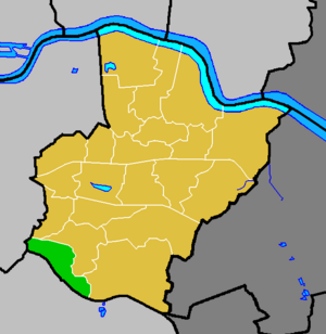
Longlands is a part of South East London. It sits right on the border between two areas: the London Borough of Bexley and the Royal Borough of Greenwich. You can find it northwest of Sidcup and southeast of Eltham.
Long ago, some maps called it "Long Lands". It was part of the Foots Cray/Sidcup area in a historic region called the Hundred of Ruxley.
Contents
Exploring Longlands: What You Can Find
Along Main Road, there are a few local shops. These include showrooms, a convenience store, and a fish and chip shop. You can also find a restaurant, a launderette, and a small post office. These shops are smaller than those in nearby towns like New Eltham and Sidcup.
Longlands has several places named after it. These include Longlands Recreation Ground, Longlands Primary School, Longlands Road, and Longlands Park Crescent.
Schools and Hospitals in Longlands
Within the Longlands area, you'll find Queen Mary's Hospital. There are also two primary schools: Longlands Primary School and Dulverton Primary School. For older students, there is St Mary and St Joseph's Catholic School, a secondary school. A small college is also located here.
Most of these places are part of the Sidcup post town. However, Dulverton Primary School is in a small part of Longlands that extends into the SE9 Postcode district. This area is within the London post town.
The Wyncham Stream
A small river called the Wyncham Stream flows through Longlands. It starts in Chislehurst and moves north. The stream then passes through Longlands and Lamorbey before joining the River Shuttle.
Getting Around Longlands: Transport
Longlands is well-connected by public transport.
Train Stations Near Longlands
The closest train stations are New Eltham and Sidcup. These stations offer National Rail services.
Bus Services in Longlands
Two Transport for London bus routes serve the Longlands area:
- The 233 bus goes to Eltham and to Swanley via Sidcup.
- The 321 bus runs 24 hours a day. It goes to New Cross via Eltham and Lewisham. It also travels to Foots Cray via Sidcup.
Major Roads in Longlands
Two main roads, known as A roads, pass through Longlands. These roads help people travel across the area.
The A20 and A211 Roads
The A20 is called the "Sidcup By-Pass Road." It is a dual carriageway, meaning it has two lanes going in each direction. This road starts in New Cross and connects to the M20 motorway in Swanley.
The A211 is known as "Foots Cray Road" and "Main Road." Both the A20 and A211 run from northwest to southeast. The A20 is the one further south. In Longlands, these roads are located between New Eltham and Sidcup.
Unique Road Layout
An interesting fact about this area is how these A roads are laid out. They start far apart, then get closer together. For a short distance in Longlands, they run side-by-side without ever meeting. A large concrete wall separates them as they run parallel. This unique layout makes Longlands easy to spot on a map.
 | Victor J. Glover |
 | Yvonne Cagle |
 | Jeanette Epps |
 | Bernard A. Harris Jr. |


