Los Amates facts for kids
Quick facts for kids
Los Amates
|
|
|---|---|
|
Municipality of Guatemala
|
|

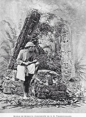
Quiriguá, Los Amates, in 1897. Picture from Alberto G. Valdeavellano
|
|
| Country | |
| Department | Izabal Department |
| Settled | 30 June 1916 |
| Area | |
| • Total | 405 sq mi (1,049 km2) |
| Elevation | 253 ft (77 m) |
| Population
(2018 census)
|
|
| • Total | 60,914 |
| • Density | 150.40/sq mi (58.069/km2) |
| Time zone | GMT_6 |
| Climate | Am |
Los Amates is a municipality located in the Izabal department of Guatemala. In 2018, its population was about 60,914 people. The current mayor is Marco Tulio Ramirez Estrada.
Los Amates sits on the Motagua River. It is only about 6 kilometers (3.7 miles) from the ancient Maya city ruins of Quiriguá.
Contents
History of Los Amates
Ancient Maya City of Quiriguá
Quiriguá is an old Maya archaeological site found in Los Amates. It's a medium-sized site, covering about 3 square kilometers (1.2 square miles). The main ceremonial area is about 1 kilometer (0.6 miles) from the Motagua River.
During the Maya Classic Period (from 200 to 900 AD), Quiriguá was an important spot. It was located where several major trade routes met. People lived here by 200 AD, and building on the acropolis (a high part of the city) started around 550 AD. A lot of grand buildings were constructed in the 8th century.
Building stopped around 850 AD, except for a short time when people returned between 900 and 1200 AD. Quiriguá shares its building and sculpture styles with the nearby city of Copán. Their histories are closely connected.
Explorers and Discoveries
The area around Los Amates was mostly empty during the Spanish colonial period. The first European to write about the Quiriguá ruins was Frederick Catherwood. He was an English architect and artist.
Catherwood visited Quiriguá in 1840. He made drawings of two large stone monuments called stelae. These drawings were published in a book by John Lloyd Stephens in 1841. Later, in 1854, Dr. Karl Scherzer wrote a longer report about the ruins.
Another important visitor was explorer and archaeologist Alfred Maudslay. He first came to Quiriguá in 1881. He was so impressed that he decided to focus on Central American archaeology.
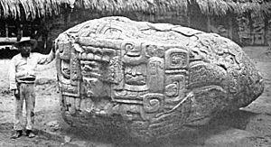
Maudslay returned three more times, until 1894. He was the first to clear the monuments and record them carefully. He took many photos, did small digs, and made plaster molds of the carvings. These molds helped share the Maya art with museums in England.
The Arrival of the Train

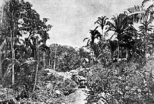
On November 22, 1896, the Northern Railroad line from Zacapa, Zacapa to Puerto Barrios opened. This was a very important project for Guatemala. It helped connect the northern part of the country, which was mostly undeveloped.
The railroad allowed businesses to explore and use the natural resources of the area. The full line connected Puerto Barrios to Guatemala City. It was built in sections, and Los Amates became one of the train stops.
In 1910, the United Fruit Company bought Quiriguá and much of the surrounding land. They used the land to grow bananas. However, they set aside about 75 acres around the ancient city as an archaeological park. This kept the jungle around the ruins safe.
More archaeological work happened from 1910 to 1914. Researchers like Edgar Lee Hewett and Sylvanus Morley studied the site. Copies of the Quiriguá stelae were shown at an exhibition in San Diego, California, in 1915. You can still see these copies at the San Diego Museum of Man.
Los Amates Becomes a Municipality
Los Amates officially became a municipality on June 30, 1916. This was decided by the president at the time, Manuel Estrada Cabrera. The decision was confirmed and organized on June 24, 1920.
For a short time, on January 28, 1944, the main town of the municipality was moved to Quiriguá. But this change didn't last long, and it was reversed on April 12 of the same year.
United Fruit Company's Influence
In the early 1920s, the United Fruit Company faced a big worker strike. This happened after a change in government in Guatemala. The company had received many special agreements from the previous president.
New worker groups started in banana farms in Morales and Los Amates. The strike grew strong. Since the new government didn't help the company stop the strike, the United Fruit Company supported another change in government in 1921. The new leader quickly stopped the strikes, which helped the company continue its operations in Izabal.
Developing the Northern Transversal Strip
In the 1960s, a region called the Franja Transversal del Norte (Northern Transversal Strip) became important. This area was known for its livestock, valuable wood for export, and archaeological sites.
Large companies were given contracts to develop the area. For example, a company from California invested a lot of money to settle parts of Petén and Alta Verapaz. The government also helped local farmers move to these less developed areas.
In 1964, a government institute defined the Northern Transversal Strip. It included the northern parts of several departments like Huehuetenango, Quiché, Alta Verapaz, and all of Izabal. This area was officially created for agricultural development in 1970.
Climate
Los Amates has a tropical monsoon climate (Köppen: Am). This means it has a wet season and a dry season, with high temperatures year-round. The municipal capital is located 78 meters (256 feet) above sea level.
| Climate data for Los Amates | |||||||||||||
|---|---|---|---|---|---|---|---|---|---|---|---|---|---|
| Month | Jan | Feb | Mar | Apr | May | Jun | Jul | Aug | Sep | Oct | Nov | Dec | Year |
| Mean daily maximum °C (°F) | 28.1 (82.6) |
29.7 (85.5) |
32.0 (89.6) |
33.3 (91.9) |
33.3 (91.9) |
32.6 (90.7) |
31.3 (88.3) |
32.0 (89.6) |
32.2 (90.0) |
30.8 (87.4) |
28.7 (83.7) |
28.1 (82.6) |
31.0 (87.8) |
| Daily mean °C (°F) | 23.9 (75.0) |
24.7 (76.5) |
26.5 (79.7) |
27.7 (81.9) |
28.2 (82.8) |
28.0 (82.4) |
27.2 (81.0) |
27.6 (81.7) |
27.6 (81.7) |
26.6 (79.9) |
24.8 (76.6) |
24.2 (75.6) |
26.4 (79.6) |
| Mean daily minimum °C (°F) | 19.8 (67.6) |
19.7 (67.5) |
21.1 (70.0) |
22.1 (71.8) |
23.2 (73.8) |
23.4 (74.1) |
23.2 (73.8) |
23.2 (73.8) |
23.1 (73.6) |
22.4 (72.3) |
21.0 (69.8) |
20.3 (68.5) |
21.9 (71.4) |
| Average precipitation mm (inches) | 98 (3.9) |
52 (2.0) |
60 (2.4) |
53 (2.1) |
163 (6.4) |
292 (11.5) |
273 (10.7) |
226 (8.9) |
310 (12.2) |
208 (8.2) |
174 (6.9) |
136 (5.4) |
2,045 (80.6) |
| Source: Climate-Data.org | |||||||||||||
See also
 In Spanish: Los Amates (Izabal) para niños
 | Laphonza Butler |
 | Daisy Bates |
 | Elizabeth Piper Ensley |


