Los Osos, California facts for kids
Los Osos (which means "the bears" in Spanish) is a town in San Luis Obispo County, California, United States. It's not officially a city, but it's a community where many people live. Los Osos is located on the beautiful Central Coast of California. In 2020, about 14,465 people lived here. For official counting, the United States Census Bureau calls Los Osos a "census-designated place" (CDP).
Quick facts for kids
Los Osos, California
|
|
|---|---|

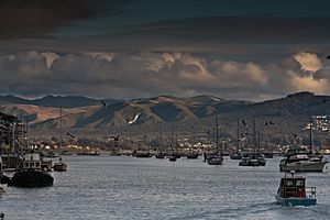
View of Los Osos from Morro Bay harbor
|
|
| Country | |
| State | |
| County | San Luis Obispo |
| Government | |
| • Type | County Government |
| Area | |
| • Total | 12.783 sq mi (33.110 km2) |
| • Land | 12.763 sq mi (33.057 km2) |
| • Water | 0.020 sq mi (0.053 km2) 0.16% |
| Elevation | 200 ft (60 m) |
| Population
(2020)
|
|
| • Total | 14,465 |
| • Density | 1,131.58/sq mi (436.877/km2) |
| Time zone | UTC−8 (Pacific (PST)) |
| • Summer (DST) | UTC−7 (PDT) |
| ZIP codes |
93402 and 93412
|
| Area code | 805 |
| GNIS feature ID | 2407812 |
| Website | https://www.losososcsd.org/ |
Contents
History of Los Osos
The first people to live in the Los Osos area were the Northern Chumash. They called themselves yak titʸu titʸu yak tiłhini in their language. They lived in this area and much of San Luis Obispo County. The Chumash name Petpatsu is thought to be near Los Osos.
These people traditionally gathered fish and shellfish from Morro Bay. They also collected acorns and vegetables from the land around them. An old Northern Chumash archaeological site has been found in Los Osos. It is on a sand dune and dates back to at least 1200 CE.
In 1542, Juan Rodríguez Cabrillo was the first European to meet the Chumash people. Today, the Northern Chumash people are still working to be officially recognized by the U.S. government. Their main group, the Northern Chumash Tribal Council, is based in Los Osos.
The Portolà Expedition and the Name "Los Osos"
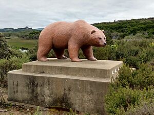
On September 7–8, 1769, the Portolà expedition traveled through the San Luis Obispo area. They were on their way to find Monterey Bay again. The explorers found many bears in the area. Padre Juan Crespi, who wrote about the journey, recorded that the soldiers named the area "Los Osos." This means "the bears" in Spanish. Some records say the full name was "llano de los osos" (plain of the bears), while others say "cañada de los osos" (glen of the bears).
The Portolà expedition was the start of Spain's efforts to explore the western part of California. They wanted to build military bases and missions. This was to prevent other countries, like Russia and Britain, from taking over the land.
Geography of Los Osos
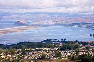
Los Osos is located in the Los Osos Valley. It's mostly a "bedroom community," meaning many people who live here travel to work in nearby cities. San Luis Obispo is about 10.6 miles (17.1 km) to the east. Morro Bay is closer, about 2.3 miles (3.7 km) to the north.
Los Osos has a small area with shops and businesses. This area is mostly along Los Osos Valley Road. There are also some shops in the Baywood section, near the bay. Most of the town is made up of homes. The population is around 14,500 people.
The United States Census Bureau says Los Osos covers about 12.8 square miles (33.1 km2). Most of this area (99.84%) is land, and a small part (0.16%) is water.
Climate in Los Osos
Los Osos has a mild warm-summer Mediterranean climate. This type of climate is common in coastal California. It means Los Osos has dry, warm summers and wet, mild winters.
Because the town is next to the Pacific Ocean, the temperatures stay moderate. This leads to warmer winters and cooler summers compared to places further inland. For example, July temperatures average around 60°F (16°C). Winters are mild, with January averaging about 55°F (13°C). It usually rains about 8 days in January.
| Climate data for Los Osos (Morro Bay, CA (1981–2010 normals, extremes 1959–present) | |||||||||||||
|---|---|---|---|---|---|---|---|---|---|---|---|---|---|
| Month | Jan | Feb | Mar | Apr | May | Jun | Jul | Aug | Sep | Oct | Nov | Dec | Year |
| Record high °F (°C) | 89 (32) |
87 (31) |
92 (33) |
100 (38) |
98 (37) |
86 (30) |
92 (33) |
94 (34) |
101 (38) |
106 (41) |
92 (33) |
81 (27) |
106 (41) |
| Mean daily maximum °F (°C) | 65.0 (18.3) |
65.6 (18.7) |
66.4 (19.1) |
66.7 (19.3) |
65.7 (18.7) |
66.9 (19.4) |
68.1 (20.1) |
69.1 (20.6) |
70.5 (21.4) |
71.4 (21.9) |
69.2 (20.7) |
64.8 (18.2) |
67.4 (19.7) |
| Daily mean °F (°C) | 54.8 (12.7) |
55.9 (13.3) |
56.8 (13.8) |
57.2 (14.0) |
57.9 (14.4) |
59.7 (15.4) |
61.6 (16.4) |
62.3 (16.8) |
62.5 (16.9) |
61.8 (16.6) |
58.8 (14.9) |
54.6 (12.6) |
58.7 (14.8) |
| Mean daily minimum °F (°C) | 44.6 (7.0) |
46.2 (7.9) |
47.3 (8.5) |
47.7 (8.7) |
50.2 (10.1) |
52.5 (11.4) |
55.0 (12.8) |
55.6 (13.1) |
54.6 (12.6) |
52.2 (11.2) |
48.5 (9.2) |
44.5 (6.9) |
49.9 (9.9) |
| Record low °F (°C) | 23 (−5) |
22 (−6) |
28 (−2) |
31 (−1) |
33 (1) |
39 (4) |
40 (4) |
40 (4) |
41 (5) |
36 (2) |
31 (−1) |
22 (−6) |
22 (−6) |
| Average precipitation inches (mm) | 3.57 (91) |
3.77 (96) |
3.29 (84) |
1.10 (28) |
0.43 (11) |
0.08 (2.0) |
0.01 (0.25) |
0.05 (1.3) |
0.24 (6.1) |
0.82 (21) |
1.40 (36) |
2.72 (69) |
17.48 (444) |
| Average precipitation days (≥ 0.01 in) | 7.8 | 9.2 | 7.8 | 4.9 | 1.7 | 0.6 | 0.4 | 0.5 | 1.5 | 3.0 | 5.0 | 7.1 | 49.5 |
| Source: NOAA | |||||||||||||
People of Los Osos
Los Osos was once combined with Baywood Park for census purposes. But for the 2010 census, they became separate areas. The 2020 United States Census reported that Los Osos had a population of 14,465 people. The population density was about 1,133 people per square mile (437 per km2).
Most people in Los Osos are White (86.8%). Other groups include African American (1.2%), Native American (3.6%), and Asian (7.3%). About 15.8% of the population is Hispanic or Latino.
Most people (99.5%) live in homes, while a small number live in group housing. The average household size is 2.40 people. About 15% of the population is under 18 years old. About 27.7% of the population is 65 years or older.
Parks and Wildlife in Los Osos
Los Osos has several beautiful natural areas. The Sweet Springs Nature Preserve is a notable spot, covering 32 acres (13 ha).
Los Osos is also the gateway to Montaña de Oro State Park. Los Osos Valley Road leads to the coast at the south end of Estero Bay and continues into the state park. Morro Bay State Park is just northeast of the town. The 90-acre (36 ha) Elfin Forest is on the southeast side of the water channel between Los Osos and Morro Bay State Park.
Large groups of eucalyptus trees in Los Osos attract monarch butterflies. These butterflies migrate here every year. While not often seen in neighborhoods, bears live in the nearby Los Padres National Forest, about 10 miles (16 km) away.
Education in Los Osos
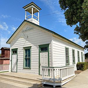
The Los Osos School District and its first school were started in 1872. The original one-room schoolhouse was used until 1958. Today, this restored schoolhouse is located in the Los Osos Community Park.
Los Osos is part of the San Luis Coastal Unified School District. Students attend these public schools:
- Elementary Schools: Baywood Elementary and Monarch Grove Elementary. Sunnyside Elementary, another elementary school, has been closed since 2004 and is used for other educational programs.
- Middle Schools: Los Osos Middle School
- High Schools: Students can attend Morro Bay High School in Morro Bay or San Luis Obispo High School in San Luis Obispo.
Town Services and Transportation
Transportation in Los Osos
Los Osos is connected to other towns by two main roads. South Bay Boulevard goes to Morro Bay, connecting to Highway 1. Los Osos Valley Road leads to San Luis Obispo.
The San Luis Obispo Regional Transit Authority provides bus service within Los Osos. It also offers express bus service to Morro Bay, Cuesta College, and San Luis Obispo.
Because Los Osos is close to the Diablo Canyon Power Plant, there are warning sirens around town. These sirens would warn residents if there were ever an emergency at the power plant.
Sewer System Development
Since 1983, some parts of Los Osos have had rules against using septic tanks. This was because too many septic tanks in one area were causing problems with nitrates in the ground. A building ban was put in place in 1989 in these areas.
For many years, there were discussions and disagreements about how to build a proper sewer system for the town. The project faced many challenges, including high costs and debates over where to build the treatment plant.
In 1999, the Los Osos Community Services District (LOCSD) was formed to take over the project. However, they also faced difficulties, including lawsuits and financial problems. In 2006, the district had to file for bankruptcy.
Eventually, the County of San Luis Obispo took over the project. After many years of planning and approvals, construction of the sewer system began in 2015. By November 2017, the project was finished. As of May 2020, almost all property owners in the project area have connected to the new sewer system.
The LOCSD still provides about half of the town's drinking water. They are also in charge of drainage, parks, street lighting, and contracting for fire, emergency, and trash services.
Notable People from Los Osos
- Art Clokey: Famous for his stop-motion clay animation, like Gumby.
- Erik Lindmark: An important death metal musician and founder of a record label.
- Jerome Long: Drafted by the Kansas City Chiefs in the 2012 NFL draft.
- Robert Osterloh: An American actor.
- Camden Toy: An actor, writer, film editor, and psychotherapist.
- Alma Ziegler: A baseball player for the All-American Girls Professional Baseball League from 1944 to 1954.
See also
 In Spanish: Los Osos para niños


