Low and Burbank's Grant, New Hampshire facts for kids
Quick facts for kids
Low and Burbank's Grant,
New Hampshire |
|
|---|---|

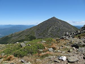
The northern slope of Mount Madison, as seen from Mount Sam Adams
|
|

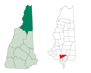
Location in Coös County, New Hampshire
|
|
| Country | United States |
| State | New Hampshire |
| County | Coös |
| Area | |
| • Total | 26.1 sq mi (67.7 km2) |
| • Land | 26.1 sq mi (67.7 km2) |
| • Water | 0 sq mi (0 km2) 0% |
| Elevation | 2,218 ft (676 m) |
| Population
(2020)
|
|
| • Total | 0 |
| Time zone | UTC-5 (Eastern) |
| • Summer (DST) | UTC-4 (Eastern) |
| Area code(s) | 603 |
| FIPS code | 33-007-43620 |
| GNIS feature ID | 872225 |
Low and Burbank's Grant is a special kind of area in Coös County, New Hampshire, United States. It's called a "grant" because it was land given or sold by the state.
This grant is entirely located within the beautiful White Mountain National Forest. What's really interesting is that, according to the 2020 census, nobody lives here! It has a population of zero.
Contents
What is a Grant?
In New Hampshire, a "grant" is an area that isn't part of any regular town. It's an unincorporated part of a county. These areas have very little or no local government, especially if no one lives there.
History of the Grant
This area got its name from two people: Clovis Lowe and Barker Burbank. They bought this land from the state back in 1832.
Exploring the Geography
Low and Burbank's Grant covers about 67.7 square kilometers (about 26.1 square miles). Almost all of this area is land, with very little water.
Mountains and Trails
The grant is located in the northern part of the White Mountains. It sits on the northern slopes of the Presidential Range and the Dartmouth Range.
Two important mountains in this area are:
- Mount Sam Adams: This is the highest point in the grant, reaching about 1,702 meters (5,584 feet) above sea level.
- Mount Madison: This mountain is about 1,636 meters (5,367 feet) tall.
The northern slopes of these mountains are very popular for hiking. They have many trails that are part of the White Mountain National Forest. Groups like the Randolph Mountain Club and the Appalachian Mountain Club have special huts and cabins here. These are used by hikers during certain seasons and are located high up, around 1,200 meters (4,000 feet) or more.
Neighboring Areas
Low and Burbank's Grant shares borders with several other towns and areas:
- To the north: Randolph
- To the northeast: Gorham
- To the east: Thompson and Meserve's Purchase
- To the southeast: Chandler's Purchase
- To the south: Crawford's Purchase
- To the west: Carroll
- To the northwest: Jefferson
Population Over Time
| Historical population | |||
|---|---|---|---|
| Census | Pop. | %± | |
| 1960 | 0 | — | |
| 1970 | 0 | — | |
| 1980 | 1 | — | |
| 1990 | 0 | −100.0% | |
| 2000 | 0 | — | |
| 2010 | 0 | — | |
| 2020 | 0 | — | |
| U.S. Decennial Census | |||
As we mentioned, the 2020 census showed that no one lives in Low and Burbank's Grant. Looking back at past censuses, it has almost always had a population of zero, except for one person recorded in 1980!
See also
 In Spanish: Low and Burbank's Grant para niños
 | Roy Wilkins |
 | John Lewis |
 | Linda Carol Brown |

