Luke, Maryland facts for kids
Quick facts for kids
Luke, Maryland
|
|||
|---|---|---|---|
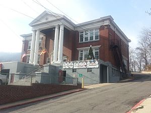
City Building in January 2014
|
|||
|
|||
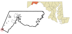
Location of Luke within Allegany County
|
|||
| Country | |||
| State | |||
| County | |||
| Incorporated | 1922 | ||
| Area | |||
| • Total | 0.31 sq mi (0.79 km2) | ||
| • Land | 0.27 sq mi (0.69 km2) | ||
| • Water | 0.04 sq mi (0.10 km2) | ||
| Elevation | 1,191 ft (363 m) | ||
| Population
(2020)
|
|||
| • Total | 85 | ||
| • Density | 319.55/sq mi (123.25/km2) | ||
| Time zone | UTC-5 (Eastern (EST)) | ||
| • Summer (DST) | UTC-4 (EDT) | ||
| ZIP code |
21540
|
||
| Area code(s) | 301, 240 | ||
| FIPS code | 24-48775 | ||
| GNIS feature ID | 2391277 | ||
Luke is a small town in Allegany County, Maryland, United States. It is located along the Potomac River, just a short distance from Westernport. The town was first known as West Piedmont. It is part of the larger Cumberland, MD-WV Metropolitan Statistical Area. In 2020, the town had a population of 85 people.
Contents
History of Luke
The town of Luke was first settled in the early 1770s. This happened after Hampshire County, West Virginia was formed in 1757. Two brothers, Henry and Thomas Davis, were among the first settlers. They built a saw mill where Luke is today. This mill made cross-ties for the Baltimore and Ohio Railroad. The railroad was building its tracks westward through the Piedmont area.
How Luke Got Its Name
In the 1880s, the railroad stopped building. The Davis brothers sold their property to William Luke. In 1888, William Luke and his sons started the Piedmont Pulp and Paper Company there. They later formed the West Virginia Pulp and Paper Company in 1897. When the railroad needed a name for its stop near the mill, they chose "Luke."
Luke's Early Growth
The land where Luke was built was once an island in the Potomac River. It was called West Piedmont and was thought to be part of Piedmont, West Virginia. But the river's path changed, and the land became part of Maryland.
For many years, Luke grew because of the paper mill. Other industries also came to the town. There was a gun factory nearby that made muskets for the United States Army. Luke also had a factory that made cars called the Maryland Steamer. There was even a post card factory.
Schools in Luke
As Luke grew, people cared more about education. Schooling first happened in homes and businesses. Later, a two-room schoolhouse was built. As more students joined, a new school opened in September 1913. This school served the town for 46 years. Students would then go to Bruce High School in Westernport. When the school closed in 1959, the building became the town's offices.
The Paper Company
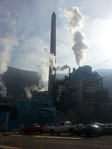
The paper mill in Luke was a very important part of the town. It was located along the Potomac River, near Backbone Mountain. For a long time, it was the biggest private employer in Allegany County. The mill's owner changed names several times. It went from West Virginia Pulp and Paper Company to Westvaco in 1969. Then it became Meadwestvaco in 2002. In 2005, its paper business was sold and became NewPage.
Environmental Concerns
The mill had a big impact on the local economy. It supported the coal, rail, and trucking industries. However, the U.S. Environmental Protection Agency listed the paper plant as a major source of mercury pollution in Maryland. Mercury is a harmful substance. In 2007, the paper plant spent $30 million to install equipment to reduce mercury releases. The plant also burned a mix of chemicals and wood waste called "black liquor". This process helped them get energy funding.
Mill Ownership Changes and Closure
In January 2015, Verso Corporation bought NewPage, which owned the Luke paper mill. By December 2017, about 700 people worked at the mill.
On April 30, 2019, Verso announced that the Luke paper mill would close by June 30, 2019. This was due to several economic reasons, including more paper being imported from other countries. Maryland's governor worked to help the employees and the community. The company said employees would receive a severance package. The mayor of Luke, Edward Clemons Jr., organized a prayer meeting for those affected by the closure. More than 100 people attended.
Production at the mill stopped on May 31, 2019. The mill's closure greatly affected the nearby communities, including Piedmont in West Virginia, and Luke and Westernport in Maryland. It also impacted businesses that supplied coal, chemicals, and timber to the mill. The mill had provided drinking water to Luke and helped pay for wastewater treatment. Verso agreed to keep providing water until a new water line from Westernport was built.
After the Closure
In 2019, a group called Upper Potomac Riverkeeper found harmful substances near the mill. These included arsenic, boron, and methyl mercury. Maryland environmental officials started investigating this leak. In November 2019, West Virginia ordered Verso to empty tanks on their side of the river. Maryland then filed a lawsuit against Verso in February 2020. The Attorney General of Maryland also filed a lawsuit in December 2019 for environmental violations.
In April 2021, Verso settled these lawsuits. They agreed to find the sources of the pollution and create a plan to clean it up. They also agreed to pay $650,000 to the state of Maryland.
In August 2023, two companies, Port River West LLC and JR Vinagro Corporation, began cleaning up the former paper mill site. This project is still ongoing and is expected to finish in the summer of 2024. There are no clear plans yet for what the 55-acre site will be used for in the future.
Geography of Luke
Luke is located on a bend in the Potomac River. It sits between the towns of Westernport and Bloomington, Maryland. The United States Census Bureau says that Luke covers a total area of about 0.31 square miles (0.79 square kilometers). Most of this area is land, and a small part is water.
Transportation
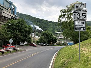
The main way to travel to and from Luke is by road. The only state highway that serves the town is Pratt Street, also known as Maryland Route 135. This road goes east to U.S. Route 220 through Westernport. It goes west to U.S. Route 219 through Oakland. A bridge over the North Branch Potomac River connects MD 135 to West Virginia Route 46.
Population Data
| Historical population | |||
|---|---|---|---|
| Census | Pop. | %± | |
| 1930 | 1,064 | — | |
| 1940 | 988 | −7.1% | |
| 1950 | 820 | −17.0% | |
| 1960 | 587 | −28.4% | |
| 1970 | 424 | −27.8% | |
| 1980 | 329 | −22.4% | |
| 1990 | 184 | −44.1% | |
| 2000 | 80 | −56.5% | |
| 2010 | 65 | −18.7% | |
| 2020 | 85 | 30.8% | |
| U.S. Decennial Census | |||
2010 Census Information
According to the census from 2010, there were 65 people living in Luke. These people lived in 33 households, and 18 of these were families. The town had about 241 people per square mile. All of the residents were White. About 6.2% of the population were Hispanic or Latino.
- 15.2% of households had children under 18.
- 39.4% were married couples living together.
- 39.4% of all households had only one person living there.
- 27.3% had someone living alone who was 65 years old or older.
- The average household size was 1.88 people.
The average age in the town was 48.5 years. About 15.4% of residents were under 18. About 33.8% were 65 years old or older. The town was 53.8% male and 46.2% female.
2020 Census Information
The 2020 census showed that Luke had a population of 85 people. Most of them (84) were White. One person was White and also Hispanic/Latino. There were 47 housing units in total. 35 of these were lived in, and 12 were empty. About 21.2% of the residents were under 18 years old.
See also
 In Spanish: Luke (Maryland) para niños


