
Lyncombe, Bath facts for kids
Quick facts for kids Lyncombe |
|
|---|---|
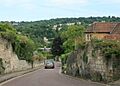
 Greenway Lane, on the former parish boundary, looking towards St Thomas à Becket Church, Widcombe |
|

Lyncombe
|
|
| Population | 5,505 (2011.Ward) |
| Unitary authority | |
| Ceremonial county | |
| Region | |
| Country | England |
| Sovereign state | United Kingdom |
| Post town | BATH |
| Postcode district | BA2 |
| Dialling code | 01225 |
| Police | Avon and Somerset |
| Fire | Avon |
| Ambulance | Great Western |
| EU Parliament | South West England |
| UK Parliament |
|
Lyncombe is a part of Bath, Somerset, in England. It's also an area used for voting, called an electoral ward. Long ago, it was a separate church area, or parish, within the Diocese of Bath and Wells.
In the mid-1800s, Lyncombe became its own parish when the larger area of Widcombe and Lyncombe was divided. However, it stopped being a separate parish in the late 1960s. The village of Lyncombe has been around since at least the Saxon period, even before it became part of the City of Bath.
The name Lyncombe comes from an old Celtic word, cwm, which means valley. "Lyn" is the name of the stream that flows through it. Today, Lyncombe is mostly in the western part of this valley, known as Lyncombe Vale. It stretches down to the more city-like area near the River Avon, across from Bath Spa railway station. The northern part of Lyncombe is called Bear Flat.
In 2019, the electoral ward of Lyncombe joined with the nearby area of Widcombe due to changes in voting boundaries.
Contents
A Look Back at Lyncombe's Past
Early History and Church Ownership
The land of Lyncombe was owned by the church from the 600s, starting with Osric, king of the Hwicce. A record from Bath shows that in 970, King Edgar gave 10 "hides" (an old land measurement) at Lyncombe to St Peter's church in Bath.
The Domesday Book, a famous survey from 1086, showed that the Abbot of Bath, Ælfsige, owned 10 hides in Lyncombe. After William the Conqueror died, his son, William Rufus, sold Bath, including Lyncombe, to John of Tours, the Bishop of Wells. The bishop then moved his main church to Bath.
In 1302, the Priory of Bath was allowed to hold fairs in Lyncombe. These fairs took place on the Feast of the Cross and on the feast of Saint Lawrence. Lyncombe was also part of an old administrative area called the hundred of Bath Forum.
Lyncombe as a Popular Spa Spot
When Bath became a famous spa town in the Georgian era, Lyncombe Vale was known as a beautiful place. Wealthy people often visited it, and even the famous writer Jane Austen came here during her stays in Bath.
In 1737, a man named Charles Milsom, who made barrels, found a mineral spring in Lyncombe Vale. He was trying to fix a leaky fishpond when he smelled sulfur and saw water bubbling up. He then pretended to be a doctor and invited people to drink the water. The next year, a real doctor, Dr. Hillary, wrote about the water's health benefits. Milsom and Hillary built a stone building over the spring for patients, but this made the ground weak and the spring stopped flowing.

Lyncombe House, which was near the spa, was often called "King James's Palace." People believed that James II of England and his wife, Mary of Modena, stayed there after he gave up his throne. While this story can't be fully proven, Mary did visit Bath for a long time in 1687. Later, the king joined her when the city was not safe for them. Lyncombe, being close but still private, would have been a good hiding place.
The house stayed a popular spot until the 1800s. An advertisement from 1792 in the local newspaper invited people to "A Publick Night, [at] King James's Palace, Illuminations, and far more Brilliant Fireworks that ever were exhibited in the Gardens."
Industry and Parish Changes
During the Industrial Revolution, Lyncombe and Widcombe were known for making woollen cloth. In 1831, 565 men over 20 worked in this industry. The part of Lyncombe closest to the river was where factories were, while Lyncombe Vale remained a quiet, natural area.
In 1835, a law called the Municipal Corporations Act 1835 made the city of Bath bigger, including all of Lyncombe and Widcombe. Twenty years later, in 1855, as more people moved to the area, Widcombe and Lyncombe were split into two separate church parishes. St Mark's became the main church for Lyncombe, and St Matthews for Widcombe.
The boundaries for the new Lyncombe parish started at the northwest corner, where it met Twerton and the River Avon. It then followed the middle of the River Avon eastward to Lower Widcombe Mill. From there, it went south along Lyncombe Hill, southwest along Greenway-lane, and south again along Entry Hill, reaching the Cross Keys Inn near South Stoke. It then went west along the border with South Stoke, meeting Englishcombe, and finally north along the borders of Englishcombe and Twerton, back to the starting point.
In 1972, because fewer people lived there and attended church, the Lyncombe parish was officially closed. It became part of a new parish called Saint Bartholomew, located in nearby Oldfield Park.
Images for kids
-
Greenway Lane, on the former parish boundary, looking towards St Thomas à Becket Church, Widcombe
