
Lạng Sơn province facts for kids
Quick facts for kids
Lạng Sơn Province
Tỉnh Lạng Sơn
|
|
|---|---|
|
From top, left to right: Mount Mẫu Sơn, Diên Khánh Tự, Tam Thanh Cave, and Lạng Sơn City.
|
|

Location of Lạng Sơn within Vietnam
|
|
| Country | |
| Region | Northeast |
| Capital | Lạng Sơn |
| Subdivision | 1 city, 10 rural districts |
| Government | |
| • Type | Province |
| • Body | Lạng Sơn Provincial People's Council |
| Area | |
| • Province | 8,310.2 km2 (3,208.6 sq mi) |
| Population
(2021)
|
|
| • Province | 788,670 |
| • Density | 94.9039/km2 (245.7999/sq mi) |
| • Urban | 164,985 |
| Ethnic groups | |
| • Nùng | 42.90% |
| • Tày | 36.08% |
| • Vietnamese | 16.09% |
| • Dao | 3.61% |
| • Others | 1.32% |
| Time zone | UTC+7 (ICT) |
| Area codes | 205 |
| ISO 3166 code | VN-09 |


Lạng Sơn is a province in northern Vietnam. Its capital city is also called Lạng Sơn. This city is very important because it's right on the border with China. It's about 137 kilometers (85 miles) northeast of Hanoi, Vietnam's capital. You can reach it by train or road.
Lạng Sơn province shares borders with several other Vietnamese provinces. These include Cao Bằng province, Bắc Giang province, Bắc Kạn province, Quảng Ninh province, and Thái Nguyên province. It also borders China's Guangxi province. The province covers an area of about 8,310 square kilometers (3,208 square miles). In 2008, about 781,655 people lived there.
The Friendship Gate is a famous historical land crossing between China and Vietnam. It connects Lạng Sơn with Guangxi, China. Because it's a border province, Lạng Sơn is very important for trade between the two countries. It's also the northernmost point on National Route 1.
Most of Lạng Sơn's economy (80%) comes from farming and forestry. However, recently, the province has been focusing on using its rich mineral resources to help its economy grow. A very important tree grown here is the star anise. This evergreen tree has fragrant leaves and is used as a spice.
Lạng Sơn has many interesting historical places. These include the Đồng Đăng border town, which has a lot of war history. There are also two large limestone caves near Lạng Sơn town. You can also find a 16th-century fortress from the Ming dynasty.
Contents
History of Lạng Sơn Province
Early History and Trade
The history of Lạng Sơn province is closely linked to its main town, Lạng Sơn. Its story goes back to the Bronze Age. During this time, a trade route connected China and India. This route passed through Lạng Sơn, going from the Red River Delta to Nanning and Guangzhou. About 7,000 to 9,000 years ago, early people of the Bac Son culture lived in the limestone caves of the province.
The Dinh kings (968-980) wanted more trade in the area. They asked the Sung emperors of China to set up trade at Yong Zhou. Chinese records show that the Vietnamese traded perfumes, elephant ivory, rhinoceros horns, gold, silver, and salt. In return, they received Chinese fabrics. Later, under the Lý dynasty, a big market was set up at Vĩnh Bình on the Kỳ Cùng River.
Fortifications and Conflicts
In 1406, a Chinese Ming envoy crossed into Lạng Sơn. Hồ Quý Ly's soldiers attacked them and killed a prince the Ming were bringing back. Because of this, the Yongle Emperor of Ming China sent an army to punish him. This led to the Ming–Hồ War.
Between 1527 and 1592, during the Ming dynasty, Lạng Sơn was made much stronger. This was because it was so important as a border area. You can still see a fortress from this dynasty west of Lạng Sơn town on a limestone rock.
Lạng Sơn was one of the 13 original provinces in northern Vietnam. These were created in 1831 by Emperor Minh Mạng. Before that, northern Vietnam was ruled by a viceroy since the Nguyễn dynasty began in 1802.
French Occupation and World Wars
The French took control of Lạng Sơn town in 1885. It was a very busy and rich town then. The French turned it into an important military base, like their other base in Cao Bằng. In 1906, an archaeologist named Henri Mansuy found the Tham Kanh cave near Pho Binh Gia. He found unique stone tools and human remains there. Later, from 1922 to 1925, M. Coloni explored Lạng Sơn province a lot. He found 43 places linked to the ancient Bac Son culture in the mountains.
During World War II, Japan attacked Vietnam even though they had an agreement with Vichy Indo China. They entered Vietnam from China and captured Lạng Sơn on September 25, 1940. However, Vichy France complained to Emperor Hirohito. This led to a ceasefire, and Vichy forces took Lạng Sơn back.
Modern History and Border Conflicts
After Ho Chi Minh's government started in September 1945, Vietnam faced new challenges. Ho Chi Minh made an agreement with the French to deal with threats from China. This agreement said Vietnam would be free but part of the French Union. However, the French later attacked the Viet Minh in October 1947, using Lạng Sơn as their base. The Viet Minh fought back and forced the French to retreat. This marked the start of the First Indochina War.
In 1950, the Viet Minh took control of the province and its town. In February 1979, China invaded Vietnam through the border town of Don Dong. Lạng Sơn town was a main target for the Chinese army. However, the Vietnamese army successfully defended against the Chinese. This victory is now a famous story in the province. The border area has been rebuilt, and trade between Vietnam and China is now very active.
The town of Lạng Sơn was badly damaged during the 1979 invasion. But it has been rebuilt since then. The older part of the town, near the Kyu Kung River, still has some interesting historical places.
On June 7, 1949, the Lộc Bình district became part of Lạng Sơn from Hải Ninh province. Lạng Sơn province has had its current 10 districts since 1978.
Geography and Climate
Mountains and Rivers
Lạng Sơn province is known for its karstic limestone mountains and valleys. Mountains and forests cover 80% of the province. The province is about 123 kilometers (76 miles) long from north to south and 126 kilometers (78 miles) wide from west to east. The land is, on average, 252 meters (827 feet) above sea level. The lowest point is 20 meters (66 feet) in the south of Hữu Lũng District. The highest point is Mount Mẫu Sơn, which is 1,541 meters (5,056 feet) high. Sometimes, snow falls on Mount Mẫu Sơn in winter. The Bac Son Mountains in the province are made of limestone. High mountain ridges surround fertile valleys, creating beautiful scenery.
The Kỳ Cùng River flows for about 243 kilometers (151 miles) through Lạng Sơn town. This river creates flat plains in its valley. The Kỳ Cùng River starts in the mountains of Bắc Xa at 1,166 meters (3,825 feet) high. Other rivers in the province include the Bản Thín River, the Bắc Giang River, and the Bắc Khê River. The Thương Là River is the second largest river in the province.
Border Crossings and Transport
Lạng Sơn has two international border crossings. The most used one is the Friendship Gate, also called Hữu Nghị Quan. It's at Đồng Đăng and connects to Pingxiang town in China. This is a historic land link between China and Vietnam. The border is open daily from 7:00 AM to 5:00 PM. You walk about 500 meters (1,640 feet) through a neutral zone between the two countries.
An international train service runs from Hanoi to Beijing (China) twice a week. This train passes through Lạng Sơn Town and Đồng Đăng. It stops for three hours at the border to complete entry checks.
Lạng Sơn is about 155 kilometers (96 miles) northwest of Hanoi. National Highways 1 and 1A pass through the province. These roads go through the Chi Lăng pass, where a famous victory happened in 1427.
Climate
Lạng Sơn province has an average yearly temperature of 17–22 °C (63–72 °F). The average yearly rainfall is between 1,200 and 1,600 millimeters (47–63 inches). Summers average 28.5 °C (83.3 °F), and winters average 12–13 °C (54–55 °F). The air is usually humid, around 80–85%. The province gets about 1,600 hours of sunlight each year.
| Climate data for Lạng Sơn | |||||||||||||
|---|---|---|---|---|---|---|---|---|---|---|---|---|---|
| Month | Jan | Feb | Mar | Apr | May | Jun | Jul | Aug | Sep | Oct | Nov | Dec | Year |
| Record high °C (°F) | 31.6 (88.9) |
36.4 (97.5) |
36.7 (98.1) |
38.2 (100.8) |
39.8 (103.6) |
38.8 (101.8) |
37.6 (99.7) |
37.7 (99.9) |
36.2 (97.2) |
34.3 (93.7) |
32.7 (90.9) |
30.2 (86.4) |
39.8 (103.6) |
| Mean daily maximum °C (°F) | 17.5 (63.5) |
18.8 (65.8) |
21.9 (71.4) |
26.5 (79.7) |
30.2 (86.4) |
31.5 (88.7) |
31.7 (89.1) |
31.3 (88.3) |
30.2 (86.4) |
27.5 (81.5) |
23.7 (74.7) |
19.8 (67.6) |
25.9 (78.6) |
| Daily mean °C (°F) | 13.1 (55.6) |
14.7 (58.5) |
18.0 (64.4) |
22.3 (72.1) |
25.5 (77.9) |
26.9 (80.4) |
27.1 (80.8) |
26.6 (79.9) |
25.2 (77.4) |
22.3 (72.1) |
18.4 (65.1) |
14.6 (58.3) |
21.3 (70.3) |
| Mean daily minimum °C (°F) | 10.1 (50.2) |
12.0 (53.6) |
15.4 (59.7) |
19.3 (66.7) |
22.1 (71.8) |
23.8 (74.8) |
24.0 (75.2) |
23.7 (74.7) |
22.2 (72.0) |
18.8 (65.8) |
14.8 (58.6) |
11.0 (51.8) |
18.1 (64.6) |
| Record low °C (°F) | −2.1 (28.2) |
−1.7 (28.9) |
0.9 (33.6) |
9.3 (48.7) |
13.7 (56.7) |
15.1 (59.2) |
18.6 (65.5) |
19.5 (67.1) |
13.2 (55.8) |
5.5 (41.9) |
1.8 (35.2) |
−1.5 (29.3) |
−2.1 (28.2) |
| Average precipitation mm (inches) | 35.4 (1.39) |
33.3 (1.31) |
50.3 (1.98) |
91.1 (3.59) |
159.4 (6.28) |
191.3 (7.53) |
236.0 (9.29) |
227.6 (8.96) |
141.8 (5.58) |
78.9 (3.11) |
41.4 (1.63) |
24.2 (0.95) |
1,318.2 (51.90) |
| Average rainy days | 9.3 | 10.0 | 13.2 | 12.5 | 13.5 | 15.6 | 16.6 | 17.2 | 12.4 | 8.6 | 6.5 | 5.9 | 141.3 |
| Average relative humidity (%) | 80.4 | 82.5 | 83.6 | 82.7 | 81.6 | 83.6 | 84.2 | 85.9 | 84.7 | 82.0 | 80.0 | 78.0 | 82.5 |
| Mean monthly sunshine hours | 74.5 | 59.2 | 59.2 | 98.1 | 171.2 | 161.4 | 180.2 | 171.3 | 174.4 | 157.5 | 136.3 | 115.5 | 1,561.4 |
| Source 1: Vietnam Institute for Building Science and Technology | |||||||||||||
| Source 2: The Yearbook of Indochina | |||||||||||||
Administrative Divisions
Lạng Sơn province is divided into 11 main areas. These include one city and 10 rural districts. These areas are further split into 200 smaller communities.
| Administrative divisions of Lạng Sơn | |||||||||||||||||||||||||||||||||||||||||||||||
|---|---|---|---|---|---|---|---|---|---|---|---|---|---|---|---|---|---|---|---|---|---|---|---|---|---|---|---|---|---|---|---|---|---|---|---|---|---|---|---|---|---|---|---|---|---|---|---|
|
|
||||||||||||||||||||||||||||||||||||||||||||||
| Source: 2019 Viet Nam Population and Housing Census | |||||||||||||||||||||||||||||||||||||||||||||||
People and Culture

In 2019, Lạng Sơn Province had a population of 781,655 people. This means there were about 94 people per square kilometer. More males lived in the province (399,410) than females (382,245). Most people (621,841) lived in rural areas, while 159,814 lived in cities.
The Vietnamese government recognizes about 40 different ethnic groups in Lạng Sơn. Each group has its own language, traditions, and unique culture. The largest group is the Nùng, making up 42.90% of the population. The Tày are the second largest at 36.08%. Vietnamese people make up 16.09%. Other groups include the Dao, Hoa, Sán Chay, and Hmong.
The Nung people speak different dialects. These include Nùng Phan Slinh in eastern Lạng Sơn, Nùng Cháo around Lạng Sơn city, and Nùng Inh in western Lạng Sơn.
Economy and Resources
Lạng Sơn's economy mainly relies on farming and forestry, making up 80% of its income. The province has many valuable minerals. These include bauxite, phosphate, and coal. There are also amounts of gold, silver, and lead.
Agriculture and Farming
The main crops grown here are rice, sweet potato, maize, and manioc. In 1986, rice was grown on 40,000 hectares of land. These crops are usually grown in the valleys of the Bac Son Mountains, Binh Gia Mountains, and Van Quan Mountains. They also grow along the plains of the Kỳ Cùng River and the Thuong River. Some districts, like Hữu Lũng District, grow sugar cane, oranges, and pineapples. Others grow tea and plums.
Animal farming is also important in Lạng Sơn. In 1986, there were 140,000 buffalo and oxen, and 150,000 pigs. The province is also famous for its special That Khe duck.
Star Anise Production
The most important tree grown in Lạng Sơn is the star anise (Illicium verum). This evergreen tree has fragrant leaves and is a key spice. Lạng Sơn province grows the most star anise in Vietnam, with about 9,000 hectares of these trees. Most of them are in the Văn Quan District.
In the past, state farms managed these trees. But since the 1990s, local families have been given control to manage them. There are plans to plant even more star anise trees, aiming for 20,000 hectares.
Historical Sites to Explore
Lạng Sơn province has many interesting historical places. The Đồng Đăng Border town is famous for its war history and attracts many visitors. There are also two large limestone caves and a 16th-century fortress from the Ming dynasty.
Tam Thanh and Nhi Thanh Caves
The two main caves are called Tam Thanh Cave and Nhi Thanh Cave. They are close to Lạng Sơn town and have Buddhist altars inside. They are also well-lit.
The Tam Thanh Cave is very big and has three chambers. It has a water pond and a window that offers amazing views of the rice fields outside. The first chamber on the right has the Tam Giao Pagoda, built in 1777, with six shrines. The second chamber on the left also has shrines. The Ngoc Tuyen River flows through this cave, which is quite unusual and creates a "dramatic sight."
The Nhi Thanh Cave is about 700 meters (2,300 feet) from Tam Thanh Cave. It was found in the 18th century by Ngô Thin Sy, a military leader. His poems are carved at the cave's entrance. A plaque near the cave shows a French resident of Lạng Sơn. The Ngoc Tuyen River also flows through this cave.
Ming Dynasty Citadel
The Ming dynasty citadel is a 16th-century fortress. It's located in a quiet area on a rocky outcrop. You can reach it from Lạng Sơn city using the Tam Tinh road. Steps from the roadside lead up to the old fortress. Lạng Sơn city also has old walls that were built in the 18th century.
Forests and Wildlife
Lạng Sơn is a northern mountainous province with rich forests. These forests have many different kinds of plants and animals. The karstic limestone areas, which cover 5% of Vietnam's natural forests, are very important for wildlife. Lạng Sơn and Cao Bằng provinces have a large part of these limestone formations.
These limestone areas are home to 69 types of mammals. Five of these are found only in Vietnam, and 26 are rare species. Local villagers value these formations because they provide water for farming. They also offer wood for fuel, medicinal plants, and building materials for homes. In Lạng Sơn, they are a great source of water for growing rice. The limestone formations also allow annona trees to grow well. These trees bring good income to the villagers.
Images for kids
-
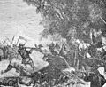
Battle of Núi Bop
-

Capture of Lạng Sơn
-
-
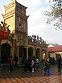
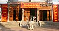
Temple in Lạng Sơn


See also
 In Spanish: Provincia de Lạng Sơn para niños
