Madison County, Tennessee facts for kids
Quick facts for kids
Madison County
|
|
|---|---|

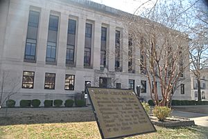
Madison County Courthouse in March 2012
|
|

Location within the U.S. state of Tennessee
|
|
 Tennessee's location within the U.S. |
|
| Country | |
| State | |
| Founded | 1821 |
| Named for | James Madison |
| Seat | Jackson |
| Largest city | Jackson |
| Area | |
| • Total | 559 sq mi (1,450 km2) |
| • Land | 557 sq mi (1,440 km2) |
| • Water | 1.5 sq mi (4 km2) 0.3%% |
| Population
(2020)
|
|
| • Total | 98,823 |
| • Density | 176/sq mi (68/km2) |
| Time zone | UTC−6 (Central) |
| • Summer (DST) | UTC−5 (CDT) |
| Congressional district | 8th |
Madison County is a county located in the western part of Tennessee. It's a place where many people live and work.
In 2020, about 98,823 people lived here. The main city and county center is Jackson. Madison County is also part of the larger Jackson, TN area.
Contents
History of Madison County
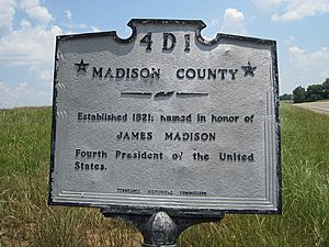
Madison County was created in 1821. It was named after James Madison, one of the important leaders who helped start the United States. He was also a president.
This land was bought by the United States in 1818 from the Chickasaw people. Later, in 1830, a law called the Indian Removal Act was passed. This law forced most Chickasaw people to move away from Tennessee. They had to go west, across the Mississippi River.
Ancient History: Pinson Mounds
Madison County is home to Pinson Mounds. This is a very old site with large earth mounds. These mounds were built by Native American people long ago, between the years 1 and 500 CE.
Pinson Mounds is one of the biggest mound sites in the United States. It even has the second-tallest earth mound in the country!
Geography of Madison County
Madison County covers about 559 square miles. Most of this area, about 557 square miles, is land. Only a small part, about 1.5 square miles, is water.
Travel and Nature
The county has its own airport, called McKellar-Sipes Regional Airport (MKL). This airport helps people travel to and from the area.
There's also a large lake here called Lake Graham. It's about 500 acres big. People use it for fun activities like fishing and to help protect wildlife. It's located about 5 miles east of Jackson.
Neighboring Counties
Madison County shares its borders with several other counties:
- Gibson County (to the north)
- Carroll County (to the northeast)
- Henderson County (to the east)
- Chester County (to the southeast)
- Hardeman County (to the south)
- Haywood County (to the west)
- Crockett County (to the northwest)
Protected Natural Areas
Several areas in Madison County are protected to preserve nature and history:
- Pinson Mounds State Archaeological Park (where the ancient mounds are)
- Middle Fork Bottoms State Park
- South Fork Waterfowl Refuge
- Lake Graham
Major Roads
Important highways that run through Madison County include:
People of Madison County
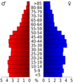
The number of people living in Madison County has grown a lot over the years. In 1830, there were about 11,594 people. By 2020, the population had grown to 98,823.
Who Lives Here?
The 2020 United States census showed that Madison County is home to many different people.
| Race | Number of People | Percentage |
|---|---|---|
| White (not Hispanic) | 53,264 | 53.9% |
| Black or African American (not Hispanic) | 35,837 | 36.26% |
| Native American | 175 | 0.18% |
| Asian | 1,227 | 1.24% |
| Pacific Islander | 13 | 0.01% |
| Other/Mixed | 3,585 | 3.63% |
| Hispanic or Latino | 4,722 | 4.78% |
In 2020, there were 98,823 people living in 38,930 households. About 25,748 of these were families.
Healthcare Services
West Tennessee Healthcare is the main public hospital system in Madison County. It was started in 1949. The county helps choose some of the people who manage this hospital system.
Fun Fact about Media
You might have heard of Madison County in a song! The famous singer Kenny Rogers mentions this Madison County in his song "Reuben James."
Communities in Madison County
Madison County has several cities and smaller communities.
Cities
- Humboldt (most of it is in a different county, Gibson County)
- Jackson (This is the county's main city and where the county government is located.)
- Medon (part of it is in Hardeman County)
- Three Way
Designated Places
- Mercer (partly in Haywood County)
Smaller Communities
These are smaller towns or areas that are not officially cities:
- Adair
- Beech Bluff
- Claybrook
- Denmark
- Five Points
- Huntersville
- Leighton
- Neely
- Oakfield
- Pinson
- Spring Creek
Education in Madison County
Madison County has several schools and colleges.
The public schools are part of the Jackson-Madison County School System.
For higher education, there are:
- Lane College: A private college that has a special history for Black students. It is connected to the Christian Methodist Episcopal Church.
- Union University: A private school linked to the Tennessee Baptist Convention.
- West Tennessee School for the Deaf: A school run by the state for students who are deaf.
Images for kids
See also
 In Spanish: Condado de Madison (Tennessee) para niños


