Mahogany Mountain facts for kids
Quick facts for kids Mahogany Mountain |
|
|---|---|
| Highest point | |
| Elevation | 6,526 ft (1,989 m) NAVD 88 |
| Prominence | 1,892 ft (577 m) |
| Geography | |
| Location | Malheur County, Oregon, U.S. |
| Parent range | Owyhee Mountains |
| Topo map | USGS McCain Creek |
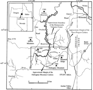
Mahogany Mountain is an ancient caldera volcano located on the border of Oregon and Idaho. A caldera is a large, bowl-shaped hollow that forms when the ground above a magma chamber collapses after a volcanic eruption. This mountain is found in Malheur County in Oregon and Owyhee County in Idaho.
Scientists believe its last eruption happened about 15.5 million years ago. This powerful eruption sent out layers of volcanic rock called rhyolite and tuff. These materials created the amazing rock formations you can see today in a place called Leslie Gulch.
Near Mahogany Mountain, you'll find the Owyhee River. Long ago, Native Americans used this river for fishing and camping. The weather here can be very extreme, meaning it gets very cold in winter and very hot in summer. You'll mostly see shrubs and patches of juniper trees growing in this area.
Contents
Exploring Mahogany Mountain's Geology
Mahogany Mountain is part of a large area known as the Basin and Range Province. The volcano's most recent activity was around 15 million years ago. This was a time when many volcanoes were erupting, sending out ash and other volcanic materials.
Mahogany Mountain formed at the same time as other volcanoes like Three Fingers and Castle Peak. Today, the mountain looks rugged and worn down because of erosion by wind and water. Its top is covered with pine forests.
The caldera itself is narrow and shaped like a ridge. It has very steep sides and a sharp drop-off on its northwest side. The mountain is made up of volcanic rock called rhyolite tuff and layers of sedimentary rock.
The Unique Leslie Gulch
Inside the volcano's depression, you'll find Leslie Gulch. This area clearly shows layers of ash and tuff from the ancient eruptions. You can also see leftover volcanic rocks scattered around.
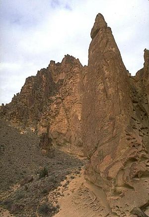
The gulch is famous for its incredible rock formations. These unique shapes were created by the ash that erupted from the volcano about 15.5 million years ago. It's like a natural sculpture garden!
A Glimpse into History
The Owyhee River, which flows near Mahogany Mountain, was an important place for Native Americans. They used the river as early as 5,000 years ago, long before Europeans settled in the area.
It was a vital source of food, providing fish and animals for hunting. Native American groups often set up their camps along the river's banks.
Climate and Wildlife
The area around Mahogany Mountain experiences very cold winters and very hot summers. It doesn't get much rain, with only about 25 centimeters (10 inches) falling each year.
Most of the plants you'll see are Steppe-like shrubs, which are tough and can survive in dry conditions. You'll also find patches of juniper trees. This region is home to many different animals, with 64 known types of mammals living here.
Images for kids
 | Delilah Pierce |
 | Gordon Parks |
 | Augusta Savage |
 | Charles Ethan Porter |


