Malibu Creek facts for kids
Quick facts for kids Malibu Creek |
|
|---|---|

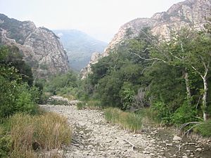
Malibu Creek, dry river bed,
with the Goat Buttes in the background |
|
|
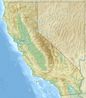
Location of the mouth of Malibu Creek in California
|
|
| Other name(s) | Malaga Creek Maliba Sequit Creek Malibo Creek Topanga Malibu Sequit Creek |
| Country | United States |
| State | California |
| Region | Los Angeles County |
| Physical characteristics | |
| Main source | 4 mi (6 km) 34°07′22″N 118°47′38″W / 34.12278°N 118.79389°W |
| River mouth | Malibu Lagoon then Santa Monica Bay, Pacific Ocean Malibu, California 3 ft (0.91 m) 34°01′54″N 118°40′47″W / 34.03167°N 118.67972°W |
| Basin features | |
| Tributaries |
|
Malibu Creek is a stream that flows all year in western Los Angeles County, California. It collects water from the southern Conejo Valley and Simi Hills. The creek then flows south through the Santa Monica Mountains and empties into Santa Monica Bay in Malibu.
The area that Malibu Creek drains, called its watershed, covers about 109 square miles (282 km²). Its smaller streams reach as high as 3,000 feet (914 m) into Ventura County. The main part of Malibu Creek starts south of Westlake Village. This is where Triunfo Creek and Lobo Canyon Creek join together. From there, it flows 13.4 miles (21.6 km) to Malibu Lagoon.
Malibu Canyon is a main path through the mountains. Malibu Canyon Road is a big road that connects the coast to the inland valley. Malibu Creek starts at Malibou Lake, which is held back by the Malibu Lake Dam. Further downstream, the creek drops 100 feet (30 m) over the Rindge Dam. Then, it carves its final path into Malibu Lagoon.
Contents
History of Malibu Creek
For many centuries, the area around Malibu Creek was an important place for Native American life. It was the border between the Chumash tribes, who lived to the northwest, and the Gabrieliño people, who lived to the south and east.
The name of the creek likely comes from the Chumash word U-mali-wu. This word means "it makes a loud noise there." The Spanish wrote this as 'Malibu'. This spelling appeared in a land grant document on July 12, 1805.
Parts of the creek were dammed in 1903, 1922, and 1924. Malibu Canyon Road was opened for cars in 1952.
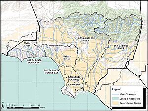
Malibu Creek Watershed
A watershed is an area of land where all the water drains into a single river or lake. Malibu Creek has several smaller streams, called tributaries, that drain the Santa Monica Mountains.
These tributaries include streams that flow into Lake Sherwood. From there, water goes through Potrero Valley Creek to Westlake Lake. Then it flows down Triunfo Creek to meet Lobo Canyon Creek. This meeting point is where Malibu Creek officially begins.
Other important tributaries are Medea Creek, Las Virgenes Creek, and Cold Creek. Medea Creek and Malibu Creek join to form Malibu Lake. Further downstream, Las Virgenes Creek joins Malibu Creek inside Malibu Creek State Park.
How People Changed the River
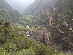
The Rindge Dam creates a 100-foot (30 m) waterfall in Malibu Creek State Park. The water falls into a deep pool that always has water. Eventually, the creek flows into the 13-acre (5.3 ha) Malibu Lagoon.
The Tapia Water Reclamation Facility cleans wastewater and then releases it into the creek. The Las Virgenes Municipal Water District also releases water into the creek. They do this when the water flow drops below 2.5 feet per second (0.76 m/s). This helps keep the aquatic habitat healthy for fish like steelhead trout and other threatened and endangered species.
The National Marine Fisheries Service requires this water release to protect the environment. The water district also provides water for the large lake in Westlake Village. This happens when their wells do not have enough water. Even in dry summer months, water from the lake must be released into the creek. This is part of an agreement with the California State Water Resources Control Board.
Wildlife in Malibu Creek
Malibu Creek and the area around it are home to many plants and animals. These species are native to this region. You can find a variety of wildflowers, Valley Oaks, and Sycamore trees. There is also a small group of Redwood trees planted near Century Lake. These redwoods help keep the water cooler.
Many amphibians live in the creek, such as newts, salamanders, toads, and frogs. Other animals like turtles, herons, and even mountain lions depend on the creek and its inhabitants for survival.
Steelhead Trout in Malibu Creek
Steelhead trout (Oncorhyncus mykiss irideus) are a type of fish. Their populations in Southern California have dropped a lot. In the past, 32,000 to 46,000 adult steelhead would return each year. Now, fewer than 500 adult fish return. This includes fish in Malibu Creek.
Scientists have studied the steelhead in Malibu Creek and other rivers. They found that these fish are native to the area. They are not from fish farms.
A sand bar often blocks the mouth of Malibu Creek Lagoon. This stops steelhead from the ocean from entering the creek. But during the rainy winter, high water flows break open the sand bar. This allows the fish to enter the estuary.
The fish quickly reach a barrier: the 100-foot (30 m) high Rindge Dam. This dam stops them from going further upstream. It limits them to only the lowest 2 miles (3.2 km) of the creek. Historically, they could use over 70 miles (112 km) of habitat.
The Rindge Dam was built in 1926 to store water and control floods. But now, the reservoir behind it is completely filled with mud and sand. So, it no longer works as a reservoir. For the past ten years, groups have been trying to remove the dam. This would help the steelhead reach their old spawning grounds upstream.
In 1997, the southern group of steelhead trout was added to the federal list of endangered species. Malibu Creek was the southernmost boundary for this protected group. Since then, their protected range has been extended all the way to the U.S./Mexican border.
In 2006, many native and non-native fish and other water animals died in Malibu Creek. This was likely due to pollution, high temperatures, and low oxygen. The steelhead trout population dropped to zero by November 2006. However, surveys in 2008 found five adult steelhead returning. They also found over 2,200 young steelhead (smolts).
Other Wildlife Concerns
The rare plant called Malibu baccharis (Baccharis malibuensis) grows only in the Malibu Creek area.
Introduced crayfish are a problem in the creek. They eat native fish, water insects, and newts. They also eat the eggs and tadpoles of frogs and toads.
Geology of Malibu Creek
Malibu Creek flows through a part of the Santa Monica Mountains. This area is largely covered by something called the Conejo Volcanics. This is a field of volcanic rock that formed during the Miocene epoch.
Several sections of volcanic rock, including the Conejo Volcanics, formed along the California coast. This happened because of big shifts in the Earth's tectonic plates. These shifts forced hot magma through the Earth's crust. This magma then cooled and formed the rock formations we see today.
Parks and Recreation
Almost all of the Malibu Creek watershed is part of the Santa Monica Mountains National Recreation Area. Most of Malibu Creek was included in Malibu Creek State Park in 1976. The section near Century Lake is very popular with people who like to swim, climb, and take pictures.


