
Malone, New York facts for kids
Quick facts for kids
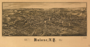
Malone, New York
|
|
|---|---|
 |
|

Malone, New York
Location in New York
|
|
| Country | United States |
| State | New York |
| Government | |
| • Type | Town Council |
| Area | |
| • Total | 102.80 sq mi (266.26 km2) |
| • Land | 101.52 sq mi (262.94 km2) |
| • Water | 1.28 sq mi (3.32 km2) |
| Elevation | 790 ft (240 m) |
| Population
(2020)
|
|
| • Total | 5,400 |
| • Density | 138.8/sq mi (53.59/km2) |
| Time zone | UTC−5 (Eastern (EST)) |
| • Summer (DST) | UTC−4 (EDT) |
| ZIP Code |
12953
|
| Area code(s) | 518 |
| FIPS code | 36-033-44721 |
| GNIS feature ID | 979185 |
Malone is a town in Franklin County, New York, United States. In 2020, about 12,433 people lived here. The town also includes a village that shares the name Malone. It's located in the north-central part of Franklin County.
Contents
History of Malone

Malone became a town in 1805. It was originally part of the town of Chateaugay. The town was first called "Harison" after Richard Harison, who bought the land. In 1808, its name changed to "Ezraville" after Ezra L'Hommedieu. Finally, in 1812, it was named "Malone."
During the War of 1812, British troops from what is now Canada attacked the village.
Former Governor Mario Cuomo helped bring more economic activity to the county. This included developing various facilities to create jobs and improve the local economy.
From 1901 to 1958, a special train service connected Malone with Montreal, Quebec. This service was run by the New York Central Railroad.
Famous People from Malone
Many notable people have connections to Malone. Here are a few:
- Tom Browning: A baseball pitcher who won the World Series with the Cincinnati Reds.
- Ovila Cayer (1844–1909): Received the Medal of Honor for his bravery during the Battle of Globe Tavern.
- Orville Gibson (1856–1911): The person who started the famous Gibson Guitar Corporation.
- Michael Hastings (1980–2013): An investigative journalist.
- Bob Mould (born 1960): A solo musician and former member of alternative rock bands Hüsker Dü and Sugar.
- Charles L. Russell (1844–1910): Received the Medal of Honor for his actions during the Battle of Spotsylvania Court House.
- Frank Tolan (1854–99): Received the Medal of Honor for his bravery at the Battle of the Little Bighorn.
- William A. Wheeler (1819–87): The 19th Vice President of the United States. He is buried in Malone. His old home is now the Elks Lodge.
- Almanzo Wilder (1857–1949): The husband of Laura Ingalls Wilder, who wrote the Little House on the Prairie books.
Geography and Climate

Malone covers an area of about 102.8 square miles (266.3 square kilometers). Most of this area is land, with a small part being water.
Major roads like U.S. Route 11 and New York State Route 11B run east-west through the town. New York State Route 30 and New York State Route 37 run north-south.
The Salmon River flows north through the middle of the town. The Trout River flows through the northeastern part.
Malone has a climate with warm summers. The hottest temperature ever recorded was 95°F (35°C) in July 2020. The coldest was -31°F (-35°C) in February 1993.
| Climate data for Malone, New York, 1991–2020 normals, extremes 1983–present | |||||||||||||
|---|---|---|---|---|---|---|---|---|---|---|---|---|---|
| Month | Jan | Feb | Mar | Apr | May | Jun | Jul | Aug | Sep | Oct | Nov | Dec | Year |
| Record high °F (°C) | 65 (18) |
66 (19) |
78 (26) |
87 (31) |
94 (34) |
92 (33) |
95 (35) |
94 (34) |
90 (32) |
85 (29) |
76 (24) |
67 (19) |
95 (35) |
| Mean maximum °F (°C) | 51.9 (11.1) |
48.0 (8.9) |
59.2 (15.1) |
76.1 (24.5) |
82.4 (28.0) |
86.8 (30.4) |
87.3 (30.7) |
86.6 (30.3) |
83.9 (28.8) |
75.5 (24.2) |
66.0 (18.9) |
55.1 (12.8) |
89.2 (31.8) |
| Mean daily maximum °F (°C) | 24.1 (−4.4) |
26.5 (−3.1) |
35.3 (1.8) |
50.4 (10.2) |
64.4 (18.0) |
72.6 (22.6) |
77.0 (25.0) |
75.4 (24.1) |
68.7 (20.4) |
55.1 (12.8) |
42.6 (5.9) |
30.8 (−0.7) |
51.9 (11.0) |
| Daily mean °F (°C) | 14.9 (−9.5) |
16.8 (−8.4) |
26.2 (−3.2) |
40.7 (4.8) |
54.3 (12.4) |
63.3 (17.4) |
67.8 (19.9) |
65.8 (18.8) |
58.5 (14.7) |
46.4 (8.0) |
34.8 (1.6) |
22.9 (−5.1) |
42.7 (6.0) |
| Mean daily minimum °F (°C) | 5.7 (−14.6) |
7.2 (−13.8) |
17.2 (−8.2) |
31.1 (−0.5) |
44.3 (6.8) |
54.1 (12.3) |
58.7 (14.8) |
56.2 (13.4) |
48.2 (9.0) |
37.7 (3.2) |
27.0 (−2.8) |
15.1 (−9.4) |
33.5 (0.9) |
| Mean minimum °F (°C) | −18.3 (−27.9) |
−13.7 (−25.4) |
−5.3 (−20.7) |
17.6 (−8.0) |
30.0 (−1.1) |
40.5 (4.7) |
47.4 (8.6) |
44.0 (6.7) |
34.0 (1.1) |
24.5 (−4.2) |
9.2 (−12.7) |
−9.1 (−22.8) |
−20.3 (−29.1) |
| Record low °F (°C) | −30 (−34) |
−31 (−35) |
−21 (−29) |
5 (−15) |
24 (−4) |
30 (−1) |
40 (4) |
38 (3) |
26 (−3) |
19 (−7) |
−5 (−21) |
−29 (−34) |
−31 (−35) |
| Average precipitation inches (mm) | 2.42 (61) |
1.98 (50) |
2.37 (60) |
3.31 (84) |
3.33 (85) |
4.50 (114) |
3.97 (101) |
3.85 (98) |
4.04 (103) |
4.30 (109) |
3.11 (79) |
2.74 (70) |
39.92 (1,014) |
| Average snowfall inches (cm) | 22.7 (58) |
20.2 (51) |
17.0 (43) |
7.1 (18) |
0.3 (0.76) |
0.0 (0.0) |
0.0 (0.0) |
0.0 (0.0) |
0.0 (0.0) |
1.4 (3.6) |
8.8 (22) |
20.6 (52) |
98.1 (248.36) |
| Average extreme snow depth inches (cm) | 13.4 (34) |
14.9 (38) |
15.7 (40) |
6.3 (16) |
0.2 (0.51) |
0.0 (0.0) |
0.0 (0.0) |
0.0 (0.0) |
0.0 (0.0) |
1.0 (2.5) |
4.7 (12) |
9.6 (24) |
20.1 (51) |
| Average precipitation days (≥ 0.01 in) | 16.9 | 13.8 | 13.1 | 13.5 | 13.9 | 14.6 | 13.1 | 12.1 | 12.0 | 14.4 | 14.7 | 17.0 | 169.1 |
| Average snowy days (≥ 0.1 in) | 13.8 | 11.5 | 8.2 | 3.5 | 0.2 | 0.0 | 0.0 | 0.0 | 0.0 | 0.8 | 5.3 | 11.3 | 54.6 |
| Source 1: NOAA | |||||||||||||
| Source 2: National Weather Service | |||||||||||||
Population and People
| Historical population | |||
|---|---|---|---|
| Census | Pop. | %± | |
| 1820 | 1,150 | — | |
| 1830 | 2,207 | 91.9% | |
| 1840 | 3,229 | 46.3% | |
| 1850 | 4,550 | 40.9% | |
| 1860 | 6,565 | 44.3% | |
| 1870 | 7,186 | 9.5% | |
| 1880 | 7,909 | 10.1% | |
| 1890 | 8,991 | 13.7% | |
| 1900 | 10,009 | 11.3% | |
| 1910 | 10,154 | 1.4% | |
| 1920 | 10,830 | 6.7% | |
| 1930 | 11,798 | 8.9% | |
| 1940 | 11,987 | 1.6% | |
| 1950 | 12,644 | 5.5% | |
| 1960 | 11,997 | −5.1% | |
| 1970 | 11,400 | −5.0% | |
| 1980 | 11,276 | −1.1% | |
| 1990 | 12,982 | 15.1% | |
| 2000 | 14,981 | 15.4% | |
| 2010 | 14,545 | −2.9% | |
| 2020 | 12,433 | −14.5% | |
| U.S. Decennial Census | |||
In 2000, there were about 14,981 people living in Malone. There were 4,114 households and 2,620 families. The population density was about 147 people per square mile.
The town has a diverse population. About 73.6% of residents were White, and 18.6% were Black or African American. About 11.2% of the population was Hispanic or Latino.
In 2000, about 30.2% of households had children under 18. The average household had 2.36 people. The average family had 2.91 people.
The median age in Malone was 36 years old. For every 100 females, there were about 179 males.
In 2017, the poverty rate in Malone was 24%. The rate for children was 31%.
Places in Malone
Here are some of the communities and important places you can find in the Town of Malone:
- Chasm Falls: A small community in the southeastern part of town. It was once called Titusville.
- Fay: A small community near the northern border of the town.
- Flanagan Hotel: A historic hotel built in 1917.
- Lake Titus: A lake located in the southwestern part of the town.
- Malone: The main village in the center of the town. It is also the county seat for Franklin County.
- Malone-Dufort Airport (MAL): An airport located west of the village of Malone.
- Malone Junction: A small community northeast of the village of Malone.
- Teboville: A small community in the central part of the town, east of Whippleville.
- Titus Mountain: A popular ski area about 7 miles (11 km) south of the village of Malone. It has slopes spread over three mountains.
- Whippleville: A small community in the central part of the town, south of the village of Malone.
Sports in Malone
The Malone Border Hounds are a baseball team that started playing in 2023. They play at American Legion Field as part of the Empire Professional Baseball League. In their very first season, they won the league championship!
See also
 In Spanish: Malone (Nueva York) para niños
