
Martins Ferry, Ohio facts for kids
Quick facts for kids
Martins Ferry, Ohio
|
|
|---|---|

Fourth Street downtown
|
|
| Nickname(s):
Ohio's First Settlement
|
|

Location of Martins Ferry in Belmont County
|
|

Martins Ferry, Ohio
Location in Ohio

Martins Ferry, Ohio
Location in the United States
|
|
| Country | United States |
| State | Ohio |
| County | Belmont |
| Government | |
| • Type | Mayor-Council |
| Area | |
| • Total | 2.33 sq mi (6.04 km2) |
| • Land | 2.33 sq mi (6.03 km2) |
| • Water | 0.00 sq mi (0.00 km2) |
| Elevation | 761 ft (232 m) |
| Population
(2020)
|
|
| • Total | 6,260 |
| • Density | 2,689.00/sq mi (1,038.02/km2) |
| Time zone | UTC-5 (Eastern (EST)) |
| • Summer (DST) | UTC-4 (EDT) |
| ZIP code |
43935
|
| Area code(s) | 740 |
| FIPS code | 39-48104 |
| GNIS feature ID | 2395030 |
Martins Ferry is a city in Belmont County, Ohio, in the United States. It is the largest city in the county. In 2020, about 6,260 people lived there. The city is located along the Ohio River, right across from Wheeling, West Virginia. It is part of the larger Wheeling metropolitan area.
Contents
History of Martins Ferry
Martins Ferry is the oldest European settlement in Ohio. People started living here as early as 1779. This was almost ten years before another famous Ohio settlement, Marietta.
The settlement began because of a large land gift in 1748. The British King gave 200,000 acres of land to George Mercer of the Ohio Company. This land was in the "Ohio Country," which is now parts of Ohio, West Virginia, and Pennsylvania. The plan was to build a fort there.
Early settlement was difficult because of the French and Indian War. The area across the river was first called Zanesburg, then Wheeling. People were not allowed to settle on the west side of the Ohio River at first.
Over the years, Martins Ferry had many different names. These included Hoglinstown, Mercertown, Norristown, Jefferson, Martinsville, and finally Martin's Ferry.
Early Settlers and Forts
The first settlers were people who moved onto the land without official permission. They came from across the Ohio River. The settlement grew near Fort Fincastle, which was later called Fort Henry. This fort was built in 1774 on the Virginia side of the river.
The town was even abandoned a few times before it became Norristown in 1785. In 1795, a man named Absalom Martin planned out the town of Jefferson. He was one of the first settlers and ran a ferry boat service there.
Growth and New Names
In 1801, Absalom Martin stopped his town plans. This happened when St. Clairsville became the main town for the new Belmont County.
Later, in 1835, Absalom's son, Ebenezer Martin, redesigned the town. He called it Martinsville. He created a street plan that is still used today. Martinsville was a settlement for a long time without being an official town.
It became an official village in 1865 and was renamed Martin's Ferry. This name honored Ebenezer's father's ferry. In 1885, it became a city. Sometime after that, the apostrophe was removed from the name.
Industrial Past and Present
In the late 1800s and early 1900s, Martins Ferry became an important industrial center. It was a busy place for trains and river boats.
However, over the last 50 years, many industries have closed or moved away. Because of this, the number of people living in Martins Ferry has gone down a lot. Today, the city's population is less than half of what it used to be.
Geography and Location
Martins Ferry covers about 2.33 square miles (6.04 square kilometers) of land. There is no water area within the city limits.
The city is built on two main flat areas, called plateaus. These plateaus are between a hill and the Ohio River. The lower plateau is next to the river. It has a large industrial area, the Martins Ferry Football Stadium, and Ohio State Route 7. This is a big highway that runs north and south.
The higher plateau is larger. Most of the homes and businesses are here. It slowly rises to a steep hill on the west side, which acts like a natural wall.
Nearby Cities and States
Right across the Ohio River from Martins Ferry is the city of Wheeling, West Virginia. To the east, you can find the state line for Pennsylvania.
The city of Columbus is about 125 miles (201 km) to the west. Pittsburgh is about 59 miles (95 km) northeast. On the southern edge of Martins Ferry, the city connects directly to the village of Bridgeport.
Climate Information
The weather in Martins Ferry has hot, humid summers. The winters are usually dry and cold. According to the Köppen Climate Classification system, Martins Ferry has a Humid continental climate.
| Climate data for Martins Ferry, Ohio | |||||||||||||
|---|---|---|---|---|---|---|---|---|---|---|---|---|---|
| Month | Jan | Feb | Mar | Apr | May | Jun | Jul | Aug | Sep | Oct | Nov | Dec | Year |
| Mean daily maximum °C (°F) | 4 (40) |
5 (41) |
11 (51) |
17 (63) |
23 (74) |
28 (82) |
30 (86) |
29 (85) |
26 (79) |
20 (68) |
12 (53) |
6 (42) |
18 (64) |
| Mean daily minimum °C (°F) | −6 (22) |
−6 (22) |
−2 (29) |
3 (38) |
9 (48) |
14 (58) |
17 (62) |
16 (61) |
12 (54) |
6 (43) |
1 (33) |
−4 (25) |
5 (41) |
| Average precipitation mm (inches) | 74 (2.9) |
64 (2.5) |
91 (3.6) |
86 (3.4) |
94 (3.7) |
99 (3.9) |
94 (3.7) |
89 (3.5) |
84 (3.3) |
64 (2.5) |
69 (2.7) |
69 (2.7) |
980 (38.4) |
| Source: Weatherbase | |||||||||||||
Population Data
| Historical population | |||
|---|---|---|---|
| Census | Pop. | %± | |
| 1860 | 1,220 | — | |
| 1870 | 1,835 | 50.4% | |
| 1880 | 3,819 | 108.1% | |
| 1890 | 6,250 | 63.7% | |
| 1900 | 7,760 | 24.2% | |
| 1910 | 9,133 | 17.7% | |
| 1920 | 11,634 | 27.4% | |
| 1930 | 14,524 | 24.8% | |
| 1940 | 14,729 | 1.4% | |
| 1950 | 13,220 | −10.2% | |
| 1960 | 11,919 | −9.8% | |
| 1970 | 10,757 | −9.7% | |
| 1980 | 9,304 | −13.5% | |
| 1990 | 7,990 | −14.1% | |
| 2000 | 7,226 | −9.6% | |
| 2010 | 6,915 | −4.3% | |
| 2020 | 6,260 | −9.5% | |
| 2021 (est.) | 6,216 | −10.1% | |
| U.S. Decennial Census | |||
2010 Census Information
In 2010, there were 6,915 people living in Martins Ferry. There were 3,022 households, which are groups of people living together.
About 27% of households had children under 18 living with them. The average age of people in the city was 42.1 years old. About 21% of residents were under 18. The population was 46.8% male and 53.2% female.
Community and Culture
Martins Ferry has many places of worship. There are 14 churches for different Christian groups, like Catholics, Baptists, and Methodists. The city also has clubs and groups for veterans, different ethnic backgrounds, and senior citizens.
Cemeteries and Local Heroes
The city has several cemeteries. These include Riverview Cemetery, St. Mary's Catholic Cemetery, and Walnut Grove Pioneer Cemetery.
Walnut Grove Pioneer Cemetery is the resting place of a local hero, Betty Zane. She helped save Fort Henry during one of the last battles of the American Revolutionary War. She did this by carrying gunpowder hidden in her dress.
Her brother, Ebenezer Zane, is also buried there. He created a path called Zane's Trace that helped open up the western parts of the country for settlement. Other important early settlers are also buried in this cemetery.
Local Events
Every year, the volunteer fire department holds an event called Betty Zane Frontier Days. This event honors Betty Zane and her bravery during the Revolutionary War. In early spring, the city also hosts a Soap Box Derby race.
Education System
Children in Martins Ferry go to schools in the Martins Ferry City School District. Martins Ferry High School serves the city's older students.
Besides the public schools, there are two religious schools: St Mary's Catholic School and the Martins Ferry Christian School. Martins Ferry also has a public library, which is part of the Belmont County District Library system.
Notable People from Martins Ferry
Many famous people have come from Martins Ferry, including:
- Joe DeNardo – A well-known meteorologist from Pittsburgh.
- Alex Groza – A gold medalist in basketball at the 1948 Summer Olympics.
- Lou Groza – A Pro Football Hall of Fame kicker and offensive lineman for the Cleveland Browns.
- John Havlicek – A Hall of Fame basketball player for the Boston Celtics.
- Cecil Hobbs – A scholar who studied Southeast Asian history.
- William Dean Howells – A famous author known for his realistic writing.
- Johnny Lipon – A Major League Baseball infielder and manager.
- Dan McGrew – A professional football player (center) for the Buffalo Bills.
- Robert E. Murray – A mining engineer and businessman.
- Joe Niekro – A Major League Baseball pitcher.
- Phil Niekro – A Major League Baseball pitcher inducted into the Baseball Hall of Fame.
- Tim Spencer – An NFL and USFL football player and coach.
- Charlie Wilson – A politician who served in the U.S. House.
- Jason Wilson – A politician and former member of the Ohio Senate.
- James Wright – A Pulitzer Prize-winning poet and author.
Images for kids
-
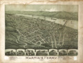
An aerial view of Martins Ferry in 1899.
See also
 In Spanish: Martins Ferry (Ohio) para niños
