Martlesham facts for kids
Quick facts for kids Martlesham |
|
|---|---|
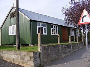
 Martlesham Village Hall |
|
| Population | 5,478 (2011) |
| OS grid reference | TM250467 |
| District |
|
| Shire county | |
| Region | |
| Country | England |
| Sovereign state | United Kingdom |
| Post town | Woodbridge |
| Postcode district | IP12 |
| Dialling code | 01394 |
| Police | Suffolk |
| Fire | Suffolk |
| Ambulance | East of England |
| EU Parliament | East of England |
| UK Parliament |
|
Martlesham is a village in Suffolk, England. It's about 3 kilometers (2 miles) southwest of Woodbridge. It's also about 10 kilometers (6 miles) east of Ipswich. Locals often call it "old Martlesham." This helps tell it apart from the newer Martlesham Heath area, which is about 1 kilometer (0.6 miles) south. Both places are part of the same local government area. At Martlesham Heath, you'll find BT's big research center, now known as Adastral Park.
Martlesham was first written down in the Domesday Book in 1086. Back then, it was called Merlesham. The name likely means 'settlement (hām) near the mooring-place (mǣrels)'. This suggests it was a place where boats could tie up.
Contents
Exploring Martlesham's Past
Ancient Roman Connections
People believe that Romans once lived in Martlesham. Over 26 Roman items have been found here. These include pottery, brooches, coins, and small tiles called tesserae. A special find was a small bronze statue of a horse. It had a Latin message saying it was a gift from a woman named Simplicia to the god Mars.
Martlesham in the Domesday Book
The Domesday Book is a famous record from 1086. It shows that Martlesham had about 120 hectares (300 acres) of good land. At that time, there were 10 villagers and 10 small farmers. The village also had meadows, a mill, and enough woodland for 16 pigs. They had many animals, including 5 horses, 20 cattle, 27 pigs, and 212 sheep. There were even 12 beehives! Martlesham also had a church with about 14.5 hectares (36 acres) of land.
Growth and Changes Over Time
Martlesham was mainly a farming area for a long time. The main part of the village slowly moved from the higher ground, where the church is, to where the main road from London to Great Yarmouth crosses the River Finn. The River Finn is a small river that flows into the Deben. By the mid-1400s, a bridge was built over the river at this spot.
In 1844, a guide to Suffolk described Martlesham as a "neat village." It noted that the village had 510 people and about 1,035 hectares (2,558 acres) of land. This land included rich marsh areas by the River Deben and a large, sandy, open heathland. This heathland stretched for about 3 kilometers (2 miles) and was used for grazing many sheep and cattle.
Martlesham Heath Airfield
In 1917, an important flying group moved to Martlesham. This group was called the Experimental Aircraft Flight. On January 16, 1917, Martlesham Heath Airfield officially opened. It was used to test new aircraft. It continued this role after World War I. The airfield became a very important RAF base during the Second World War. Famous pilot Douglas Bader was briefly stationed here in 1940. Today, a pub on Martlesham Heath is named "The Douglas Bader" after him.
After the airfield closed, its land was sold. A company then built the "New Village" of Martlesham Heath. This new area is southwest of "Old Martlesham."
Martlesham Today
Modern Martlesham Life
Today, Martlesham's main road goes northeast from the A12 roundabout. The village has a population of over 5,600 people. The main office for the Suffolk Constabulary, which is the police force for Suffolk, is located in Martlesham. It's on the south side of the A12/A1214 roundabout. The Martlesham site for the Ipswich park and ride service opened in December 2003. This service helps people park their cars and take a bus into Ipswich.
Local Landmarks and History
Martlesham has two pubs: Black Tiles and the Red Lion. The Red Lion was once a coaching inn on the old road from Norwich to London. It was a place where the Royal Mail would stop overnight. The mail was kept safe until morning. The pub's figurehead, a lion, was a well-known landmark. People used to say "Red as the Martlesham Lion" to describe something very red. The original lion figure is still outside the pub today. Parts of the building date back to the late 1500s. A brewery was also located here in Victorian times.
Martlesham Creek is a popular spot for sailing. It's where the River Fynn and the River Deben meet. School Lane is where the old schoolhouse used to be. This area still has open fields with views of the creek.
The Church of St Mary the Virgin
Church Lane and the area around it have been used for Christian worship since at least 1086. The Church of St Mary the Virgin was built in the 1400s. It's located down a single-track lane in the northeast of Martlesham. It has fields to the south and woods to the north. Many footpaths are in the area, and one path goes through the churchyard down to Martlesham Creek. Inside the church, you can see a pulpit from 1641 and a font from the 1400s near the entrance.
How Martlesham is Governed
Martlesham has its own electoral ward. This is a local area used for elections. In 2011, the population of this ward was 4,897 people. These people vote for local representatives who help make decisions for the area.
See also
 In Spanish: Martlesham para niños
 | Roy Wilkins |
 | John Lewis |
 | Linda Carol Brown |


