May Hill facts for kids
Quick facts for kids May Hill |
|
|---|---|

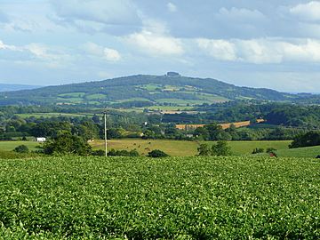
May Hill from Perrystone Hill
|
|
| Highest point | |
| Elevation | 296 m (971 ft) |
| Prominence | c. 217 m |
| Parent peak | Worcestershire Beacon |
| Listing | Marilyn |
| Geography | |
| Location | Gloucestershire, England |
| OS grid | SO695213 |
| Topo map | OS Landranger 162 |
May Hill is a famous hill in England. It sits between the towns of Gloucester and Ross-on-Wye. You can easily spot its top because of a group of trees. This area is special and protected. It is called a Site of Special Scientific Interest. You can reach the top of May Hill using three public walking paths. Two of these paths are part of the Gloucestershire Way and Wysis Way long-distance trails.
Contents
Why is it called May Hill?
There is a story that May Hill was named after a Captain May. He supposedly used the hill as a landmark when sailing on the River Severn. However, older documents show the hill was once called Yartleton Hill. It was renamed because of the fun May Day events held there.
May Day Celebrations
Every May Day, morris dancers perform at dawn on May Hill. Hundreds of people join them to celebrate. This special ceremony has been happening for centuries. Long ago, it even included a pretend battle between young people.
Exploring May Hill's Geography
May Hill is part of a group of low hills. These hills separate the River Severn from the River Wye. The very top of May Hill is 296 meters (971 feet) above sea level.
Views from the Summit
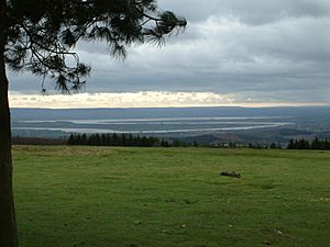
Among the trees at the top, you will find several benches. From these benches, you can see amazing views in all directions. You can look towards the Welsh borders. You can also see the lower parts of the River Severn. Large ships now use the Gloucester and Sharpness Canal to avoid this part of the river.
What is May Hill Made Of? (Geology)
May Hill is made of sandstone and siltstone rocks. These rocks are known as the May Hill sandstone. They include the Huntley Hill and Yartleton formations. These rocks are very old, from the Early Silurian period. They are shaped like a dome. Several cracks, called faults, cut through the dome. The most important one is the Blaisdon Fault. This fault separates May Hill from younger rocks in the Severn Vale.
Nature and Special Protection (Ecology and SSSI Status)
| Site of Special Scientific Interest | |

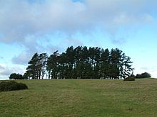
Trees on the summit of May Hill
|
|
| Area of Search | Gloucestershire |
|---|---|
| Coordinates | 51°53′27″N 2°26′38″W / 51.890765°N 2.443869°W |
| Interest | Biological/Geological |
| Area | 32.6 hectare |
| Notification | 1954 |
The top of May Hill is a special protected area. It covers 32.6 hectares (about 80 acres). It was officially named a Site of Special Scientific Interest (SSSI) in 1954. This means it is important for both its plants and animals, and its geology.
Trees and Plants
Most of May Hill is covered in trees. There are both coniferous (like pine trees) and deciduous (trees that lose leaves) types. The very top of the hill has grassland and heath areas. You can find small amounts of heather and gorse there.
The immediate summit has tall, old Corsican pines. These were planted in 1887 to celebrate Queen Victoria's Golden Jubilee. There is also one very old Scots Pine tree. These trees make May Hill easy to spot from far away. Younger trees around them were planted for Queen Elizabeth's Silver Jubilee.
Animals and Birds
Many birds live on May Hill. You might see meadow pipits, tree pipits, redstarts, and ravens. The woods below the summit are home to many woodcocks.
May Hill's Past (History)
The hill has an old circular trench, 100 meters wide. People believe it is an Iron Age earthwork. Inside this trench is a mound, likely a round barrow (an ancient burial site).
The Famous Trees
Records show that a group of trees has been on May Hill's summit since the late 1700s. In 1873, the hill's land was officially divided up. The trees were replanted in 1887 for Queen Victoria's Golden Jubilee. These are the trees that give the hill its unique look today.
Who Owns May Hill?
In 1935, 30 hectares (about 74 acres) of the hill became cared for by the National Trust. However, the very top of the hill is still owned by Longhope Parish Council. It is registered as a village green, meaning it's a common area for the community. More trees were planted in 1977 for the Silver Jubilee of Elizabeth II. A plaque at the top remembers this event.
May Hill in Art and Literature
May Hill has inspired many famous people. Poets like Edward Thomas and Robert Frost are linked to the hill. John Masefield wrote about May Hill in his poem "The Everlasting Mercy". The composer Gerald Finzi's ashes were scattered here in 1973. One of the benches on the summit is dedicated to writer Winifred Foley. She wrote about the Forest of Dean and lived nearby. An artist named Valerie McLean has even published a book of paintings and drawings of May Hill.


