
McDermitt, Nevada and Oregon facts for kids
Quick facts for kids
McDermitt
|
|
|---|---|

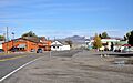
Central McDermitt
|
|

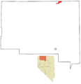
Location of McDermitt (Nevada side) in Humboldt County
|
|

McDermitt, Nevada and Oregon
Location in Nevada

McDermitt, Nevada and Oregon
Location in Oregon

McDermitt, Nevada and Oregon
Location in the United States
|
|
| Country | United States |
| State | Nevada and Oregon |
| County | Humboldt County, Nevada, and Malheur County, Oregon |
| Named for | Lt. Col. Charles McDermit, 2nd Cavalry, California Volunteers |
| Area | |
| • Total | 1.57 sq mi (4.06 km2) |
| • Land | 1.57 sq mi (4.06 km2) |
| • Water | 0.00 sq mi (0.00 km2) |
| Elevation | 4,432 ft (1,351 m) |
| Population
(2020)
|
|
| • Total | 124 |
| • Density | 79.13/sq mi (30.56/km2) |
| Time zone | UTC-8 (PST) |
| • Summer (DST) | UTC-7 (PDT) |
| ZIP codes |
89421 (NV) and 89425 (OR)
|
| Area code(s) | Area code 775 (NV), 458 and 541 (OR) |
| FIPS code | 32-44000 |
| GNIS feature ID | 0845557 |
McDermitt is a small community that sits right on the border between the states of Nevada and Oregon in the United States. It's not a city or town with its own government, but an "unincorporated community." This means it's part of a larger county.
McDermitt is located in both Humboldt County, Nevada, and Malheur County, Oregon. For a long time, its main ways of making money were through mining, ranching, and farming. However, the last big mine closed in 1990. This led to fewer people living there over time.
In 2010, about 513 people lived in McDermitt. A large number of these residents, about 75%, were American Indian. Most of them are from the Northern Paiute tribe, living on the Fort McDermitt Indian Reservation.
Contents
History of McDermitt
The community of McDermitt was first called Dugout. It got its name from Fort McDermit, a military fort nearby. The fort was named after Lieutenant Colonel Charles McDermit. He was a military commander who died in the area in 1865 during a fight with Native Americans. It's interesting that the spelling of the community's name is a little different from the fort's name.
Fort McDermit was built about 5 miles (8 km) away from where McDermitt is today. Its main purpose was to protect the important stagecoach route. This route went from Virginia City through Winnemucca to Silver City, which was then in Idaho Territory. This stage road was very important for the military to move supplies and people in southeast Oregon. The community of Dugout grew up to support the fort and its activities.
Geography and Climate
McDermitt is located right on U.S. Highway 95. It's about 73 miles (117 km) north of Winnemucca. The community sits at an elevation of about 4,432 feet (1,351 meters) above sea level.
The area around McDermitt is part of the Oregon High Desert. It has a desert climate, which means it's generally dry. On average, McDermitt gets about 9.2 inches (234 mm) of rain each year. Summers are hot and dry, while winters are cold. Most of the rain falls from March to June. Some rain and snow also occur from September to February.
| Climate data for McDermitt, Nevada and Oregon, 1991–2020 normals, extremes 1892–present | |||||||||||||
|---|---|---|---|---|---|---|---|---|---|---|---|---|---|
| Month | Jan | Feb | Mar | Apr | May | Jun | Jul | Aug | Sep | Oct | Nov | Dec | Year |
| Record high °F (°C) | 64 (18) |
68 (20) |
79 (26) |
89 (32) |
95 (35) |
105 (41) |
107 (42) |
107 (42) |
106 (41) |
94 (34) |
74 (23) |
65 (18) |
107 (42) |
| Mean maximum °F (°C) | 51.8 (11.0) |
58.5 (14.7) |
69.0 (20.6) |
77.1 (25.1) |
86.7 (30.4) |
94.1 (34.5) |
100.5 (38.1) |
98.3 (36.8) |
92.5 (33.6) |
81.5 (27.5) |
65.9 (18.8) |
53.3 (11.8) |
101.0 (38.3) |
| Mean daily maximum °F (°C) | 40.7 (4.8) |
46.1 (7.8) |
54.8 (12.7) |
61.0 (16.1) |
70.9 (21.6) |
80.6 (27.0) |
91.8 (33.2) |
90.1 (32.3) |
80.8 (27.1) |
66.2 (19.0) |
50.8 (10.4) |
39.6 (4.2) |
64.5 (18.0) |
| Daily mean °F (°C) | 29.0 (−1.7) |
33.5 (0.8) |
40.1 (4.5) |
45.1 (7.3) |
53.9 (12.2) |
61.7 (16.5) |
70.6 (21.4) |
67.8 (19.9) |
58.9 (14.9) |
46.6 (8.1) |
36.2 (2.3) |
28.0 (−2.2) |
47.6 (8.7) |
| Mean daily minimum °F (°C) | 17.4 (−8.1) |
21.0 (−6.1) |
25.4 (−3.7) |
29.3 (−1.5) |
36.9 (2.7) |
42.7 (5.9) |
49.4 (9.7) |
45.6 (7.6) |
37.0 (2.8) |
27.0 (−2.8) |
21.5 (−5.8) |
16.4 (−8.7) |
30.8 (−0.7) |
| Mean minimum °F (°C) | −3.8 (−19.9) |
2.7 (−16.3) |
10.4 (−12.0) |
15.1 (−9.4) |
20.9 (−6.2) |
28.9 (−1.7) |
37.8 (3.2) |
33.0 (0.6) |
23.3 (−4.8) |
10.7 (−11.8) |
1.3 (−17.1) |
−4.6 (−20.3) |
−11.1 (−23.9) |
| Record low °F (°C) | −32 (−36) |
−28 (−33) |
−1 (−18) |
6 (−14) |
10 (−12) |
20 (−7) |
27 (−3) |
20 (−7) |
8 (−13) |
−10 (−23) |
−18 (−28) |
−37 (−38) |
−37 (−38) |
| Average precipitation inches (mm) | 0.73 (19) |
0.50 (13) |
0.61 (15) |
1.01 (26) |
1.21 (31) |
0.86 (22) |
0.30 (7.6) |
0.17 (4.3) |
0.42 (11) |
0.67 (17) |
0.59 (15) |
0.78 (20) |
7.85 (200.9) |
| Average snowfall inches (cm) | 4.5 (11) |
3.8 (9.7) |
1.9 (4.8) |
1.7 (4.3) |
0.0 (0.0) |
0.0 (0.0) |
0.0 (0.0) |
0.0 (0.0) |
0.0 (0.0) |
0.4 (1.0) |
2.4 (6.1) |
6.1 (15) |
20.8 (51.9) |
| Average precipitation days (≥ 0.01 in) | 7.0 | 6.6 | 7.2 | 8.6 | 8.1 | 5.7 | 2.8 | 2.1 | 2.8 | 4.7 | 6.1 | 8.0 | 69.7 |
| Average snowy days (≥ 0.1 in) | 2.2 | 1.7 | 1.2 | 0.9 | 0.1 | 0.0 | 0.0 | 0.0 | 0.0 | 0.2 | 0.9 | 2.9 | 10.1 |
| Source 1: NOAA | |||||||||||||
| Source 2: XMACIS2 | |||||||||||||
McDermitt has the longest record of weather data in Nevada, going all the way back to 1866. The first weather stations in Nevada were set up at Army posts. The U.S. Army Signal Corps was in charge of weather observations in the late 1800s. They helped create the National Weather Service in 1870.
Population and People
| Historical population | |||
|---|---|---|---|
| Census | Pop. | %± | |
| 2020 | 124 | — | |
| U.S. Decennial Census | |||
For counting purposes, the census bureau divides McDermitt into two special areas. These are called census-designated places (CDPs). They are McDermitt, Nevada, and Fort McDermitt, Nevada. The part of McDermitt that is in Oregon is counted as part of the larger Ontario, OR–ID area.
Basically, the Fort McDermitt CDP includes the Fort McDermitt Indian Reservation. The McDermitt CDP includes the main community area next to it.
Fort McDermitt CDP

In 2010, 341 people lived in the Fort McDermitt CDP. About 30% of these residents were under 18 years old. About 11% were over 65 years old. Most of the people, 92%, were American Indian. A small number, 3.5%, were of two or more races, and 0.6% were White. There were 125 homes, and 86% of them were lived in.
McDermitt CDP
In 2010, 172 people lived in the McDermitt CDP. About 18% of these residents were under 18 years old. About 22% were over 65 years old. In this area, 24% of the people were American Indian. About 68% of the people were White. There were 101 homes, and 77% of them were lived in.
Economy and Jobs

McDermitt's economy has always been connected to mining, ranching, and farming. From 1917 to 1989, the area was home to four very important mercury mines. These mines were located in the McDermitt Caldera. They were called Bretz, Opalite, Cordero, and McDermitt. From 1933 to 1989, these mines were the biggest producers of mercury in North America. For example, in 1985, almost all the mercury produced in the U.S. came from the McDermitt Mine. When mercury mining stopped in 1990, the number of people living in McDermitt went down a lot.
There were also important gold mines nearby in the Santa Rosa Mountains. The National mine produced a lot of gold, and the Buckskin National mine produced gold and silver between 1906 and 1941.
Today, there are plans for new mining activities in the area. These include looking for gold and silver at Cordero and Buckskin-National, gallium at Cordero, and uranium at Aurora. The biggest places to work in McDermitt now are the Say When Bar, Restaurant & Casino, and the McDermitt Combined School.
Things to See and Do
A fun fact about McDermitt is that the state border actually runs right through the White Horse Inn. This building is a historical landmark that used to be a saloon and hotel. When it was open, people could order and pay for their food in the Oregon part of the building. This allowed them to avoid paying Nevada's state sales tax. The White Horse Inn is currently being restored.
Education in McDermitt
The Humboldt County School District runs the McDermitt Combined School. This school teaches students from kindergarten all the way through twelfth grade (K–12). It is located on the Nevada side of McDermitt.
The Oregon side of McDermitt has its own school district, McDermitt School District 51. This district doesn't have its own school building or employees anymore. Instead, all its students attend the McDermitt Combined School in Nevada. In 2006, about 16 students from the Oregon district went to school there.
For college, Humboldt County is served by Great Basin College. This college has a center in Winnemucca. The part of Malheur County where McDermitt, Oregon, is located is not part of any community college district.
McDermitt also has a public library. It is a branch of the Humboldt County Library.
Transportation
- McDermitt State Airport
Images for kids
-
Central McDermitt
-
Location of McDermitt (Nevada side) in Humboldt County
-

Kleinite (a rare mercury mineral) on calcite, from the Cordero Mine, McDermitt. Size: 4.9 x 3.1 x 2.6 cm.
-
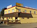
Desert Inn Casino
See also
 In Spanish: McDermitt (Nevada) para niños
